New blog post “Hurricane Irma Storm Surge in Tampa Bay“
Thankfully Hurricane Irma is now gone. Clean up efforts are underway in Florida and Georgia and surveys to SECOORA assets are beginning. In the meantime, take a look at Mark Luther’s Blog post “Hurricane Irma Storm Surge in Tampa Bay” to learn more about Irma’s impacts.
Taking the Pulse of the Storm
SECOORA assets are providing real-time information on Hurricane Irma.
|
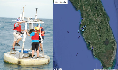
Buoys 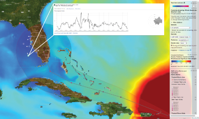 Buoys provide real-time measurements of conditions in the water. As Hurricane Irma moves closer to Florida, use the SECOORA Data Portal to view assets over modeled predictions. Pictured is the C13 buoy real-time wind speeds coupled with the CNAPS modeled Wind Induced Significant Wave Height. |
High Frequency Radar 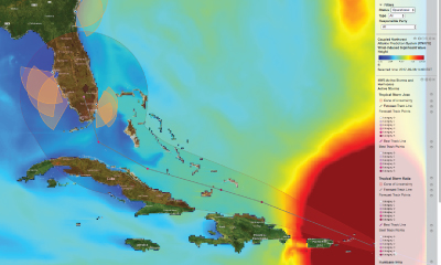 High Frequency (HFR) use radar technology to map surface currents in real-time. SECOORA and U.S. IOOS help support many HFR systems along the South Atlantic Bight. Pictured is Hurricane Irma’s predicted track over the HFR data coverage coupled with the CNAPS modeled Wind Induced Significant Wave Height |
Hurricane Tracking Resources
 |
|
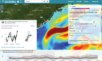
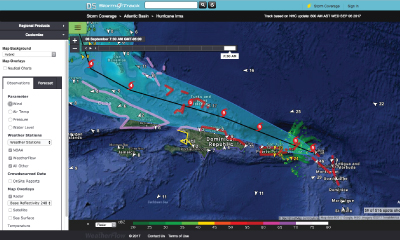
The SECOORA Data portal allows users to explore, download and visualize ocean and coastal data in the SECOORA domain. When a storm is approaching, check out the sensors map to see the storm data in real time. |
 |
|
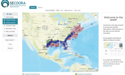
Visit the SECOORA Marine Weather Portal (MWP) for up-to-date weather hazards, tropical cyclone forecasts, and observations as hurricanes and tropical storms approach the southeast. The new National Weather Service Hurricane Threats and Impacts map has been added to the MWP which indicates worse case scenarios for planning purposes. |
 |
|
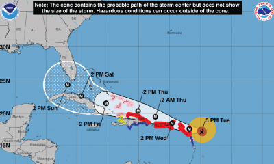
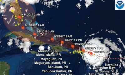
The National Hurricane Center (NHC) is the trusted source for hurricane information. Resources include predicted storm tracks and wind speed probabilities. |
 |
|
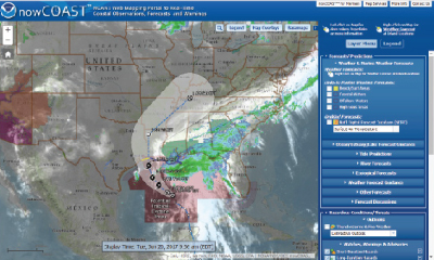
NOAA’s nowCOAST is a GIS-based online web mapping service which provides frequently updated weather and ocean observations, coastal and marine weather warnings and forecasts, and National Hurricane Center potential storm surge flooding maps. |
 |
|
StormTrack allows you to see the latest predicted track of an identified storm. By using their wealth of real time observations, meteorological tools, and precision models, you can see exactly how each storm is progressing. Each storm page grants access to premium level data for the duration of the storm. |
|
|
 |
|
Real time coastal wind, wave, and water level guidance is presented for the east central Florida coast, focusing on the Indian River Lagoon and Brevard County. Model products available on the site include: ADCIRC+SWAN numerical model using NOAA’s North American Mesoscale (NAM) model and the latest forecast/advisory from the National Hurricane Center (NHC). |
Storm Surge and Flooding Resources
 |
|
When NOAA issues a tropical storm warning for the U.S. or its territories, the Storm QuickLook is activated. This online tool is a snapshot of near real-time coastal and weather observations, the latest National Weather Service advisories, and time-series plots of water level and meteorological data at selected locations. |
 |
|
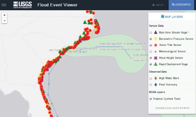
The USGS Flood Event Viewer (FEV) is the public data discovery component of the Short-Term Network (STN) database. It features 200+ USGS storm surge sensors and rapid deployment real-time gauges. |
 |
|
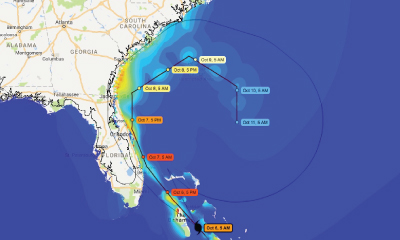
CERA is a component of the Advanced Surge Guidance System (ASGS). Based on the Advanced Circulation and Storm Surge model (ADCIRC), coupled with the SWAN Wave model, the ASGS generates real-time storm surge guidance for updating emergency response groups during a tropical or hurricane event. |
Data and Other Modeling Resources
 |
|
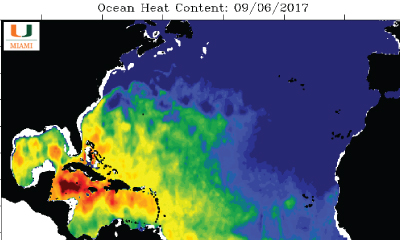
Ocean heat help fuel storms. The satellite derived sea surface temperature maps represents the integrated heat from the surface to the seafloor. Operated by Nick Shay, University of Miami Rosenstiel School of Marine and Atmospheric Science. |
 |
|
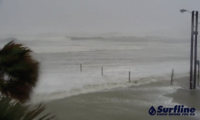
Surfline has cameras located all across the US. With many cameras in the SECOORA domain, users can choose a location and view live feeds of an approaching storm. They also have detailed surf zone forecasts provided by their LOLA wave model. In addition, explore their “Regional Forecast” and “Premium Analysis” products where a team of meteorologists provide value added observations and forecasts (written, video and audio) 365 days a year, with enhanced coverage during tropical events. |
 |
|
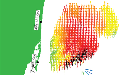
Track surface currents and waves related to Hurricane Irma. The University of Miami/Rosenstiel School of Marine and Atmospheric Sciences is currently operating three WERA High Frequency radars in Crandon Park on Key Biscayne, Virginia Key and John U Lloyd Park on Dania Beach. The radars at Crandon Park, Virginia Key, and Dania Beach provide measurement of ocean surface currents over a large area offshore of Miami, FL. The most recent hourly average surface current data is plotted on a 2.4 km grid. |
|
|
|
|
 |
|
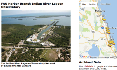
The Florida Atlantic University Harbor Branch operates Land/Ocean Biogeochemical Observatory (LOBO) units in the Indian River Lagoon and St. Lucie Estuary on the east coast of Florida. |
 |
|
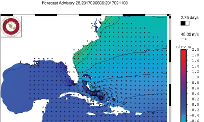
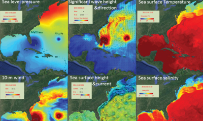
CNAPS is a three-dimensional marine environment nowcast and forecast model developed by the Ocean Observing and Modeling Group at North Carolina State University. This fully coupled ocean circulation, wave, and atmosphere model predicts ocean conditions based on data collected daily. |
Weather-Ready Nation Ambassador™
As a Weather-Ready Nation Ambassador™, SECOORA is committed to working with NOAA and other Ambassadors to strengthen national resilience against extreme weather. Click here to read more about WRN.
Email dmac@secooraorgpact.wpengine.com if you have any questions.
Related news

President Biden Proposes Significant Budget Cuts to IOOS for 2025
President Biden’s recent 2025 budget proposal slashed the funding allocated for the Integrated Ocean Observing System (IOOS) by 76%, which would effectively shut down coastal and ocean observing efforts.

Webinar: NOAA Resources to Help Coastal Communities Understand Flood Risk
Join us Wednesday, March 27th at 12 PM Eastern Time for SECOORA's Coastal Observing in Your Community Webinar Series to hear from Doug Marcy with the NOAA Office for Coastal Management.

Hiring: SCDRP Program Coordinator
The Southeast & Caribbean Disaster Resilience Partnership (SCDRP) is seeking a part-time Program Coordinator. Applications are due by April 1st, 2024.