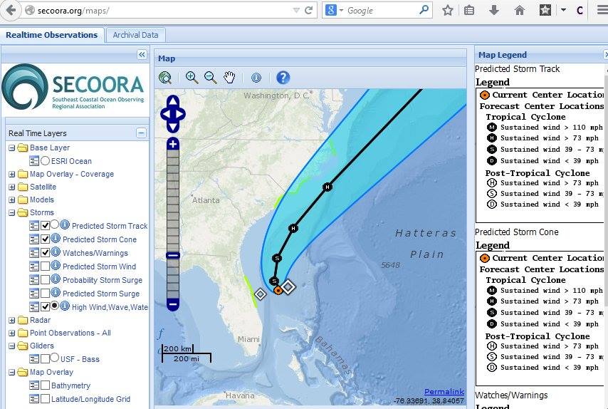
Tropical Storm Arthur
Follow Tropical Storm Arthur's path and more on our Interactive Regional Map or Marine Weather Portal. The diamonds represent an aggreagation of high wind, wave, water. The green highlighted areas along the coast of NC, SC, and FL represent watches/ warnings.
Follow our Facebook or Twitter for more frequent updates on Tropical Storm Arthur. |
|
Follow Tropical Storm Arthur's path and more on our Interactive Regional Map or Marine Weather Portal.
The diamonds represent an aggreagation of high wind, wave, water. The green highlighted areas along the coast of NC, SC, and FL represent watches/ warnings.
Follow our Facebook or Twitter for more frequent updates on Tropical Storm Arthur. |
Related news
GCOOS - SECOORA Joint Webinar Series: Building Synergy Across the US MBON & Ocean Acidification Networks
The GCOOS - SECOORA Webinar Series aims to strengthen collaborations across the Marine Biodiversity Observation Network (MBON) and regional Ocean Acidification Networks (GCAN and SOCAN).

New High Frequency Radar at the Dry Tortugas National Park Improves Ocean Surface Current Measurements Across the Straits of Florida
A new CODAR Low-Power SeaSonde HFR has been deployed by the University of South Florida at Fort Jefferson on Garden Key to measure surface currents to improve understanding and prediction of the Gulf of Mexico Loop Current.

President Biden Proposes Significant Budget Cuts to IOOS for 2025
President Biden’s recent 2025 budget proposal slashed the funding allocated for the Integrated Ocean Observing System (IOOS) by 76%, which would effectively shut down coastal and ocean observing efforts.