Thousands of U.S. citizens are still working to restore their homes and businesses after Hurricanes Harvey, Irma, and Maria wreaked havoc in the U.S. and Caribbean. We’ve all just experienced the most active hurricane season in recent memory.
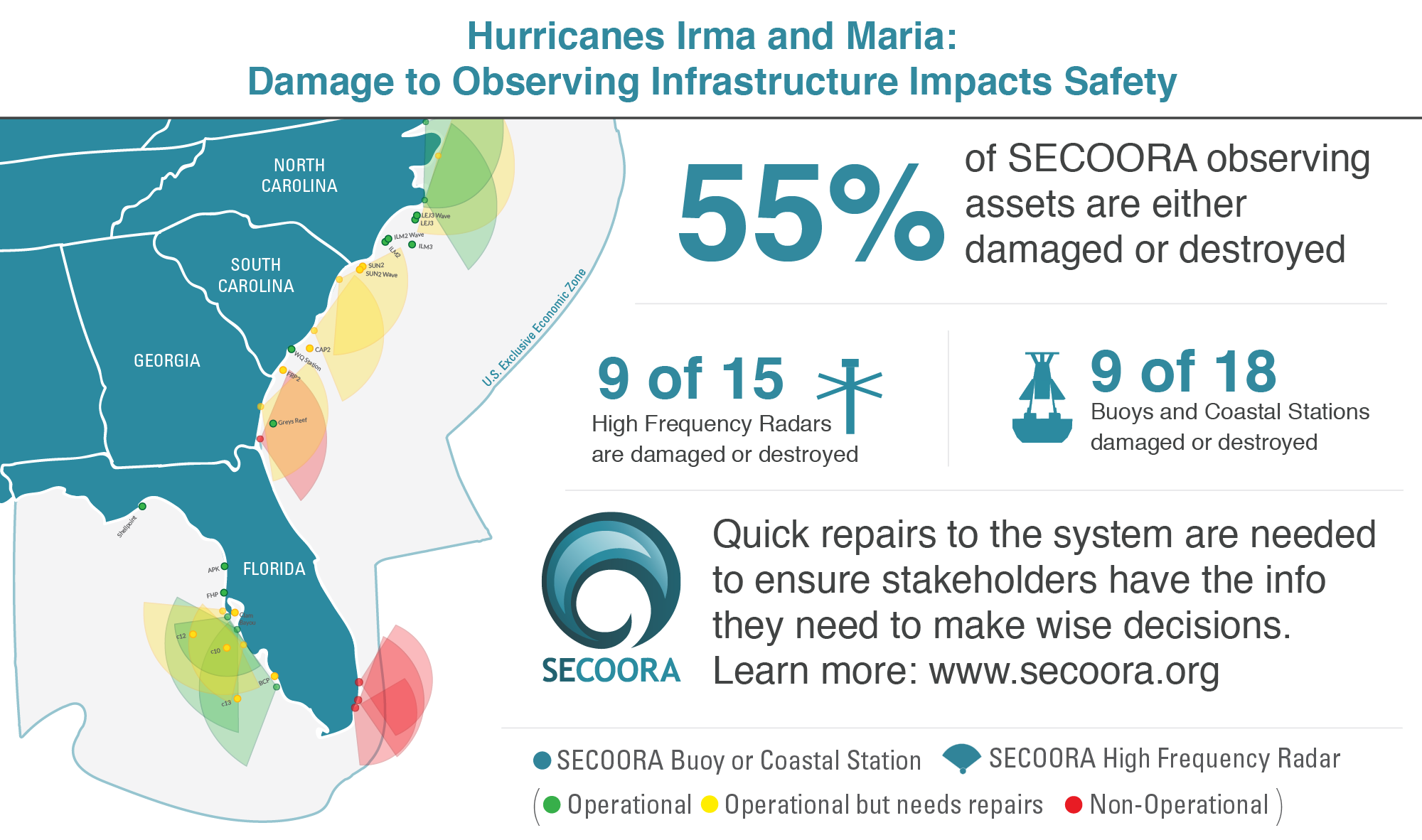
SECOORA’s observing infrastructure took a major hit – 55% of our observing assets are either damaged or destroyed. This critical infrastructure informs us as to whether our ocean ‘highways’ are safe for work and recreation. Without data, our ability to forecast and respond to future disasters in our region will be significantly impact. We need your help.
Damages to SECOORA Observing System
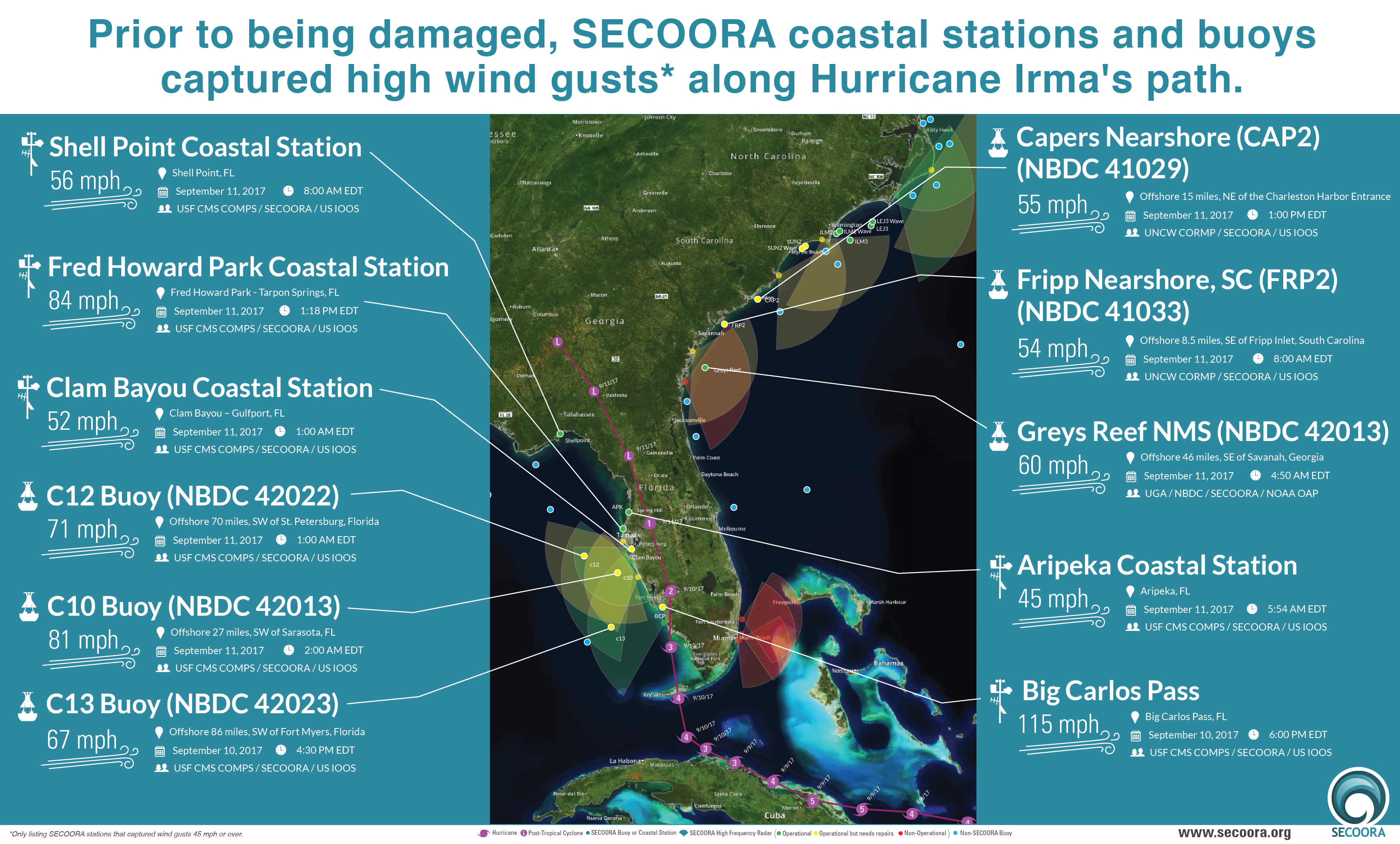 Prior to being damaged, SECOORA coastal stations and buoys captured high wind gust along Hurricane Irma’s path.
Damaged: 9 out of 15 High Frequency Radars
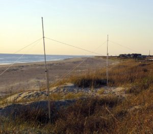 Land-based high frequency radar (HFR) provides real-time information on the speed and direction of surface currents over a large coverage area. This data can be used for US Coast Guard search and rescue operations and by emergency managers to track oil or other hazardous materials and harmful algal blooms.
The storm caused damage to 60% of the SECOORA HFR system. Nine out of 15 HFRs are non-operational or operational but in need of repairs. Electronics, antennae and wiring are needed to bring these radars back into online.
Damaged: 9 out of 18 Buoys and Coastal Stations
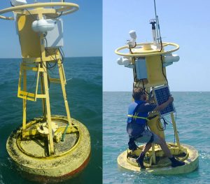
Moorings provide detailed time series data on sea state and meteorological conditions. Data from buoys and coastal stations is need for forecasts and to validate and improve model predictions, including storm surge models, wave height models, and storm tracks.
Only 50% SECOORA buoys and coastal stations are operating at full capacity, which increases the potential for loss of life during emergencies.
Jump to a detailed table outlining the damage to the SECOORA Observing System.
We need to repair equipment to forecast and respond to hurricanes.
Quick repairs to the system are needed to ensure NOAA National Weather Service, the U.S. Coast Guard, states, local emergency managers and the public have the information they need to make wise decisions.
What you can do:
1. Contact your senators and representatives and ask them to support supplemental funding for the IOOS. If you need help with contact information, please email abbey@secooraorgpact.wpengine.com.
2. Share both of the SECOORA and IOOS Association one-pagers. Page 2 of the SECOORA flyer shows which systems are damaged.
3. Remember that there were also very significant damages in the Caribbean (CariCOOS) and Texas (GCOOS).
Talking points:
1. Observations save lives and protect property by improving weather forecasts and warnings
2. We have detailed information on the damages in our region, if they need more information – click here
3. Without supplemental funding, the observing gaps in our region and the Caribbean, which are significant, will get even larger – increasing risks to people who live and work in our communities.
4. The supplemental funding request is for IOOS, which is a national program, and has three priorities. The first is to repair the damaged systems in SECOORA, CariCOOS and GCOOS regions. The second priority is to reduce the risk (harden) of future damage to the observing assets in these three hurricane prone regions. The third priority is to improve capacity across the national IOOS program to prepare and respond to extreme storms.
View the SECOORA Hurricane Damage One Pager
View the IOOS Association Hurricane Damage One Pager
Detailed information on SECOORA Damage
Prior to Hurricane Irma making landfall, SECOORA worked with each Principal Investigator to record the assets that were operational. Below is a table that reflects SECOORA’s damage estimates. SECOORA needs 1 million dollars to bring the system to 100% capacity.
SECOORA Damages: Irma and Maria |
|||||||
| Lead Org | Station Name | Location (State) | GPS Location | Station Type | Status Pre-Irma | Status Post-Irma & Maria | Total Cost to Repair/Replace |
| UNCW | LEJ3 | NC | 34.2073° N 76.9488° W |
Buoy | Operational | Fully Operational | $- |
| UNCW | LEJ3Wave | NC | 34.2073° N 76.9488° W |
Waverider Buoy | Buoy removed for service prior to storms | N/A | $- |
| UNCW | ILM3 | NC | 33.9877° N 77.3617° W |
Buoy | Operational | Fully Operational | $- |
| UNCW | ILM2 | NC | 34.1445° N 77.7183° W |
Buoy | Operational | Fully Operational | $- |
| UNCW | ILM2Wave | NC | 34.1445° N 77.7183° W |
Waverider Buoy | Operational | Fully Operational | $- |
| UNCW | SUN2 | NC | 33.8373° N 78.4768° W |
Buoy | Operational | Partially Operational | $2,825.37 |
| UNCW | SUN2 Wave | NC | 33.8373° N 78.4768° W |
Buoy | Operational | Partially Operational | $9,877.56 |
| UNCW | CAP2 | SC | 32.8033° N 79.6238° W |
Buoy | Operational | Partially Operational | $3,493.62 |
| UNCW | FRP2 | SC | 32.2745° N 80.4187° W |
Buoy | MET data reporting; CTD operational but internally logging | Partially Operational; cables and potentially solar panels damaged | $2,602.61 |
| UGA | OA sensors on mooring 41008 | GA | 31°24’0″ N 80°52’5″ W |
Buoy | Operational | Operational | $- |
| USF | C10 | FK | 27°10′ 22.80″ N 82°55′ 26.40″ W |
Buoy | Operational | Partially Operational | $41,449.96 |
| USF | C12 | FL | 27°30′ 18.00″ N 83°44′ 27.60″ W |
Buoy | Operational | Partially Operational | $44,937.60 |
| USF | C13 | FL | 26°0′ 36.00″ N 83°5′ 9.60″ W |
Buoy | Operational | Partially Operational | $51,449.97 |
| USF | Shell Point | FL | 30°3′ 28.80″ N 84°17′ 24.00″W |
Shorebased Tower | Operational, CTD removed from service | Operational | $- |
| USF | Aripeka | FL | 28°25′ 58.80″ N 82°40′ 1.20″ W |
Shorebased Tower | Operational | Operational | $- |
| USF | Fred Howard Park | FL | 28°9′ 10.80″ N 82°48′ 3.60″ W |
Shorebased Tower | Operational | Operational | $- |
| USF | Clam Bayou | FL | 27°44′ 9.60″ N 82°41′ 9.60″ W |
Shorebased Tower | Operational | Partially Operational | $9,514.86 |
| USF | Big Carlos Pass | FL | 26°24′ 14.40″ N 81°52′ 51.60″W |
Shorebased Tower | Operational | Partially Operational | $14,048.17 |
| UNC Chapel Hill | HATY | NC | Cape Hatteras, NC | HFR – CODAR | Operational | Partially operational | $18,887.92 |
| UNC Chapel Hill | DUCK | NC | Duck, NC | HFR – CODAR | Operational | Operational | $- |
| UNC Chapel Hill | CORE | NC | Core Banks, NC | – CODAR | Operational | Operational | $- |
| USC | CSW | NC | Caswell Beach, NC | HFR – WERA | Operational | Operational, needs repairs | $3,606.61 |
| USC | GTN | SC | Georgetown, SC | HFR – WERA | Operational | Operational, needs repairs | $18,522.17 |
| SkIO | CAT | GA | St. Catherine’s GA | HFR – WERA | Operational | Operational, needs repairs | $6,692.86 |
| SkIO | JEK | GA | Jekyll Island, GA | HFR – WERA | Operational | Non-operational | $48,885.92 |
| Univ. of Miami | STF | FL | Dania Beach, FL | HFR – WERA | Operational | Non-operational | $172,760.91 |
| Univ. of Miami | VIR | FL | Virginia Key, FL | HFR – WERA | Operational | Non-operational | $252,760.92 |
| Univ. of Miami | CDN | FL | Crandon, FL | HFR – WERA | Operational | Non-operational | $252,760.91 |
| USF | RDSR | FL | Reddington Shores, FL | HFR – CODAR | Operational | Operational, repairs needed | $29,581.22 |
| USF | FDS | FL | Ft. DeSoto, FL | HFR – WERA | Operational | Operational | $- |
| USF | VEN | FL | Venice, FL | HFR – WERA | Operational | Operational | $- |
| USF | VENI | FL | Venice, FL | HFR – CODAR | Operational | Operational, repairs needed | $25,597.04 |
| USF | NAPL | FL | Naples, FL | HFR – CODAR | Operational | Operational | $- |
| Total SECOORA Damage Estimate: $1,010,256.17 | |||||||
Related news

New High Frequency Radar at the Dry Tortugas National Park Improves Ocean Surface Current Measurements Across the Straits of Florida
A new CODAR Low-Power SeaSonde HFR has been deployed by the University of South Florida at Fort Jefferson on Garden Key to measure surface currents to improve understanding and prediction of the Gulf of Mexico Loop Current.

President Biden Proposes Significant Budget Cuts to IOOS for 2025
President Biden’s recent 2025 budget proposal slashed the funding allocated for the Integrated Ocean Observing System (IOOS) by 76%, which would effectively shut down coastal and ocean observing efforts.

Webinar: NOAA Resources to Help Coastal Communities Understand Flood Risk
Join us Wednesday, March 27th at 12 PM Eastern Time for SECOORA's Coastal Observing in Your Community Webinar Series to hear from Doug Marcy with the NOAA Office for Coastal Management.