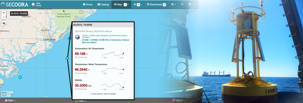
Two new buoys deployed near the entrance to the Port of Charleston are supporting ship operations and harbor pilots with much needed data. The buoys are maintained by UNCW Coastal Ocean Research and Monitoring Program and funded by IOOS and SECOORA.
Below is a list of data provided by the colocated buoys. Data is updated every hour.
- CHR60 (NDBC 41066): Wind speed, Wind gust, Wind from direction, Water temperature, Salinity, Air temperature, Air pressure, and Humidity
- GPS Location: 32°32.164’N, 079°39.355’W
- CHR60WAVE (NDBC 41076): Wave Height, Dominant Wave Period, Mean Wave Direction, and Water Temperature
- GPS location: 32°32.173’N, 079°39.531’W
Click here for CHR60 and CHR60WAVE data.
Partnerships to Fill Gaps
Ports, a major sector of the blue economy, rely on data provided by buoys. These new buoys are collecting valuable weather and sea state data for ships being moved into and out of the Charleston Harbor.
“The new buoys CHR60 and CHR60WAVE are already providing valuable weather and sea state data for ships transiting into and out of Charleston Harbor. This is important meteorological and oceanographic information to help aid in safe and efficient marine transportation.”
– Tom Boyle, Director, Vessel Operations, South Carolina Ports Authority
Utilizing Low Cost Technology
The team deployed a cost effective SOFAR Spotter buoy to collect the wave data needed by the Charleston Branch Pilots.
The ability to access user-friendly, low-cost technology remains a limiting factor in coastal ocean observing. Ocean observing equipment is difficult to deploy, costly to operate, and requires specific technical skills (doi10.12681/mms.25060).
Related news

New High Frequency Radar at the Dry Tortugas National Park Improves Ocean Surface Current Measurements Across the Straits of Florida
A new CODAR Low-Power SeaSonde HFR has been deployed by the University of South Florida at Fort Jefferson on Garden Key to measure surface currents to improve understanding and prediction of the Gulf of Mexico Loop Current.

President Biden Proposes Significant Budget Cuts to IOOS for 2025
President Biden’s recent 2025 budget proposal slashed the funding allocated for the Integrated Ocean Observing System (IOOS) by 76%, which would effectively shut down coastal and ocean observing efforts.

Webinar: NOAA Resources to Help Coastal Communities Understand Flood Risk
Join us Wednesday, March 27th at 12 PM Eastern Time for SECOORA's Coastal Observing in Your Community Webinar Series to hear from Doug Marcy with the NOAA Office for Coastal Management.