
After a slow start to the 2019 Atlantic hurricane season, the Southeast and Gulf of Mexico are starting to ramp up for Hurricane Dorian.
SECOORA is the coastal ocean observing system for the southeast U.S and eastern Gulf of Mexico. SECOORA invests in coastal and ocean observations that help with hurricane planning.
Explore our top four favorite hurricane resources and data products.
1) Eyes on the Storm
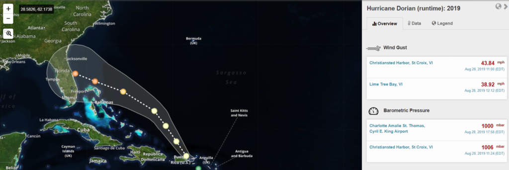
Eyes on the Storm is an interactive portal that connects you to hurricane and tropical storm data from past storms. Explore meteorological data as the storm progresses – see details on barometric pressure, wind gusts, temperature and wave heights.
Just launched in time for peak hurricane season- follow Hurricane Dorian live. Pull data from within 50 miles of the hurricane path and see highest wind speeds and wave heights and lowest barometric pressure. Click here to follow Hurricane Dorian.
2) Marine Weather Portal
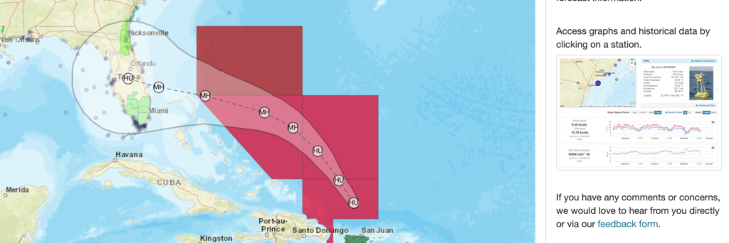
The SECOORA Marine Weather Portal (MWP) provides up-to-date weather hazards, tropical cyclone forecasts, and observations as hurricanes and tropical storms approach the Southeast and the Gulf of Mexico. The new National Weather Service Hurricane Threats and Impacts map overlays are available on the MWP, allowing you to identify worse case scenarios for planning purposes.
Access free coastal and offshore observations and forecasts in one convenient location by using the MWP.
3) SECOORA Data Portal and Data Views
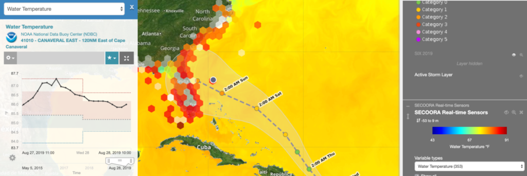
Having access to live storm data provides is essential for hurricane planning. The SECOORA Data Portal does its part by providing data to professionals, emergency planners, and scientists. Go to https://portal.secoora.org/ to explore the wide variety of information on weather, storms, climate and easy-to-browse data.
Create a Dorian Data View to stay up-to-date on the storm track and view environmental data near the storm. See the data view tutorial to learn how.
4) Hurricane Data Resource Page
A one-stop website for Hurricane Resources, SECOORA has compiled 23 useful links that go to regional data, live data, observation networks, and meteorological information. This reference is a great way to start exploring hurricane resources and regional ocean observing data.
—-
Data Disclaimer
Always adhere to your local to emergency management advisories during an extreme weather event.
There are no understandings, agreements, and representations, express or implied warranties (including any regarding merchantability or fitness for a particular purpose) respecting this data. Further, no employee of SECOORA, agent or other person is authorized to give any warranties on behalf of SECOORA, or to assume any liability in connection with the use of this data.
Related news

New High Frequency Radar at the Dry Tortugas National Park Improves Ocean Surface Current Measurements Across the Straits of Florida
A new CODAR Low-Power SeaSonde HFR has been deployed by the University of South Florida at Fort Jefferson on Garden Key to measure surface currents to improve understanding and prediction of the Gulf of Mexico Loop Current.

President Biden Proposes Significant Budget Cuts to IOOS for 2025
President Biden’s recent 2025 budget proposal slashed the funding allocated for the Integrated Ocean Observing System (IOOS) by 76%, which would effectively shut down coastal and ocean observing efforts.

Webinar: NOAA Resources to Help Coastal Communities Understand Flood Risk
Join us Wednesday, March 27th at 12 PM Eastern Time for SECOORA's Coastal Observing in Your Community Webinar Series to hear from Doug Marcy with the NOAA Office for Coastal Management.