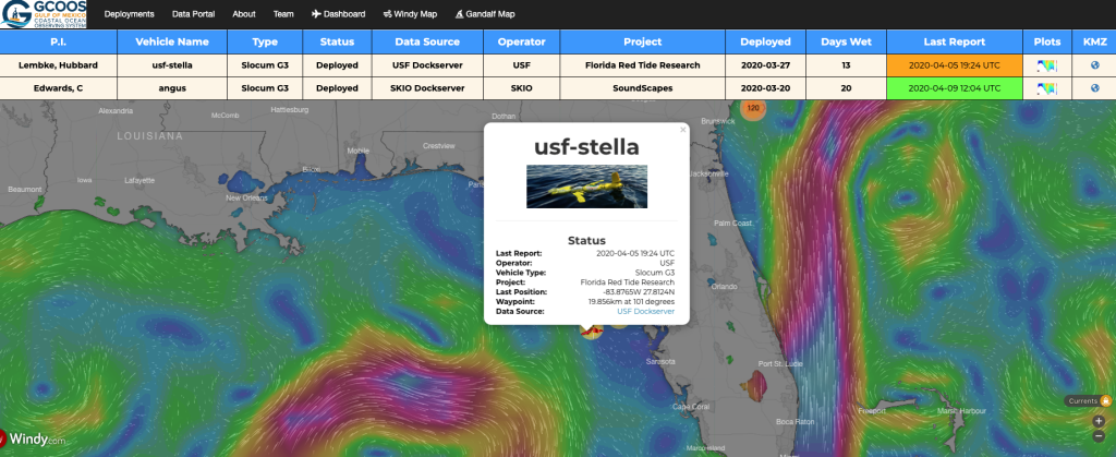
Figure 1. Data from the glider mission is available for anyone to view and download. Pictured above is Stella’s track on GANDALF—the Gulf AUV Network and Data Archiving Long-term Storage Facility. GANDALF was conceived as an aid to AUV pilots operating in the Gulf of Mexico and has since expanded to track glider missions outside the Gulf’s footprint.
An autonomous underwater glider named Stella has been diligently collecting water property data off the coast of Palm Harbor, FL, for 12 days. Data collected by Stella will be incorporated in model simulations to better understand red tide bloom occurrence. The glider mission was a joint effort between the University of South Florida College of Marine Science (USF CMS) and the Fish and Wildlife Conservation Commission- Florida Fish and Wildlife Research Institute (FWC-FWRI).
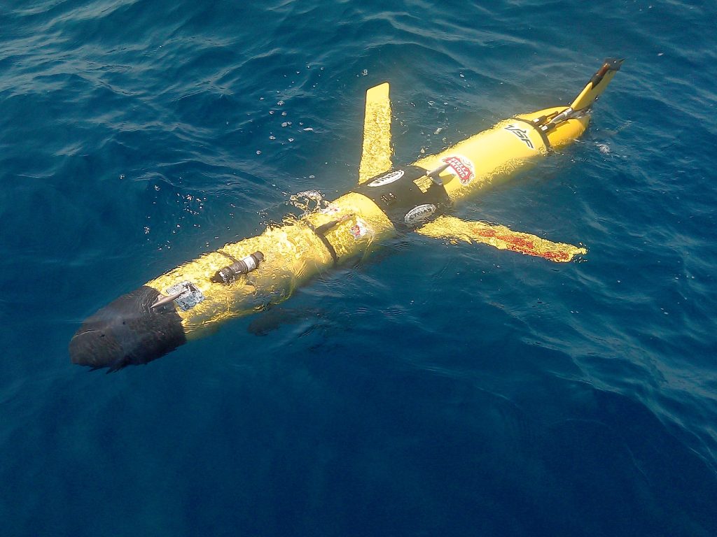
Figure 2. Pictured above is Stella in the water. Image is courtesy of Chad Lembke, USF CMS.
Stella (Fig. 2) is owned and operated by USF CMS and is equipped with sensors that measure water temperature, salinity, backscatter, color dissolved organic matter (CDOM), chlorophyll and dissolved oxygen. All of this information is used to shed light on how Florida red tide blooms are initiated offshore, transported to coastal waters, and eventually terminated.
Florida red tide occurs when high concentrations of the toxic dinoflagellate Karenia brevis are present in the water. K. brevis produces toxins called brevetoxins that can cause massive fish kills, weaken or kill marine mammals, and, when the toxin becomes aerosolized and inhaled, cause respiratory distress in humans and marine mammals.
Red tide bloom developments vary seasonally and inter-annually. The recent Stella mission is particularly timely because it occurred during the spring transition – when ocean surface temperatures shift from fall/winter cooling to spring/summer warming.
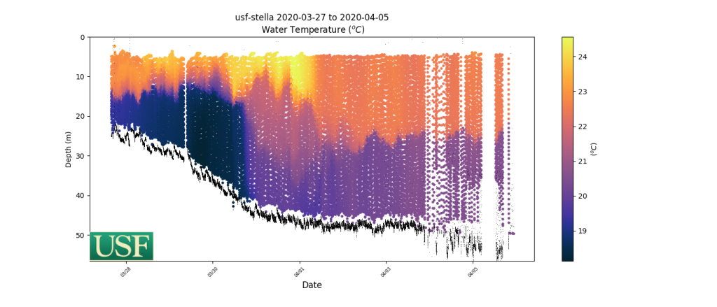
Figure 3. Pictured above is temperature data collected over the 12 day mission. Dr. Bob Weisberg, USF oceanographer, notes that the transect shows the development of the seasonal thermocline. It suggests that the West Florida Shelf is experiencing some upwelling.
Dr. Bob Weisberg, USF oceanographer, notes that the Stella transect in Fig. 3 shows the development of the seasonal thermocline. It suggests that the West Florida Shelf is experiencing some upwelling, a condition when near surface water moves away from the coast and is replaced by deeper water moving toward the coast. If such upwelling persists for a long enough interval, it is possible to change the nutrient state of the entire West Florida Shelf. Dr. Weisberg and other researchers are interested in learning if this change in nutrients is conducive to the formation of a major red tide bloom.
Anyone can access glider data for free on GANDALF—the Gulf AUV Network and Data Archiving Long-term Storage Facility – developed by GCOOS (Gulf of Mexico Ocean Observing System). While a glider is in-water, GANDALF provides real-time glider positioning information via a map-based interface with a dashboard display, plots of science sensors, Google Earth KMZ file generation, and access to processed data files. Once the glider is retrieved, post-processing of mission data is provided.
It takes a collaborative network to search for cues that a red tide bloom might be forming or ending, predict when and where nearshore impacts might occur after a bloom starts, and better understand why bloom severity varies geographically and over time. Dr. Kate Hubbard leads FWC-FWRI’s Harmful Algal Bloom Monitoring and Research Program, and is partnering with SECOORA, GCOOS, Mote Marine Laboratory, USF, and others to build more routine glider missions into red tide monitoring on the West Florida Shelf.

Bill Lingsch, new U.S. Underwater Glider User Group Coordinator, noted, “this glider operation is a true testament of a research institute and state agency collaborating in collecting in-situ data necessary to understand the dynamics causing and maintaining harmful algae blooms. This leads to forecasts and applications so public awareness (stakeholders/users) can be made possible to mitigate health impacts and/or prepare communities (recreation and commercial) for the potential biological impacts. ”
Gliders propel themselves by changing buoyancy to produce forward motion with wings that provide stability as the glider moves through the water column (Rudnick, 2004). Chad Lembke, USF CMS Project Engineer, further explains “gliders provide a robust method for obtaining water column variables over modest spatial and temporal scales for numerous scientific purposes such as hurricane strength forecasting, fisheries, and red tide.” Because gliders are less expensive to operate than ship-based research missions, they are a cost effective way to fill data gaps.
Data Made Possible By
Thank you to the following partners for helping assist in the mission!
Related news
GCOOS - SECOORA Joint Webinar Series: Building Synergy Across the US MBON & Ocean Acidification Networks
The GCOOS - SECOORA Webinar Series aims to strengthen collaborations across the Marine Biodiversity Observation Network (MBON) and regional Ocean Acidification Networks (GCAN and SOCAN).

New High Frequency Radar at the Dry Tortugas National Park Improves Ocean Surface Current Measurements Across the Straits of Florida
A new CODAR Low-Power SeaSonde HFR has been deployed by the University of South Florida at Fort Jefferson on Garden Key to measure surface currents to improve understanding and prediction of the Gulf of Mexico Loop Current.

President Biden Proposes Significant Budget Cuts to IOOS for 2025
President Biden’s recent 2025 budget proposal slashed the funding allocated for the Integrated Ocean Observing System (IOOS) by 76%, which would effectively shut down coastal and ocean observing efforts.