SECOORA Responds to Cape Canaveral Buoy Removal
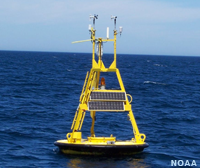
These two buoys located in the SECOORA footprint have provided valuable data to the maritime community and private and government weather forecasters. Many users need the near-shore and offshore wind, wave and temperature conditions provided by the buoys.
Examples of data 41009 and 41010 provide are: Air Temperature, Significant Wave Height, Wind Direction, Water Temperature, Swell Wave Height, and more.
"There's a lot of us that use that to check on local sea conditions and things of that nature. It's a good indicator to see what the offshore forecast is and the seas and so forth and to lose that, it would be the loss of another tool to keep tabs on the marine forecast here. People have relied on that for many, many years. We've all become accustomed to it here. It's a shame to lose it." - Mike Rigby, who fishes for red snapper and grouper and is also a boat driver with the Canaveral Pilots Association Quoted in The Florida Today article. |
In August, Conrad Lautenbacher, Jr., SECOORA Board Chairman, sent a formal letter to Kathy Sullivan, the NOAA Administrator, on behalf of the SECOORA Board regarding the removal of the two buoys. This is the first step in raising awareness of the degrading coastal ocean observing system. In September 2015, NOAA Administrator Kathy Sullivan sent a response back to Conrad Lautenbacher.
More and more frequently we are seeing buoys being pulled from the water due to limited funds. In February, University of North Carolina Wilmington Coastal Ocean Research and Monitoring Program and SECOORA started the Buoy for a Cause campaign to raise the additional $16,000 needed to replace the decommissioned NDBC buoy, 41036 (Onslow Bay Outer, NC). In less than three months, Buoy for a Cause successfully crowdsourced the money.This campaign demonstrated crowdsourcing, combined with other resources, can be used to keep buoys that collect and deliver valuable data in the water.
SECOORA (and its predecessors) have been engaged in coastal ocean observing activities in the SE for over fifteen years in collaboration with U.S. IOOS, NOAA and others. SECOORA will continue to work with the maritime community, the private sector, the public and government interests to address coastal ocean observing gaps in the Southeast US.. If you are interested in working on a collaborative initiative, please contact Debra Hernandez, SECOORA Executive Director, at debra@secooraorgpact.wpengine.com.
These two buoys located in the SECOORA footprint have provided valuable data to the maritime community and private and government weather forecasters. Many users need the near-shore and offshore wind, wave and temperature conditions provided by the buoys.
Examples of data 41009 and 41010 provide are: Air Temperature, Significant Wave Height, Wind Direction, Water Temperature, Swell Wave Height, and more.
 |
"There's a lot of us that use that to check on local sea conditions and things of that nature. It's a good indicator to see what the offshore forecast is and the seas and so forth and to lose that, it would be the loss of another tool to keep tabs on the marine forecast here. People have relied on that for many, many years. We've all become accustomed to it here. It's a shame to lose it." – Mike Rigby, who fishes for red snapper and grouper and is also a boat driver with the Canaveral Pilots Association Quoted in The Florida Today article. |
In August, Conrad Lautenbacher, Jr., SECOORA Board Chairman, sent a formal letter to Kathy Sullivan, the NOAA Administrator, on behalf of the SECOORA Board regarding the removal of the two buoys. This is the first step in raising awareness of the degrading coastal ocean observing system. In September 2015, NOAA Administrator Kathy Sullivan sent a response back to Conrad Lautenbacher.

More and more frequently we are seeing buoys being pulled from the water due to limited funds. In February, University of North Carolina Wilmington Coastal Ocean Research and Monitoring Program and SECOORA started the Buoy for a Cause campaign to raise the additional $16,000 needed to replace the decommissioned NDBC buoy, 41036 (Onslow Bay Outer, NC). In less than three months, Buoy for a Cause successfully crowdsourced the money.This campaign demonstrated crowdsourcing, combined with other resources, can be used to keep buoys that collect and deliver valuable data in the water.
SECOORA (and its predecessors) have been engaged in coastal ocean observing activities in the SE for over fifteen years in collaboration with U.S. IOOS, NOAA and others. SECOORA will continue to work with the maritime community, the private sector, the public and government interests to address coastal ocean observing gaps in the Southeast US.. If you are interested in working on a collaborative initiative, please contact Debra Hernandez, SECOORA Executive Director, at debra@secooraorgpact.wpengine.com.
Related news
SECOORA Request for Proposals for a Data System Development, Operations, and Maintenance Service Provider
SECOORA seeks a Data System Development, Operations, and Maintenance (DMAC) service provider to act as a strategic partner while maintaining the current SECOORA Data System. Proposals are due to SECOORA by 5:00 PM ET, March 31, 2026.

Plankton Perfect: Using Imagery to Document Microscopic Marine Life
Dr. Enrique Montes is working to understand how plankton respond to changes in the ocean by capturing high resolution imagery with advanced technology. This work is funded by the Marine Biodiversity Observation Network (MBON) to use novel techniques like the Continuous Particle Imaging and Classification System (CPICS).

SECOORA Community Spotlight: Craig Harris
When Craig Harris signed on as the Emergency Management and Resiliency Coordinator for the city of Wilmington, North Carolina, he brought with him knowledge of water level sensors. SECOORA worked with Craig to install a water level sensor at the Love Grove Bridge in Wilmington, a site prone to flooding.