Take your students by storm by using the SECOORA virtual hurricane classroom – featuring an “eye”-catching poster, hurricane information and activity websites, a hurricane glossary, and classroom activities. COSEE SouthEast, COSEE Gulf of Mexico, North Carolina SeaGrant, South Carolina SeaGrant, and UGA's Marine Extension Service are SECOORA education partners in developing these materials.
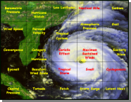
Forming Hurricanes Poster
This 36 by 32 inch poster, Forming Hurricanes, brings gusts of excitement to the classroom. Learn about concepts such as causes of hurricanes, hazards associated with hurricanes, and hurricane facts for the southeast Atlantic United States.
To get a full sized printed poster, contact your Sea Grant office:
North Carolina Sea Grant: Terri Hathaway
South Carolina Sea Grant Consortium: Carolyn Robinson
COSEE-SE Education Specialist for Georgia: Angela Bliss
Florida Sea Grant: Program Assistant
COSEE Gulf of Mexico and The Pier Aquarium. Contact the Pier Aquarium for shipping and handling charges.
For educators outside of FL, SC, GA and NC, contact the NOAA Outreach Unit: NOAA Outreach Distribution Unit 1305 East-West Hwy. Room 1W524 Silver Spring, MD 20910.
Atlantic Hurricane Tracking Chart
A chart to track hurricanes in the Atlantic Ocean.
Print out the chart. Monitor the National Hurricane Center for new Atlantic storm advisories. Read the latitude and longitude of the storms from the advisories. Mark the coordinates on the chart. Keep checking the advisories to see how the positions of the storms change with time. Perfect for following up the "Exploring Latitude and Longitude" classroom activity.
Hurricane Glossary: Learn the language of hurricanes
This handy online glossary helps students learn the most common scientific words heard in reference to hurricanes. Includes links to deeper explanations, tables explaining details about hurricane categories, and lists of example hurricanes.
Mind Blowing Hurricane Activities
|
||
|
||
|
||
|
||
|
