SECOORA Partners Monitor Red Tide Bloom in Gulf
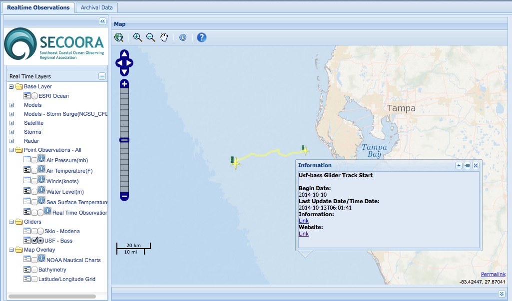
Karenia brevis, the Gulf of Mexico red tide organism, has been detected off the west coast of Florida. SECOORA partners Friday, August 1, released glider to monitor and map the bloom. University of South Florida’s (USF) glider, nicknamed Bass, is swimming along the West Florida Shelf, collecting and sending data back and was retrieved August 16, 2014. Bass was redeployed on September 8 and retrieved September 23. During the September mission, Bass traveled the western edge of the bloom on the surface and progressed WSW offshore out of the bloom area.
Red Tide Resources:
WFCOM Harmful Algal Bloom (HAB) 3.5 day trajectories forecast 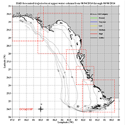 | FWC bulletin cell counts are inputted into the West Florida Coastal Ocean Model (WFCOM) Nowcast/Forecast model as available based on 5 detection levels (present, very low, low, medium, high) to trace physical transport of the observed biomass at the surface and bottom. |
USF Collaboration for Prediction of Red Tides Models 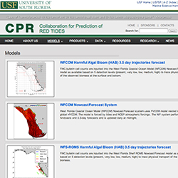 | |
USF Bass Glider 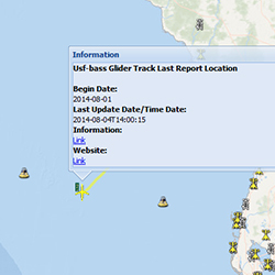 | Follow USF’s Bass Glider as it monitors and maps the red tide bloom. |
Ongoing Glider Mission on the West Florida Shelf  | As a joint effort of tracking and predicting the red tides in the eastern Gulf of Mexico and the U.S. southest coasts, a Slocum glider was deployed off the west Florida coast by the Ocean Technology Group at College of Marine Science, University of South Florida. The glider is collecting oceanographic data in the water clomun across the West Florida Continental Shelf. The near real-time data are shown in the following preliminary plots. |
FWC Red Tide Updates 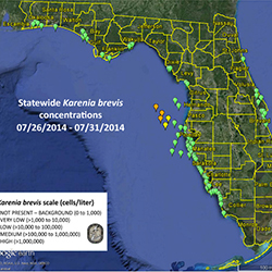 | Read summary reports of the current red tide conditions around Florida, including a map of sampling results and regional status reports. |
USF Bass Gilder's path tracked on SECOORA's Interactive Regional Map
USF Bass Gilder's path tracked on SECOORA's Interactive Regional Map
USF Bass Gilder's path tracked on SECOORA's Interactive Regional Map
August 5, 2014
Karenia brevis, the Gulf of Mexico red tide organism, has been detected off the west coast of Florida. SECOORA partners Friday, August 1, released glider to monitor and map the bloom. University of South Florida’s (USF) glider, nicknamed Bass, is swimming along the West Florida Shelf, collecting and sending data back and was retrieved August 16, 2014. Bass was redeployed on September 8 and retrieved September 23. During the September mission, Bass traveled the western edge of the bloom on the surface and progressed WSW offshore out of the bloom area.
Red Tide Resources:
|
WFCOM Harmful Algal Bloom (HAB) 3.5 day trajectories forecast
|
FWC bulletin cell counts are inputted into the West Florida Coastal Ocean Model (WFCOM) Nowcast/Forecast model as available based on 5 detection levels (present, very low, low, medium, high) to trace physical transport of the observed biomass at the surface and bottom.
|
|
USF Collaboration for Prediction of Red Tides Models
|
|
|
USF Bass Glider
|
Follow USF’s Bass Glider as it monitors and maps the red tide bloom.
|
|
Ongoing Glider Mission on the West Florida Shelf
|
As a joint effort of tracking and predicting the red tides in the eastern Gulf of Mexico and the U.S. southest coasts, a Slocum glider was deployed off the west Florida coast by the Ocean Technology Group at College of Marine Science, University of South Florida. The glider is collecting oceanographic data in the water clomun across the West Florida Continental Shelf. The near real-time data are shown in the following preliminary plots.
|
|
FWC Red Tide Updates
|
Read summary reports of the current red tide conditions around Florida, including a map of sampling results and regional status reports.
|
USF Bass Gilder's path tracked on SECOORA's Interactive Regional Map
USF Bass Gilder's path tracked on SECOORA's Interactive Regional Map
USF Bass Gilder's path tracked on SECOORA's Interactive Regional Map
Related news

News
July 23, 2026
Claire McGrath Joins SECOORA as Program and Development Manager
SECOORA welcomes Claire McGrath as Program and Development Manager, supporting the Southeast & Caribbean Coastal Disaster Resilience Partnership and membership growth.

Florida
July 14, 2026
Spotlight: Mobilizing to Save Florida’s Coral Reefs
Learn how scientists are racing to save Florida's Coral Reef through coral rescue, gene banking, reef restoration, and innovative conservation efforts after disease and marine heatwaves devastated one of America's most important marine ecosystems.

Florida
July 8, 2026
From a Whale’s Song to an Ocean’s Symphony: How AI Decodes Underwater Sound
Explore how SECOORA-funded research is using AI and machine learning to decode ocean soundscapes, detect boat noise, and support coral reef restoration efforts.