A NOAA Funded U.S. IOOS Coastal and Ocean Modeling Testbed (COMT) Project
Project Overview
As coastal ocean prediction science is pushed to the land-sea boundary, a critical need arises for implementation of a robust, efficient, multiscale, two-way model coupling methodology to accurately describe interactions between terrestrial hydrology (i.e. river input, precipitation, and run-off) and the coastal ocean. This project will address this need by developing a prototype prediction system that couples coastal ocean predictions with NOAA’s National Water Model (NWM) forecasts.
Why this Matters
This project, guided by user requirements, will provide an integrated coastal water predictive capability to deliver water intelligence products and information vital for decision making both during high-impact events, such as hurricanes, nor’easters, and storm surge, and for routine water management, including marine ecosystem health, transportation, and agriculture.
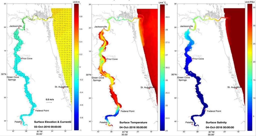
Sample model output for the St. John’s River showing surface elevation, temperature, and salinity during Hurricane Matthew, Oct. 2016
Project Locations
Two sites representing distinct river-ocean coupled systems will serve as study sites for this effort:
- Albemarle-Pamlico Sound, NC: a classic lagoonal system, where river-ocean exchange is through inlets on barrier islands. Complex river-ocean interactions happen especially during high-impact events when flooding, shoreline breaching, and/or formation of new inlets occur. Weather events such as hurricanes and nor’easters negatively impact landward communities and the agriculture industry
- St. John’s River, FL: a classic estuarine system, where continuous river-ocean interactions affect navigation, agriculture, and other important human activities on a daily basis.
Explore Draft Visualizations
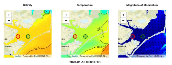
The team has pulled together animated maps of temperature, salinity, and surface currents (Magnitude of Momentum). The graphs show the changes over time in those parameters over two points on the map.
Click here to the explore the draft data products.
Project Partners
Fathom Science will lead the effort in developing the coupled river-ocean prediction system for both study sites.
SECOORA will work with stakeholders from NC and FL to determine the model outputs and products that will be beneficial to end users.
The project team will ultimately transition this modeling capability to NOAA’s National Ocean Service (NOS) and National Weather Service’s National Water Center (NWC), so these partners are integral in the scoping of the products and the transition planning.