Wave Heights And Currents in the Florida Straits (WHARF)
SECOORA HF Radar Waves Project Update |
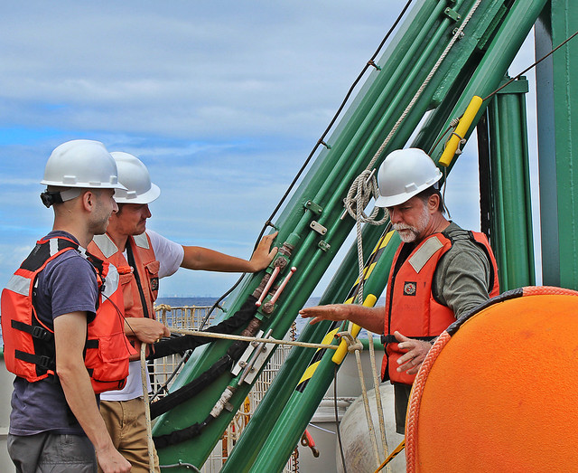 Image Credit: Jodi Brewster |
In April 2014, Dr. Nick Shay, SECOORA PI from the University of Miami (UM) Rosenstiel School of Marine & Atmospheric Science, his graduate student Matthew Archer and the crew onboard the R/V Walton Smith deployed a subsurface mooring in the Straits of Florida. |
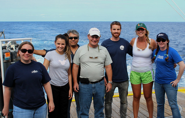 Image Credit: Jodi Brewster |
The mooring is equipped with a NortekUSA acoustic wave and current profiler (AWAC) instrument1. Matthew was a recipient of NortekUSA's Student Equipment Award and was awarded the AWAC to perform the experiment. The AWAC profiler is located at 25.93N and 79.88W in the UM maintained High Frequency (HF) radar footprint (between Dania Beach and Virginia Keys stations) in the Straits of Florida. 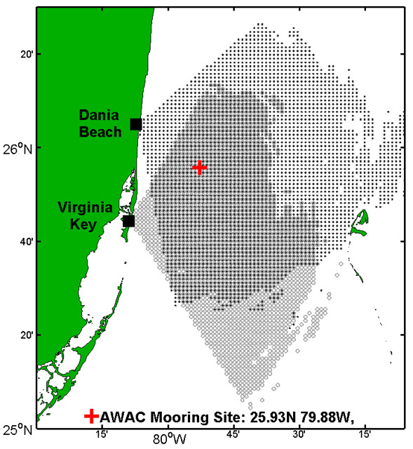 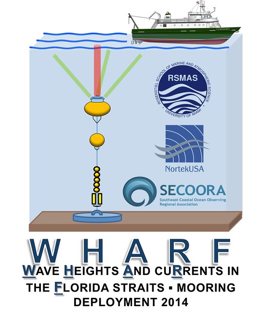 Images Credit: Lynn K. (Nick) Shay, UM |
It will obtain wave data in order to evaluate the WERA HFR derived significant wave height (SWH) measurements.2 The AWAC is expected to provide a three month time series. The measurements obtained during the spring and summer transition period will allow proper calibration of the HF Radar wave measurement algorithm. The data from AWAC, coupled with the HF radar, satellite sea surface temperature and local wind velocity observations will provide a comprehensive four-dimensional (x, y, z, t) dataset to resolve the flow-field evolution at the shelf-break.1The intent is to deliver a quality control index for the extraction of real-time SWH fields for use by the National Weather Service forecasters to evaluate the marine forecasts in the Florida Straits.2 For more information, please contact Nick Shay at lshay@rsmas.miami.edu. |
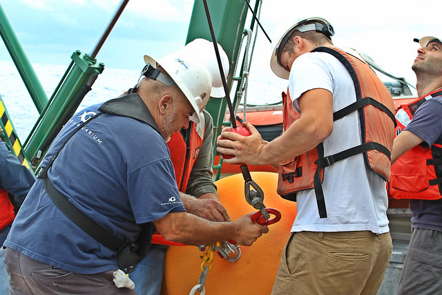 Image Credit: Jodi Brewster  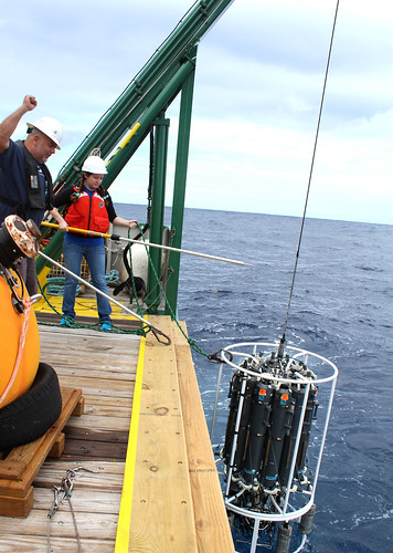 Image Credit: Jodi Brewster Image Credit: Jodi Brewster |
----- 1Archer, Matthew. "Upper Ocean Current Velocity and Directional Wave Field Observations in the Straits of Florida." NortekUSA Student Equipment Grant 2013 - Abstract (http://www.nortekusa.com/usa/support/student-equipment-grants/2013-grants/awards) 2Shay, Lynn K., Matthew R. Archer, Brian K. Hause, and Freda Zifteh. "Regional Coastal Ocean Observing System: Evaluating Significant Wave Heights from WERA High Frequency Radars." Southeast Coastal Ocean Observing Regional Association- SECOORA HF Radar Waves Project Proposal |
June 12, 2014
|
SECOORA HF Radar Waves Project Update
|
|
Image Credit: Jodi Brewster
|
|
In April 2014, Dr. Nick Shay, SECOORA PI from the University of Miami (UM) Rosenstiel School of Marine & Atmospheric Science, his graduate student Matthew Archer and the crew onboard the R/V Walton Smith deployed a subsurface mooring in the Straits of Florida.
|
|
Image Credit: Jodi Brewster
|
|
The mooring is equipped with a NortekUSA acoustic wave and current profiler (AWAC) instrument1. Matthew was a recipient of NortekUSA's Student Equipment Award and was awarded the AWAC to perform the experiment. The AWAC profiler is located at 25.93N and 79.88W in the UM maintained High Frequency (HF) radar footprint (between Dania Beach and Virginia Keys stations) in the Straits of Florida.
Images Credit: Lynn K. (Nick) Shay, UM
|
|
It will obtain wave data in order to evaluate the WERA HFR derived significant wave height (SWH) measurements.2 The AWAC is expected to provide a three month time series. The measurements obtained during the spring and summer transition period will allow proper calibration of the HF Radar wave measurement algorithm. The data from AWAC, coupled with the HF radar, satellite sea surface temperature and local wind velocity observations will provide a comprehensive four-dimensional (x, y, z, t) dataset to resolve the flow-field evolution at the shelf-break.1The intent is to deliver a quality control index for the extraction of real-time SWH fields for use by the National Weather Service forecasters to evaluate the marine forecasts in the Florida Straits.2 For more information, please contact Nick Shay at lshay@rsmas.miami.edu.
|
|
Image Credit: Jodi Brewster
Image Credit: Jodi Brewster Image Credit: Jodi Brewster
|
|
—–
1Archer, Matthew. "Upper Ocean Current Velocity and Directional Wave Field Observations in the Straits of Florida." NortekUSA Student Equipment Grant 2013 – Abstract (http://www.nortekusa.com/usa/support/student-equipment-grants/2013-grants/awards)
2Shay, Lynn K., Matthew R. Archer, Brian K. Hause, and Freda Zifteh. "Regional Coastal Ocean Observing System: Evaluating Significant Wave Heights from WERA High Frequency Radars." Southeast Coastal Ocean Observing Regional Association- SECOORA HF Radar Waves Project Proposal
|
Related news

News
July 23, 2026
Claire McGrath Joins SECOORA as Program and Development Manager
SECOORA welcomes Claire McGrath as Program and Development Manager, supporting the Southeast & Caribbean Coastal Disaster Resilience Partnership and membership growth.

Florida
July 14, 2026
Spotlight: Mobilizing to Save Florida’s Coral Reefs
Learn how scientists are racing to save Florida's Coral Reef through coral rescue, gene banking, reef restoration, and innovative conservation efforts after disease and marine heatwaves devastated one of America's most important marine ecosystems.

Florida
July 8, 2026
From a Whale’s Song to an Ocean’s Symphony: How AI Decodes Underwater Sound
Explore how SECOORA-funded research is using AI and machine learning to decode ocean soundscapes, detect boat noise, and support coral reef restoration efforts.