

Undergraduate Environmental Science Lab Tours Water Quality Monitoring Station
On October 29th, SECOORA joined USF COMPS Systems Engineer, Jeffrey Scudder, and YSI Senior Applications Specialist, Mike Lizotte, as they hosted a tour of the USF COMPS Clam Bayou water quality station. A University of South Florida St. Petersburg environmental science lab applied classroom knowledge about water quality systems to the field.
During the tour, the students learned about the new YSI Xylem EXO2 Multi-Parameter Water Quality Monitoring sonde. The sonde system measures salinity, dissolved oxygen, pH, water temperature, turbidity, chlorophyll, blue green algae, and fluorescent dissolved organic matter and depth. This water quality data augments the station’s wind, air temperature, relative humidity, precipitation, and barometric pressure measurements.
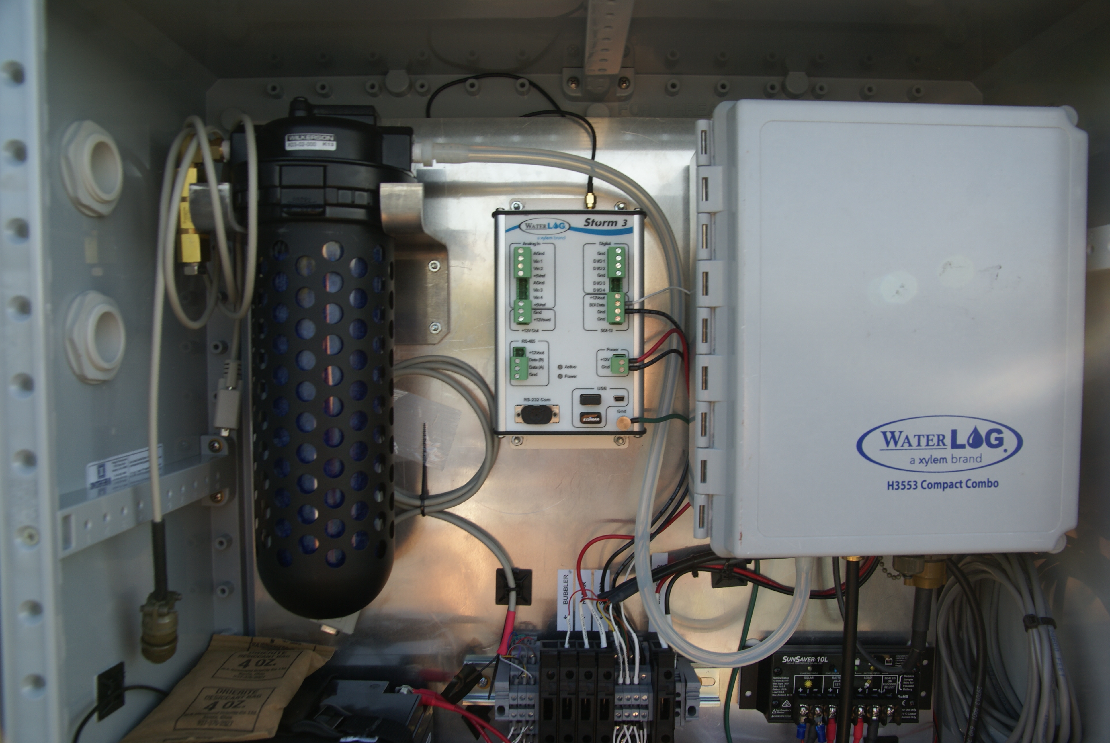
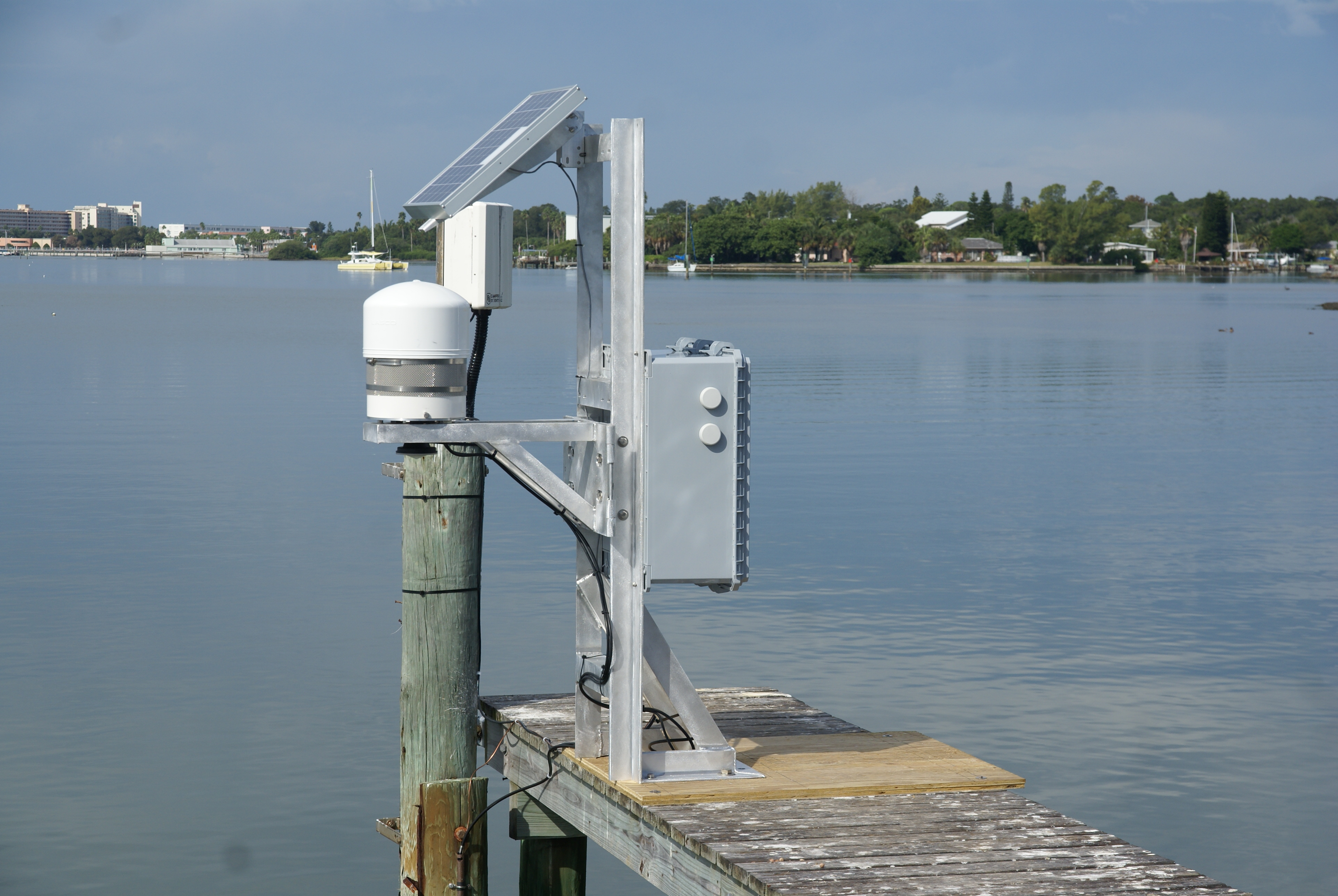
Mike and Jennifer Bishop, YSI Quality Engineer, showcased a new sensor array they were incorporating into the Clam Bayou station. They installed an YSI WaterLog bubbler and radar water level sensor. Both sensors measure water level using different technologies. Clam Bayou is serving as a developmental site to show how these sensors could be used in a coastal environment to measure sea level rise accurately. Data can also be used by the weather service for storm surge measurement. Bubblers and radars are mainly found in freshwater water quality and level monitoring systems. Pictured below is the system installed.
----
Images Credit: Jennifer Bishop, Xylem YSI
On October 29th, SECOORA joined USF COMPS Systems Engineer, Jeffrey Scudder, and YSI Senior Applications Specialist, Mike Lizotte, as they hosted a tour of the USF COMPS Clam Bayou water quality station. A University of South Florida St. Petersburg environmental science lab applied classroom knowledge about water quality systems to the field.
During the tour, the students learned about the new YSI Xylem EXO2 Multi-Parameter Water Quality Monitoring sonde. The sonde system measures salinity, dissolved oxygen, pH, water temperature, turbidity, chlorophyll, blue green algae, and fluorescent dissolved organic matter and depth. This water quality data augments the station’s wind, air temperature, relative humidity, precipitation, and barometric pressure measurements.
Mike and Jennifer Bishop, YSI Quality Engineer, showcased a new sensor array they were incorporating into the Clam Bayou station. They installed an YSI WaterLog bubbler and radar water level sensor. Both sensors measure water level using different technologies. Clam Bayou is serving as a developmental site to show how these sensors could be used in a coastal environment to measure sea level rise accurately. Data can also be used by the weather service for storm surge measurement. Bubblers and radars are mainly found in freshwater water quality and level monitoring systems. Pictured below is the system installed.
—-
Images Credit: Jennifer Bishop, Xylem YSI
Related news

Meet SECOORA’s 2026-2027 Executive Committee
Meet SECOORA’s 2026-2027 Executive Committee, five leaders in marine science, coastal engineering, and weather who guide ocean observing in the Southeast.

Investing in People and Communities Across the Southeast
SECOORA begins its 4th five-year award from U.S. IOOS to continue coastal and ocean monitoring across the Southeast.
Meet the Scientist Helping Answer: Are Our Marshes Gaining Elevation?
Meet Ches Vervaeke, the scientist bringing 20+ years of Surface Elevation Table expertise to SECOORA's marsh elevation monitoring work in the Southeast.