Hurricane Glossary
Hurricanes are large, swirling storms and are prominent in the Southeast United States. SECOORA created this handy online glossary helps students learn the most common scientific words heard in reference to hurricanes. Definitions were selected and adapted from weather.com.
Atmospheric Pressure: The pressure exerted by the atmosphere at a given point. Its measurement can be expressed in several ways, including millibars and inches of mercury (Hg). Average sea level pressure is 1013.25 millibars or 29.92 inches of mercury. A drop in atmospheric pressure usually indicates the approach of a storm, such as a hurricane.
Barometric Pressure: The pressure exerted by the atmosphere at a given point (as measured by a barometer). It can be measured in millibars or inches of mercury, among others. Watching a barometer for a drop in atmospheric pressure helps forecasters determine when a hurricane is approaching.
Beaufort Wind Scale: A system for estimating and reporting wind speeds. It is based on the visible effects of wind upon land objects (such as vegetation) and/or sea surface conditions such as white caps and foam. The scale was devised by Sir Francis Beaufort (1777-1857), hydrographer to the British Royal Navy.
Calm: Atmospheric conditions without significant wind or rain. In oceanic terms, it includes the apparent absence of motion of the water surface when there is no wind or swell.
Convection: Hurricanes develop over warm tropical oceans where the sea surface temperature is ~26.5 C (80 F) or warmer. In weather processes, there is circulation of fluid (air) that serves to equalize temperatures. An example is air flow between ocean and land during day and during night. Hurricanes use warm ocean waters for convection, often allowing for an increase in strength. Warmer water allows for an increase in storm strength.
Coriolis effect: A force per unit mass that arises solely from the earth’s rotation, acting to deflect fluid parcels that are in motion. The Coriolis Effect is dependent on the latitude and the speed of the moving object. The Coriolis effect is stronger at higher latitudes and is equal to zero at the equator. Hurricanes can’t cross the equator because a steadily decreasing Coriolis effect will stop the storm from spinning. In the Northern Hemisphere, Coriolis’ deflecting force causes air and water to deflect to the right of its path, while in the Southern Hemisphere they are deflected to the left of their path. This is the effect that causes a hurricane to rotate counter-clockwise (or have cyclonic motion.) Ocean currents in the Northern Hemisphere such as the Gulf Stream are deflected to the right as well.
Data Buoys: Instrumented buoys placed throughout United States coastal and ocean waters that collect and relay data or information on air and water temperature, wind speed, air pressure, and wave conditions through several media. For hurricanes, these buoys are used to gather information to help predict hurricane strengthening or weakening and direction of movement.
Disturbance: An area in the atmosphere exhibiting signs of potential cyclone development.
Dropsonde: A weather reconnaissance device designed to be dropped from an airplane. The dropsonde includes meteorological instruments attached to a parachute. A vertical profile of the atmosphere is returned to meteorologist’s computers as the dropsonde collects the data as it descends from the airplane to the ocean surface. Dropsondes are used by the Hurricane Hunter aircrafts to obtain the minimum central pressure in the eye of the hurricane, and conditions throughout the storm.
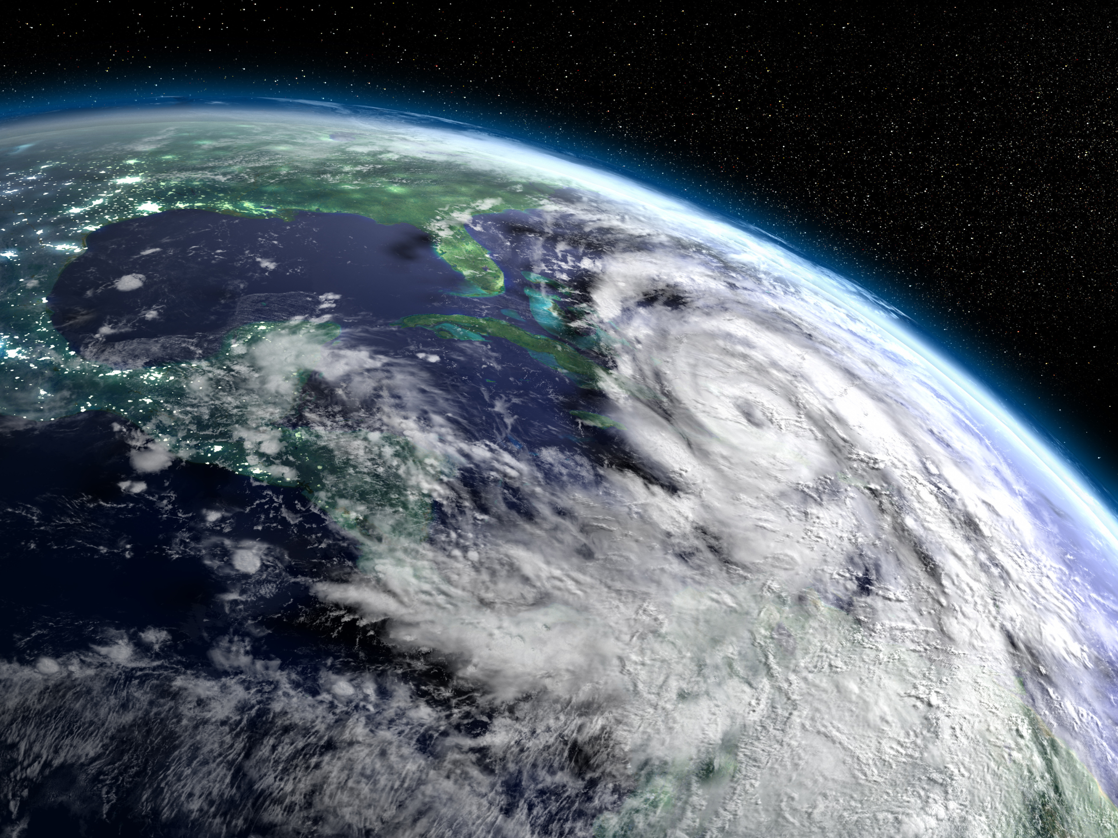
Eye: The center of a tropical storm or hurricane, with a roughly circular area of light winds and rain-free skies. An eye will usually develop when the maximum sustained wind speeds exceed 78 mph. It can range in size from 5 miles to 60 miles in diameter, but the average size is 20 miles. When the eye begins to shrink in size, the storm is usually intensifying. Highly organized storms have a smaller eye which indicates greater intensity. Inside the eye of a hurricane, there is no rain and winds are light.
Eyewall: An organized band of storms surrounding the eye, or center, of a tropical cyclone. An eyewall contains cumulonimbus clouds, intense rainfall and very strong winds. This is the most intense part of the hurricane, containing maximum wind speeds, heavy hail, and the heaviest rainfall.
Fetch: The area over which the wind blows steadily. The greater the fetch, the greater the wave height. In a hurricane, fetch, wind speed, and wind direction associated with the storm will determine the storm surge as the storm moves landward.
Forward velocity: The speed at which a hurricane moves along its path. Slow-moving hurricanes (those with a low forward velocity) provide more opportunity for people to prepare.
Gale: On the Beaufort Wind Scale, defined as winds with speeds from 28 to 55 knots (32 to 63 miles per hour). “Gale force winds” are often associated with the outer portion hurricanes.
Gulf Stream: The warm, swift, relatively narrow ocean current that flows from south to north off the southeast Atlantic coast of the United States. The warm waters of the Gulf Stream often feed hurricanes by providing warm water that might be patchy elsewhere.
Gust: A sudden significant increase in or rapid fluctuations of wind speed. Peak wind speed must reach at least 16 knots (18 miles per hour); the duration is usually less than twenty seconds. Hurricane gusts have speeds 10mph or greater faster than a hurricane’s sustained wind speed.
Hurricane: The name for a tropical cyclone with sustained winds of 74 miles per hour (65 knots) or greater in the North Atlantic Ocean, Caribbean Sea, Gulf of Mexico, and in the eastern North Pacific Ocean. Tropical cyclones are known as typhoons in the western Pacific and cyclones in the Indian Ocean.
Hurricane Warning : A formal advisory issued by forecasters at the National Hurricane Center when they have determined that hurricane conditions are expected in a coastal area or group of islands within a 24 hour period. A warning is used to inform the public and marine interests of the storm’s location, intensity, and movement.
Hurricane Watch: A formal advisory issued by forecasters at the National Hurricane Center when they have determined that hurricane conditions are a potential threat to a coastal area or group of islands within a 24 to 36 hour period. A watch is used to inform the public and marine interests of the storm’s location, intensity, and movement.
Isobars: A line drawn on a weather map connecting points of equal pressure. Isobars take the shape of concentric circles around a hurricane or any “closed” low pressure system.
Latent heat: The energy released or absorbed during a change of state, for example, in changing from a liquid to a gas. In a hurricane, latent heat comes from warm ocean water that is turned to steam providing energy to the storm. This is one ingredient needed to form & strengthen a hurricane.
Latitude: The location north or south in reference to the equator, which is designated at 0 degrees. Lines of latitude on a map or globe are parallel lines that circle the globe both north and south of the equator. The poles are at 90 degrees North and South latitude.
Low Latitudes: Latitudes between 30 and 0 degrees North and South of the equator. Also referred to as the tropical or torrid region. Most hurricanes develop at low latitudes (where waters are warmest).
Low Pressure System: An area of a relative pressure minimum that has converging winds and rotates in the same direction as the earth. This is counterclockwise in the Northern Hemisphere and clockwise in the Southern Hemisphere. Also known as a cyclone, it is the opposite of an area of high pressure (anticyclone).
Maximum sustained winds: This describes the hurricanes’ steady winds. Unlike hurricane gusts, maximum sustained winds must last over twenty seconds continuously. This determines the category of the hurricane on the Saffir-Simpson Scale.
Millibar (MB): The standard unit of measurement for atmospheric pressure used by the National Weather Service. One millibar is equivalent to 100 newtons per square meter or .029 inches of Mercury. Standard surface pressure is 1013.2 millibars.
Saffir-Simpson Scale: This scale classifies hurricanes based on their intensity, and is used to predict how damaging the hurricane will be to property. Saffir-Simpson classifies hurricanes from a scale of 1 (minimal) to 5 (catastrophic.)
This scale was developed in the early 1970s by Herbert Saffir, a consulting engineer in Coral Gables, Florida, and Dr. Robert Simpson, then Director of the National Hurricane Center. The scale is based primarily on wind speeds and includes estimates of barometric pressure and storm surge associated with each of the five categories.
| Category | Central Pressure | Winds | Surge |
| 1 — Minimal | Greater than 980 mb or 28.94 in | 74 to 95 mph or 64 to 83 kts | 4 to 5 feet |
| 2 — Moderate | 965 to 979 mb or 28.50 to 28.91 in | 96 to 110 mph or 65 to 96 kts | 6 to 8 feet |
| 3 — Extensive | 945 to 964 mb or 27.91 to 28.47 in | 111 to 130 mph or 97 to 113 kts | 9 to 12 feet |
| 4 — Extreme | 920 to 944 mb or 27.17 to 27.88 in | 131 to 155 mph or 114 to 135 kts | 13 to 18 feet |
| 5 — Catastrophic | less than 920 mb or 27.17 in | greater than 155 mph or 135 kts | greater than 18 feet |
Storm surge: The increase in sea water height from the level that would occur under calm conditions. It is estimated by subtracting the normal tide from the recorded water level of the storm. Although the largest storm surges are associated with hurricanes, smaller low pressure systems and winds associated with fronts can cause an increase in the sea level if wind and fetch are cooperating. It is estimated by subtracting the normal astronomic tide from the observed storm tide. Learn more about storm surge in this NOAA National Hurricane Center “Introduction to Storm Surge” education resource.
Subtropical: The region between the tropical and temperate regions, an area between 35° and 40° North and South latitudes. This is generally an area of semi-permanent high pressure.
Subtropical waters: Also known as the semi-tropics, subtropical waters are in the region between the tropics (23.5 degrees north and south of the equator) and approximately 35 degrees latitude.
Swell: Ocean waves that have traveled out of the area where they were generated. Swell characteristically exhibits a more regular and longer period and has flatter wave crests than waves within their fetch. The swell generated by hurricanes that are offshore can cause big waves at the coast and set up dangerous rip currents.
Thunderstorm: Produced by a cumulonimbus cloud, it is a microscale event of relatively short duration characterized by thunder, lightning, gusty surface winds, turbulence, precipitation (including hail in larger systems), moderate to extreme up and downdrafts, and under the most severe conditions, tornadoes.
Tropical Cyclone: A warm- core low pressure system which develops over tropical, and sometimes subtropical, waters and has an organized circulation. Depending on sustained surface winds, the system is classified as a (1) tropical disturbance, (2) a tropical depression, (3) a tropical storm, or (4) a hurricane or typhoon.
Tropical Depression: A tropical cyclone in which the maximum sustained surface winds are 38 miles per hour (33 knots) or less. Characteristically having one or more closed isobars, it may form slowly from a tropical disturbance or an easterly wave which has continued to organize. This is two stages before hurricane.
Tropical Storm: A tropical cyclone in which the maximum sustained surface winds are from 39 miles per hour (34 knots) to 73 miles per hour (63 knots). Once a tropical wave has become a tropical storm, it is given a name to identify and track it. This is one stage before hurricane.
Tropical waters: Ocean waters within 23 degrees latitude of the equator. In the western Atlantic, these waters are warm year-round. When a hurricane is moving through these waters, it is considered a tropical cyclone.
Wind Direction: The direction from which the wind is blowing. For example, an easterly wind blows from the east, not toward the east. It is reported with reference to true north, or 360 degrees on the compass, and expressed to the nearest 10 degrees, or to one of the 16 points of the compass (N, NE, WNW, etc.).
Wind Shear: The rate of change of wind speed or direction with distance. Vertical wind shear is rate of change of the wind with respect to altitude. Horizontal wind shear is the rate of change on a horizontal plane. In a hurricane, vertical wind shear can cause significant weakening of the system.
Wind Speed: The rate of the motion of the air per unit of time. It can be measured with several types of instruments such as an anemometer, and may be reported using different units including knots (nautical miles per hour), miles per hour, or meters per second.