Three Buoys Redeployed in the Carolinas
Three buoys - FRP2, ILM2 and ILM3 - in the coastal waters of North Carolina and South Carolina were recovered and redeployed.
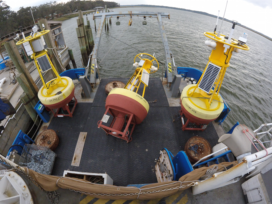
The aft deck of the RV Savannah with three CORMP buoy systems onboard. The CORMP team, along with the crew of the RV Savannah replaced and recovered buoy systems off Fripp Island, SC and Wrightsville Beach, NC. (Photo by Brett Bolton.)
UNCW Coastal Ocean Research and Monitoring Program (CORMP) maintains the moorings with funding from SECOORA and US IOOS. The buoys provide important near real time data that helps weather forecasters and Emergency Response Managers in the Carolinas decide the best way to respond to dangerous situations.
Michael Colby – the lead Forecaster for the NOAA NWS Weather Forecast Office in Wilmington NC – relies on the buoy’s critical information. “I use the CORMP [data] extensively to access the potential for coastal impacts due to incoming wave energy. . . . The data is utilized here at the NWS office in Wilmington, NC to gauge the potential for rip currents, dangerous shoaling of waves into shallow water zones, inlet and entrance wave turbulence, breaking wave heights in the surf-zone, and marine forecast out to 20 NM.”
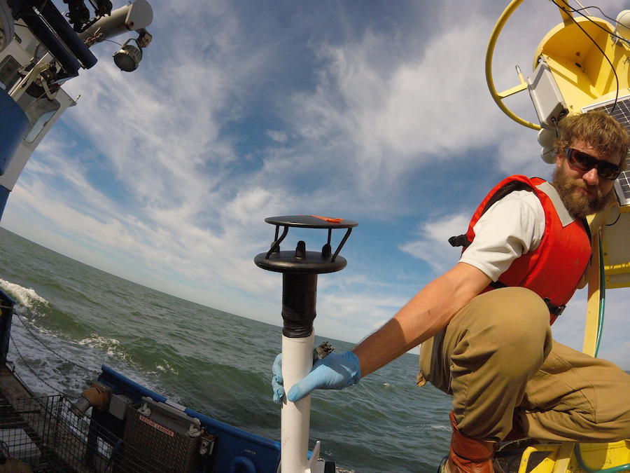
Brett Bolton displays a damaged Gill WindSonic anemometer from the ILM3 buoy. The damage most likely occurred as ILM3 observed Hurricane Mathew’s 60 kt gusts. (Photo by Chris LaClair.)
Some of the buoys were damaged during Hurricane Matthew. FRP2 buoy received damage to the halo and tower structure of the buoy. During the next few months the CORMP team will be working to repair and replace multiple anemometers, meteorological sensors and other buoy components. A special thank you to the fabrication shop and the Marine Tech Lab at UNCW’s Center for Marine Science for their support.
Twice a year the CORMP team recovers and deploys real-time oceanographic buoys off the coasts of North Carolina and South Carolina. The buoys are built and tested at the UNCW Center for Marine Science. The CORMP program is led by Dr. Lynn Leonard, Chair of the Department of Earth and Ocean Sciences, and has been providing oceanographic data and observations since 2000.
Watch this great video of Brett Bolton and Chris LaClair of CORMP, work with Michael Richter, Jordan Solomon, Zach Tait, Terrell Scarborough, Harry Carter and Captain Raymond Sweatte of the RV Savannah to deploy and recover the ILM3 buoy system and anchor.
Three buoys – FRP2, ILM2 and ILM3 – in the coastal waters of North Carolina and South Carolina were recovered and redeployed.
The aft deck of the RV Savannah with three CORMP buoy systems onboard. The CORMP team, along with the crew of the RV Savannah replaced and recovered buoy systems off Fripp Island, SC and Wrightsville Beach, NC. (Photo by Brett Bolton.)
UNCW Coastal Ocean Research and Monitoring Program (CORMP) maintains the moorings with funding from SECOORA and US IOOS. The buoys provide important near real time data that helps weather forecasters and Emergency Response Managers in the Carolinas decide the best way to respond to dangerous situations.
Michael Colby – the lead Forecaster for the NOAA NWS Weather Forecast Office in Wilmington NC – relies on the buoy’s critical information. “I use the CORMP [data] extensively to access the potential for coastal impacts due to incoming wave energy. . . . The data is utilized here at the NWS office in Wilmington, NC to gauge the potential for rip currents, dangerous shoaling of waves into shallow water zones, inlet and entrance wave turbulence, breaking wave heights in the surf-zone, and marine forecast out to 20 NM.”
Brett Bolton displays a damaged Gill WindSonic anemometer from the ILM3 buoy. The damage most likely occurred as ILM3 observed Hurricane Mathew’s 60 kt gusts. (Photo by Chris LaClair.)
Some of the buoys were damaged during Hurricane Matthew. FRP2 buoy received damage to the halo and tower structure of the buoy. During the next few months the CORMP team will be working to repair and replace multiple anemometers, meteorological sensors and other buoy components. A special thank you to the fabrication shop and the Marine Tech Lab at UNCW’s Center for Marine Science for their support.
Twice a year the CORMP team recovers and deploys real-time oceanographic buoys off the coasts of North Carolina and South Carolina. The buoys are built and tested at the UNCW Center for Marine Science. The CORMP program is led by Dr. Lynn Leonard, Chair of the Department of Earth and Ocean Sciences, and has been providing oceanographic data and observations since 2000.
Watch this great video of Brett Bolton and Chris LaClair of CORMP, work with Michael Richter, Jordan Solomon, Zach Tait, Terrell Scarborough, Harry Carter and Captain Raymond Sweatte of the RV Savannah to deploy and recover the ILM3 buoy system and anchor.
Related news
SECOORA Request for Proposals for a Data System Development, Operations, and Maintenance Service Provider
SECOORA seeks a Data System Development, Operations, and Maintenance (DMAC) service provider to act as a strategic partner while maintaining the current SECOORA Data System. Proposals are due to SECOORA by 5:00 PM ET, March 31, 2026.

Plankton Perfect: Using Imagery to Document Microscopic Marine Life
Dr. Enrique Montes is working to understand how plankton respond to changes in the ocean by capturing high resolution imagery with advanced technology. This work is funded by the Marine Biodiversity Observation Network (MBON) to use novel techniques like the Continuous Particle Imaging and Classification System (CPICS).

SECOORA Community Spotlight: Craig Harris
When Craig Harris signed on as the Emergency Management and Resiliency Coordinator for the city of Wilmington, North Carolina, he brought with him knowledge of water level sensors. SECOORA worked with Craig to install a water level sensor at the Love Grove Bridge in Wilmington, a site prone to flooding.