

Water Quality Monitoring Units Successfully Installed in the St. Lucie Estuary, Florida
Over the summer, five Land/Ocean Biogeochemical Observatory (LOBO) units have been installed in the Indian River Lagoon and St. Lucie Estuary on the east coast of Florida. The LOBO units provide real-time, high-accuracy and high-resolution water-quality data and archived data via a simple web-based interface. The deployments of the LOBOs is part of the Indian River Lagoon Observatory (IRLO) Program established by FAU's Harbor Branch, a SECOORA member.
Water quality in the Indian River Lagoon has changed considerably over the last century due to urbanization. The IRLO water quality network is designed to address emerging issues of environmental health in the IRL system by achieving a better understanding of the biodiversity and ecological functions of the lagoon and how they are impacted by the surrounding human population.
The deployed LOBOs are measuring temperature, salinity, dissolved oxygen, turbidity, CDOM (colored dissolved organic matter, or more simply, water color), chlorophyll (indicative of algae in the water column), nutrients (phosphate, nitrate), and current speed and direction. LOBOs can collect data 24/7 and allow real-time observation of significant events, such as water discharge, algal blooms, and storm events so that researchers can determine how these events are related to ecosystem change. Data from the LOBO units in the Indian River Lagoon will be integrated into the nationwide Integrated Ocean Observing System (IOOS) through SECOORA, allowing comparative studies both within Florida and in the nation (information found here).
A total of 9 LOBOs are expected to be installed along in the Indian River Lagoon. SECOORA is working with FAU to integrate the IRL data into SECOORA web site. The map to the right shows the proposed locations of the LOBOs. Click here to learn more.
Please contact IRL Principal Investigator - M. Dennis Hanisak,. at dhanisak@fau.edu for more information.
---
All images are credited to FAU
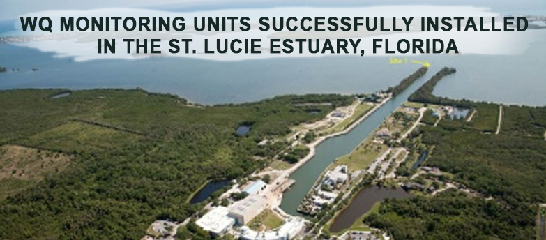
Over the summer, five Land/Ocean Biogeochemical Observatory (LOBO) units have been installed in the Indian River Lagoon and St. Lucie Estuary on the east coast of Florida. The LOBO units provide real-time, high-accuracy and high-resolution water-quality data and archived data via a simple web-based interface. The deployments of the LOBOs is part of the Indian River Lagoon Observatory (IRLO) Program established by FAU's Harbor Branch, a SECOORA member.
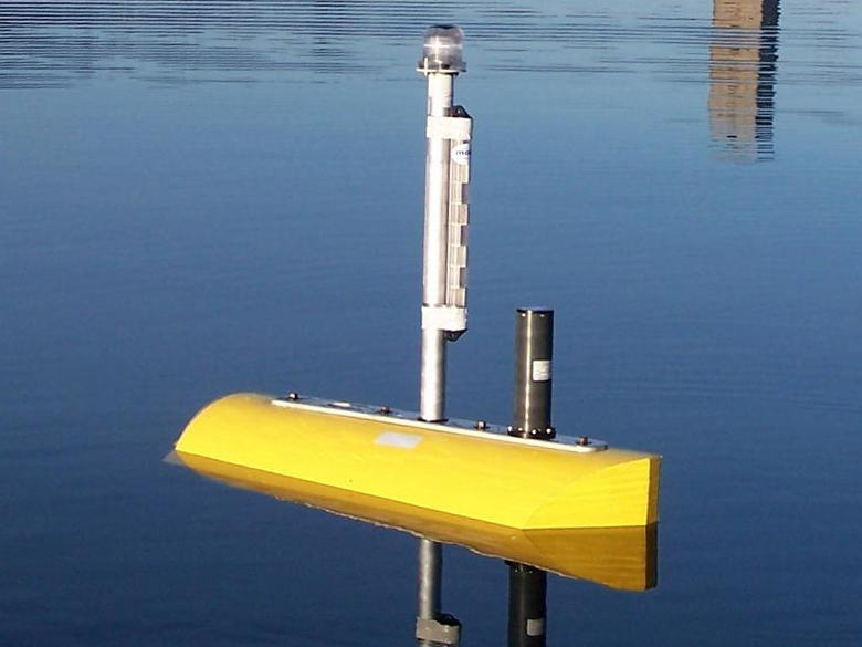 Water quality in the Indian River Lagoon has changed considerably over the last century due to urbanization. The IRLO water quality network is designed to address emerging issues of environmental health in the IRL system by achieving a better understanding of the biodiversity and ecological functions of the lagoon and how they are impacted by the surrounding human population.
.jpg)
The deployed LOBOs are measuring temperature, salinity, dissolved oxygen, turbidity, CDOM (colored dissolved organic matter, or more simply, water color), chlorophyll (indicative of algae in the water column), nutrients (phosphate, nitrate), and current speed and direction. LOBOs can collect data 24/7 and allow real-time observation of significant events, such as water discharge, algal blooms, and storm events so that researchers can determine how these events are related to ecosystem change. Data from the LOBO units in the Indian River Lagoon will be integrated into the nationwide Integrated Ocean Observing System (IOOS) through SECOORA, allowing comparative studies both within Florida and in the nation (information found here).
A total of 9 LOBOs are expected to be installed along in the Indian River Lagoon. SECOORA is working with FAU to integrate the IRL data into SECOORA web site. The map to the right shows the proposed locations of the LOBOs. Click here to learn more.
Please contact IRL Principal Investigator – M. Dennis Hanisak,. at dhanisak@fau.edu for more information.
—
All images are credited to FAU
Related news
Claire McGrath Joins SECOORA as Program and Development Manager
SECOORA welcomes Claire McGrath as Program and Development Manager, supporting the Southeast & Caribbean Coastal Disaster Resilience Partnership and membership growth.

Spotlight: Mobilizing to Save Florida’s Coral Reefs
Learn how scientists are racing to save Florida's Coral Reef through coral rescue, gene banking, reef restoration, and innovative conservation efforts after disease and marine heatwaves devastated one of America's most important marine ecosystems.
From a Whale’s Song to an Ocean’s Symphony: How AI Decodes Underwater Sound
Explore how SECOORA-funded research is using AI and machine learning to decode ocean soundscapes, detect boat noise, and support coral reef restoration efforts.