Updated November 11, 8:30 AM
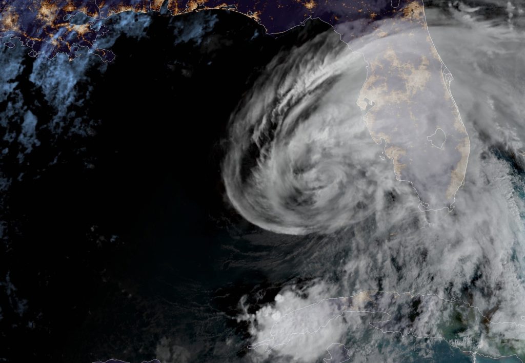
At 7:00 AM EST, Eta is moving toward the north-northeast near 15 mph (24 km/h), and this general motion is expected to continue through Thursday.
On the forecast track, the center of Eta will move closer to but offshore of the southwest coast of Florida today, approach the west-central coast of Florida tonight, and move inland over the northern portion of the Florida peninsula on Thursday. Eta is expected to move northeastward into the western Atlantic late Thursday or early Friday.
Eta is expected to be near or at hurricane strength tonight as it approaches the west coast of Florida, with rapid weakening expected after landfall on Thursday. Tropical-storm-force winds extend outward up to 115 miles (185 km) from the center. A University of South Florida COMPS buoy just southeast of Eta’s center recently measured a sustained wind of 49 mph (79 km/h) and a gust to 65 mph 104 (km/h).
Click for official updates from the NOAA National Weather Service National Hurricane Center.
SECOORA put together this page to highlight data and information related to the Tropical Storm Eta. It will be updated as new information becomes available and the track is more certain.
Please email communications@secooraorgpact.wpengine.com with additional resources to add!
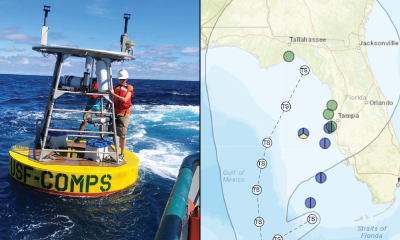
Buoy Data
Tropical Storm Eta’s projected path is expected to impact the southeast U.S. coast through early next week.
As the storm moves up the Florida coast, explore buoy data stations on the West Florida Shelf. The buoys are operated USF Coastal Ocean Monitoring and Prediction System
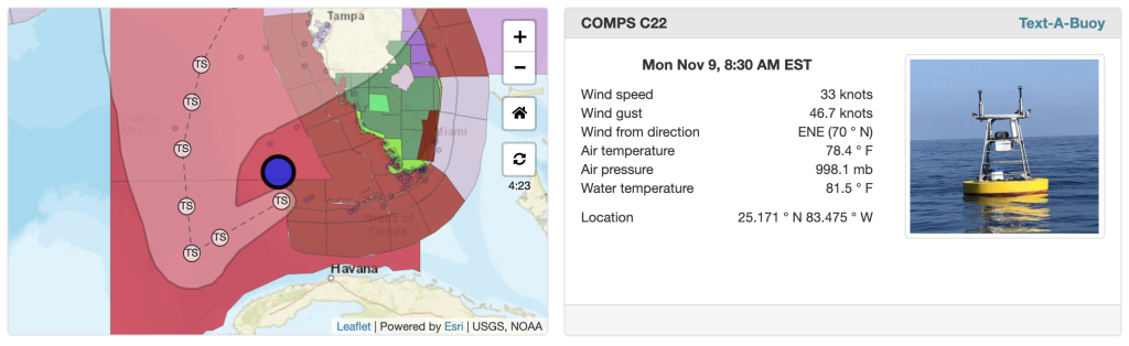
Buoy C22 reported wind gusts of 47 knots (54 mph) and wind speeds of 33 knots (38 mph). Click here for data.
Exploring Real Time Data
Explore Eta data with the SECOORA Marine Weather Portal (MWP). View real time weather hazards, tropical cyclone forecasts, and data from ocean and coastal observations as the hurricane approaches.
Follow the Data
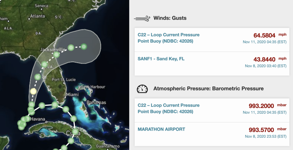
Eyes on the Storm pulls data from within 50 miles of Tropical Storm Eta path and showcases the highest wind speeds and wave heights and lowest barometric pressure. Assets in the storms path recorded a high wave heights and wind gusts off the coast of Florida. (pictured above).
Click here to follow the storm.
Integrated Data View of Eta

SECOORA’s Data Portal allows you to visualize Eta’s track with other datasets.
Pictured above is the SECOORA Data Portal displaying the NWS Hurricane track, SECOORA glider data, the NASA Sea Surface Temperature Analysis model, and real time sensors layers.
Access the SECOORA Data Portal
Fully Coupled Air-Sea-Wave Nowcast and Forecast
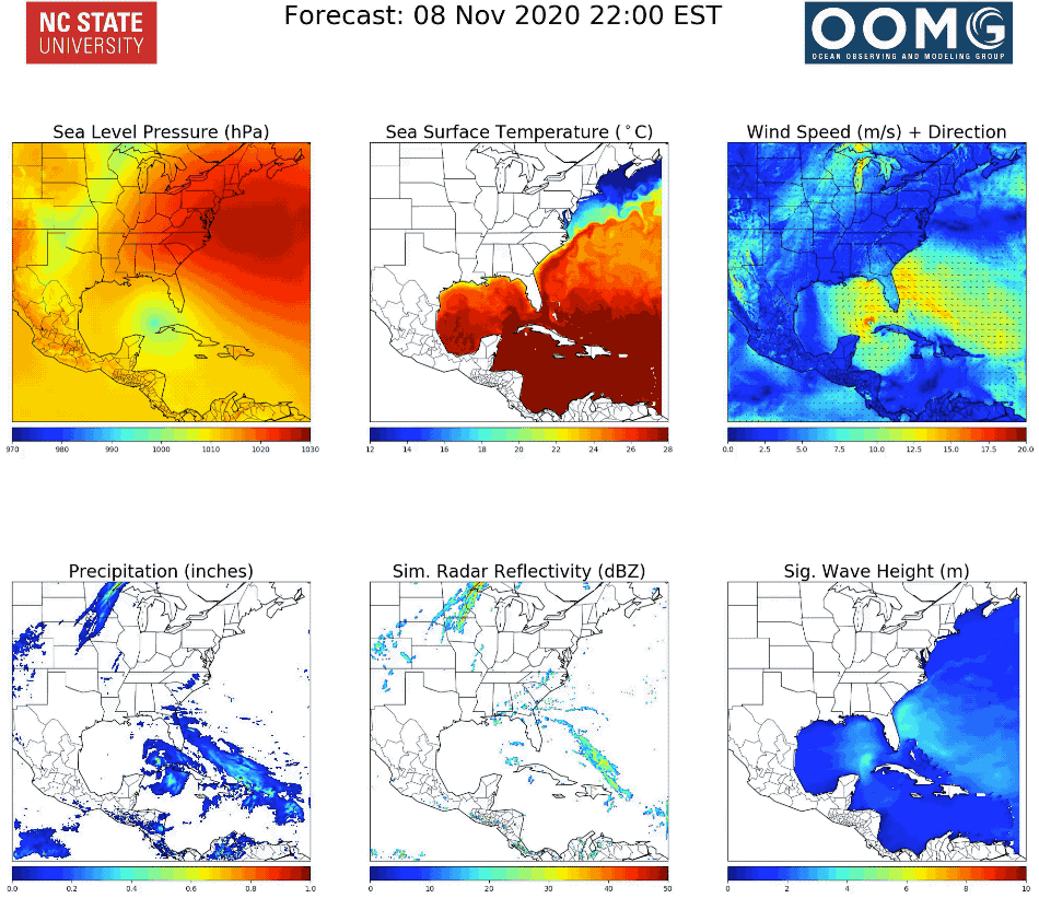
Check out current conditions and forecast of weather, ocean waves, and ocean currents as Eta moves through the West Florida Shelf.
The Coupled Northwest Atlantic Prediction System (CNAPS) is a three-dimensional marine environment nowcast and forecast system developed by the Ocean Observing and Modeling Group at North Carolina State University. This fully coupled ocean circulation, wave, and atmosphere model predicts ocean conditions based on real-time observations and computer programs.
More Hurricane Resources
Explore over 23 other hurricane data and other resources for the Southeast U.S. here.
Related news

SET Webinar Series: Partner Spotlight on the South Atlantic Salt Marsh Initiative
Join us on March 27, 2026, from 2:00 - 3:00 PM (ET) for the SECOORA SET Webinar Series where they will spotlight South Atlantic Salt Marsh Initiative (SASMI). This webinar will bring together SET Community of Practice members and partners to explore SASMI’s regional approach to salt marsh conservation and the role of scientific data in supporting restoration and coastal...

Abbey Wakely Joins SECOORA as Director of Communications and External Affairs
SECOORA welcomes Abbey Wakely as their new Director of Communications and External Affairs, where she will lead strategic engagement, communications, and external relations to strengthen the organization’s regional impact.
SECOORA Request for Proposals for a Data System Development, Operations, and Maintenance Service Provider
SECOORA seeks a Data System Development, Operations, and Maintenance (DMAC) service provider to act as a strategic partner while maintaining the current SECOORA Data System. Proposals are due to SECOORA by 5:00 PM ET, March 31, 2026.