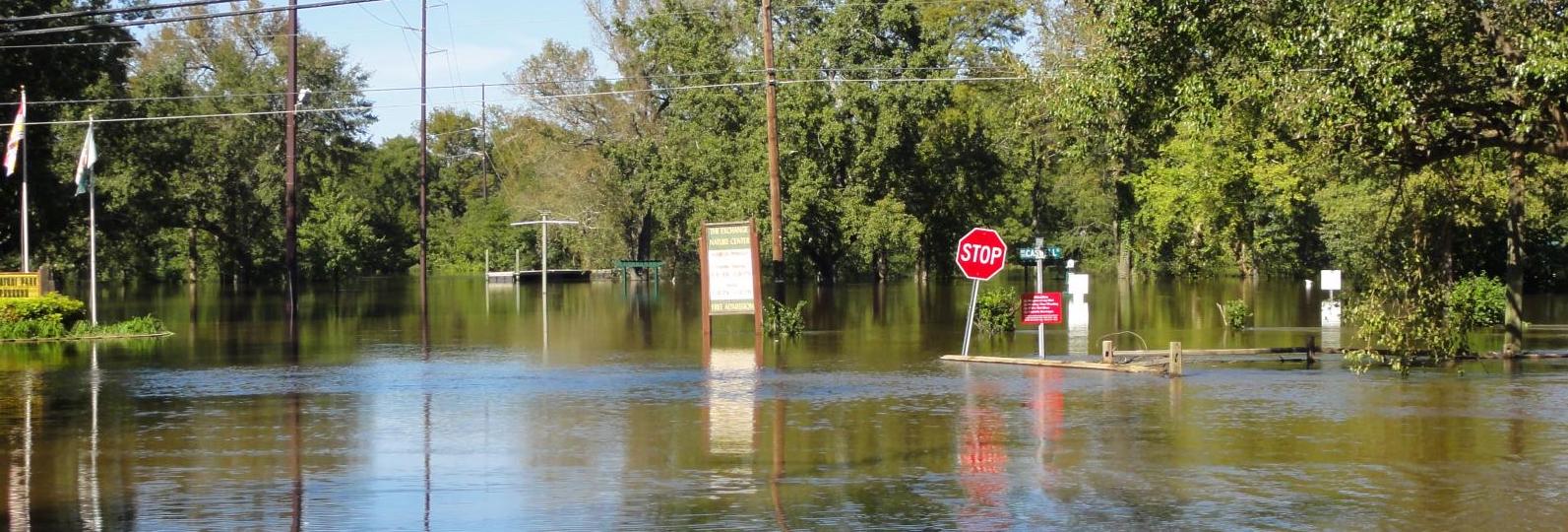
Flooding is a frequently occurring natural disaster that causes extensive damages to life, infrastructure, and the environment. It is critical to understand where flooding is occurring and know the depth of flood water, especially after major weather events.
A new project funded by the National Oceanic and Atmospheric Administration (NOAA) will use Unmanned Aerial Vehicle (UAV) imagery, satellite imagery, and machine learning methods to develop a more accurate and georeferenced 3D flood extent model. The project team includes members from North Carolina Agricultural and Technical State University (NC A&T), N.C. Department of Public Safety (NCDPS), NOAA National Weather Service, NOAA Southeast River Forecast Center, Axiom Data Science, and SECOORA.

Dr. Hashemi-Beni, N.C. A&T, lead Investigator for the project.
“Remote sensing data can provide much of the required information for delineating the flood-affected areas, assessing the damage (e.g., road, bridge, infrastructures), and feeding models that can predict the vulnerability to flooding of inland and coastal areas. Through this NOAA-funded project, we will leverage high-resolution remote sensing data, cloud computing and cutting-edge geospatial data analytic approaches to provide science-based information to decision-makers for flood resilience and mitigation. I am so excited about the opportunity to work with this strong team to contribute to solutions for flooding issues, the most destructive–natural hazard,” – stated Dr. Hashemi-Beni, N.C. A&T, lead Investigator for the project.
Collecting UAV Data
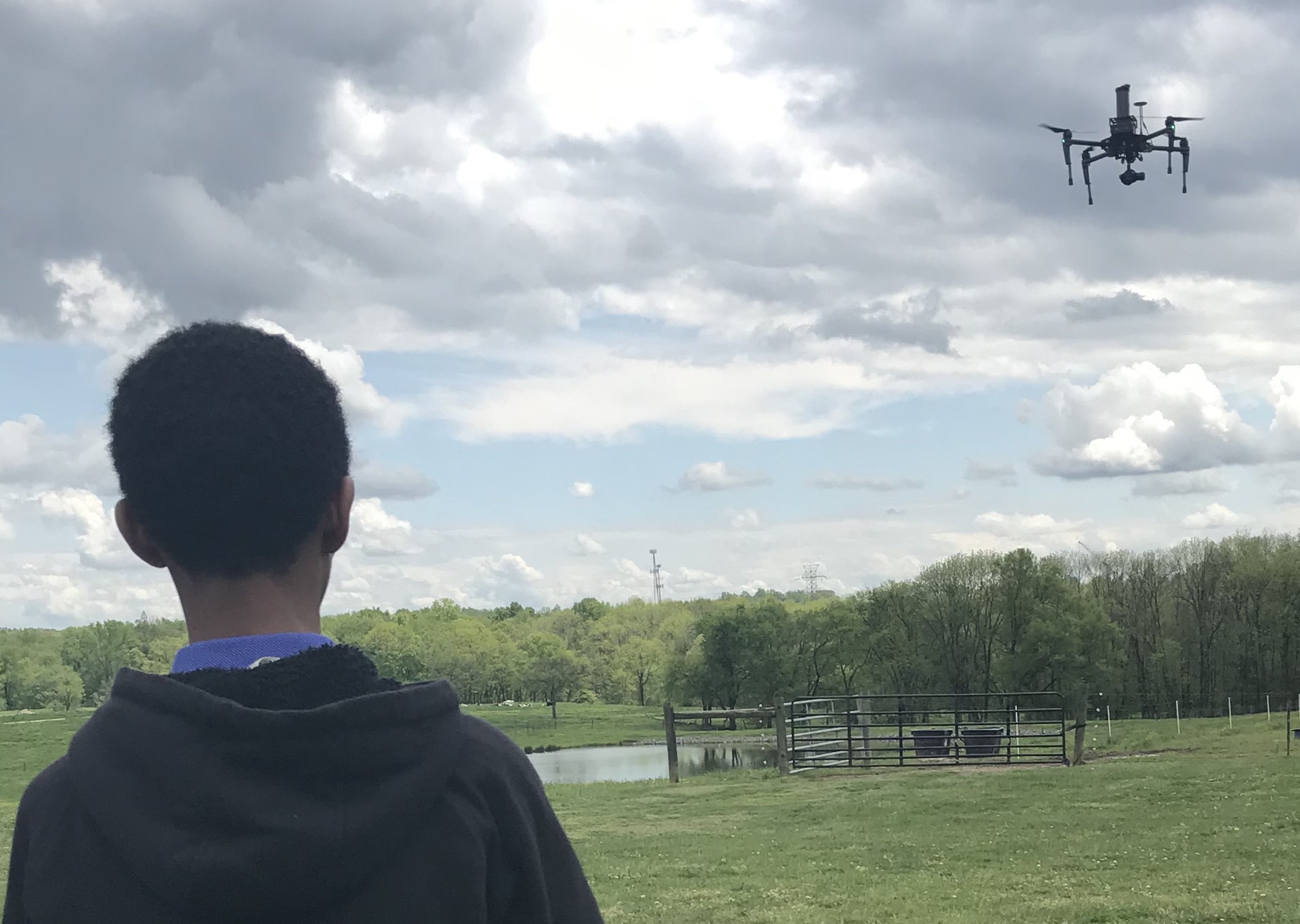
Using UAVs, project team members will conduct post weather event surveys. UAVs provide fast and accurate detection of inundated areas and can easily access hazardous environments that are otherwise inaccessible. They will capture images of the flood extent and flood water height using nearby Flood Inundation Mapping and Alert Network (FIMAN) gauge data and surveyed high water marks.
UAV and satellite data will be used to train and validate the flood extent model. Data collected during this project will be searchable and publicly-accessible through the SECOORA Data Portal.
Improving Natural Disaster Management Practices
North Carolina Emergency Management and NCDPS will use the project results to improve the natural disaster management practices. Emergency Managers will be able to identify locations where emergency services are most critical just after a flood event. The results will also provide the NWS with tools to evaluate existing flood inundation maps.
“This project will develop tools, techniques, and data that we can use to enhance our ability to become more resilient to flood events, assist impacted communities, and enhance recovery activities,” stated Gary W. Thompson, PLS Deputy Risk Management Chief.
Project Team
Dr. Leila Hashemi-Beni and research associate/postdoc and students from N.C. A&T will lead the project, including optical and synthetic aperture radar (SAR) data fusion, algorithm and model development, and sharing 2D and 3D flood extent and flood depth shapefiles.
Gary Thompson, PLS with NCEM , will lead the NCEM UAV Team and survey high water marks at research sites during flooding events.
Jennifer Dorton, SECOORA Deputy Director, will coordinate engagement with partners and assist with transition planning with the project team and NOAA.
Kyle Wilcox and Lauren Showalter from Axiom Data Science will lead data management efforts, including managing and sharing data generated during the course of this project.
Steve Pfaff and Rick Neuherz, NOAA NWS Wilmington Weather Forecast Office, will serve as NOAA collaborators who will evaluate the technical components of the 2D and 3D flood mapping products for USGS gauged and non-gauged rivers and coastal areas within their forecast area. The NWS Wilmington office will also survey flood areas post storm events to help ground truth 2D and 3D flood maps.
David Glenn and Ryan Ellis, NOAA NWS Newport/Morehead City Weather Forecast Office, will compare project flood maps with inundation maps provided through the Advanced Hydrologic Prediction Service and USGS flood gauge data within their forecast area. The NWS Newport/Morehead City office will also survey flood areas post storm events to help ground truth 2D and 3D flood maps.
John Schmidt, Southeast River Forecast Center, and Shawn Carter and KC Curry, NOAA’s National Water Center, will evaluate NCAT 2D and 3D flood maps for previous storms, Florence and Matthew, and flood events occurring during the project period. They will provide guidance on fusion of Synthetic Aperture Radar and optical data outputs and evaluate outputs in areas of dense vegetation where flood extent mapping is often difficult.
Related news

SECOORA Webinar: Collaborative Fisheries with a SMILE (Size Matters: Innovative Length Estimates)
On Tuesday, June 24th at 12 PM ET, Dr. Jennifer Loch from Reef Environmental Education Foundation (REEF) will discuss the SMILE (Size Matters: Innovative Length Estimates) project as part of SECOORA's Coastal Observing in Your Community Webinar Series.
Funding Cuts to NOAA IOOS Will Hurt the Southeast
Proposed federal funding cuts would eliminate the IOOS Regional Observations budget for next year. Contrary to the budget Congress has already approved for this year, the Executive Branch wants these proposed cuts to go into effect in 2025.
SECOORA Webinar on the Rapid Intensification of Hurricane Ian: Warm Subsurface Water on the Wide Continental Shelf
Join us Thursday, April 24th at 12 PM ET for the April installment of the SECOORA Coastal Observing in Your Community Webinar Series! This month, we will hear from Dr. Yonggang Liu from the University of South Florida. He will discuss his research on the rapid intensification of Hurricane Ian in relation to anomalously warm subsurface water on the wide...