SECOORA’s 2019 Data Challenge Winner, Matthew Conlin, a PhD student at the University of Florida, has developed an easy tool to remotely calibrate web camera images for use in measuring changes in coastal and nearshore environments.
Coastal webcams are a popular tool for observing wave and shoreline conditions at beaches throughout the southeast. Webcams are used for recreational activities, providing an easy way to check on surfing conditions, as well as for environmental research, such as identifying dune erosion after storm events.
While there are many advantages to using webcams, it is difficult to use the images to accurately (and easily) measure changes in coastal and nearshore environments. However, SECOORA’s 2019 Data Challenge Winner, Matthew Conlin, a PhD student at the University of Florida, has now developed an easy way to remotely calibrate cameras specifically for this purpose.
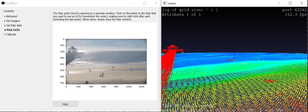
The Surf-camera Remote Calibration Tool, or SurfRCaT, developed by Conlin is an open-source tool that solves for camera parameters needed to transform webcam landscape images into bird’s-eye-view maps that are scaled and oriented. These maps allow the user to track coastal and nearshore geophysicial processes in real time and can be used, for example, to validate rip-current forecast models or augment existing coastal-zone monitoring activities.
SurfRCaT is an open-source, Python-based application that is available for unrestricted download through GitHub (github.com/conlin-matt/SurfRCaT). While the tool can be applied to most webcam data, specific options were built into SurfRCaT that focuses on the WebCAT web camera array. Along with the source-code, the SurfRCaT packet includes documentation and a step-by-step user guide. Below is a video on the tool.
Compiling these data, SurfRCaT then applies non-linear least-squares techniques to solve the parameters that are required to generate a final map-image. These maps come complete with relative directional distances from the point-of-origin, in meters, and can be used to easily make accurate measurements of environmental change and processes in the nearshore in real-time.
SurfRCaT only works on PC-based platforms; however, Conlin plans to expand this tool to operate on Mac and Unix-based platforms. Additionally, planned improvements include a tool to correct for lens distortion and an image rectification module.
Related news

Webinar | Preparing for Hurricane Season with SECOORA: Observing Systems, Data, and Tools
When a storm is approaching, having the right data matters. Join us on May 6 at 11:00 AM ET to explore how SECOORA’s observing systems, data, and tools can support hurricane monitoring and informed decision-making.
SET Webinar Series: Coastal Wetland Response in Apalachicola Bay
Join us on April 10, 2026, from 2:00 - 3:00 PM for the SECOORA SET Webinar Series, where we will explore coastal wetland change and monitoring in the Apalachicola Bay region. This webinar will bring together SET Community of Practice members and partners to examine monitoring approaches and implications for coastal resilience planning.

Funding Opportunity: Accepting Applications for 2026 Vembu Subramanian Ocean Scholars Award
Established in memory of Vembu Subramanian, this award supports the next generation of ocean professionals through mentorship, networking, and meaningful engagement at our Annual Meeting. Applications are due April 21, 2026.