Our Purpose
The SECOORA SET Community of Practice (CoP) aims to bring together individuals and organizations dedicated to coastal resilience. Our goal is to share knowledge, collaborate on initiatives, and enhance coastal management practices through collective effort.
Our Team
Nisse Goldberg
SET Coordinator
Bailee Porter
Student Assistant
SET CoP News

SECOORA Hosts the First Surface Elevation Table (SET) Community of Practice Virtual Workshop
The SECOORA SET Workshop was virtual on July 17, 2025. More than 50 Community of Practice members and stakeholders joined this collaborative workshop to discuss SET monitoring, coastal resilience, and data-driven decision making in the Southeast.
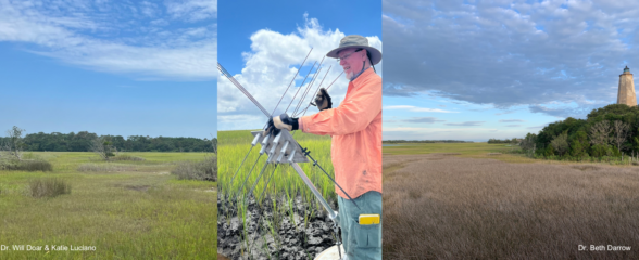
Meet the Winners of the Surface Elevation Table (SET) Call for Proposals
SECOORA hosted a request for proposals for the installation of new Surface Elevation Table (SET) stations or the reactivation of historic SET stations within the Southeast region. This opportunity covers the cost of materials and supplies for the stations. Meet the winners here!
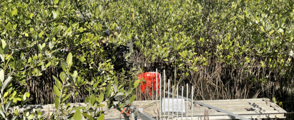
Call for Installation of New SET Stations and/or Reactivation of Historic SET Stations
SECOORA invites proposals for funding the installation of new Surface Elevation Table (SET) stations or the reactivation of historic SET stations within our region.
North Carolina
| Name | Affiliation | Contact |
|---|---|---|
| Jenny Davis | NOAA NCCOS | Jenny.Davis@noaa.gov |
| Elizabeth S. Darrow | Bald Head Island Conservancy | darrow@bhic.org |
| Charlie Deaton | North Carolina Dept. of Environmental Quality - Division of Marine Fisheries | Charlie.Deaton@deq.nc.gov |
| Michelle Moorman | U.S. Fish and Wildlife Service (FWS) | michelle_moorman@fws.gov |
| Justine Neville | U.S. Geological Survey (USGS) | jneville@usgs.gov |
| Rick Savage | Carolina Wetlands Association | Rick.savage@carolinawetlands.org |
| Marcelo Ardon Sayao | North Carolina State University (NCSU) | mlardons@ncsu.edu |
| Lori Sutter | University of North Carolina Wilmington (UNCW) | sutterl@uncw.edu |
| Christine Voss | University of North Carolina | c.m.voss.unc@gmail.com |
South Carolina
| Name | Affiliation | Contact |
|---|---|---|
| Tom Austin | Edisto Island Open Land Trust | land@edisto.org |
| Scott Curtis | The Citadel | wcurtis1@citadel.edu |
| Will Doar | South Carolina Department of Natural Resources (SCDNR) | DoarW@dnr.sc.gov |
| Courtney E. Kimmel | Port Royal Sound Foundation | ckimmel@portroyalsoundfoundation.org |
| Katie Luciano | South Carolina Department of Natural Resources (SCDNR) | LucianoK@dnr.sc.gov |
| Denise Sanger | South Carolina Department of Natural Resources (SCDNR) | SangerD@dnr.sc.gov |
| Erik Smith | University of South Carolina Baruch Institute | erik@baruch.sc.edu |
Georgia
| Name | Affiliation | Contact |
|---|---|---|
| Ben Carswell | University of Georgia - Carl Vinson Institute of Government | bcars@uga.edu |
| Lori Sutter | University of North Carolina Wilmington (UNCW) | sutterl@uncw.edu |
Florida
| Name | Affiliation | Contact |
|---|---|---|
| Jeremy Conrad | U.S. Fish and Wildlife Service (FWS) | jeremy_conrad@fws.gov |
| Mike Osland | U.S. Geological Survey (USGS) | mosland@usgs.gov |
| Ryann Rossi | St. Andrew & St. Joseph Bays Estuary Program | rrossi@fsu.edu |
| Ches Vervaeke | National Parks Service | william_vervaeke@nps.gov |
| Josh Breithaupt | Coastal & Marine Laboratory Florida State University | jbreithaupt@fsu.edu |
| Lynn Wingard | Emeritus USGS | lwingard.awg@gmail.com |
| Bethany Stackhouse | Florence Bascom Geoscience Center, US Geological Survey | bstackhouse@usgs.gov |
| Kara Radabaugh | Fish & Wildlife Research Institute, Florida Fish and Wildlife Conservation Commission | kara.radabaugh@myfwc.com |
| Annie Roddenberry | Aquatic Habitat Conservation and Restoration, Florida Fish and Wildlife Conservation Commission | Annie.Roddenberry@myfwc.com |
| Megan Lamb | Florida Dept. of Environmental Protection | Megan.Lamb@FloridaDEP.gov |
Other
| Name | Affiliation | Contact |
|---|---|---|
| Ryan P. Moyer | TerraCarbon LLC | ryan.moyer@terracarbon.com |