UM Rosenstiel School of Marine and Atmospheric Science adds Helicopter to Research Resources
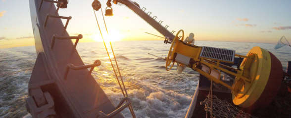
On April 13, 2015 the University of Miami’s Rosenstiel School added a commercial helicopter (Airbus Helicopter H125) to its research fleet. The helicopter observation platform (HOP) is equipped with advanced technology for studying critical physical, chemical and biological processes near the Earth’s surface.
With the capability to hover just above the surface, HOP is ideal for conducting different types of remote sensing observations, such as airborne sea-surface measurements. Fully fueled and with both pilot and co-pilot on board, the HOP can carry a scientific payload of up to about 1,000 lbs internally (about 3,000 lbs externally) and fly for nearly 4 hours without refueling at an airspeed of 65 knots, which is ideal for in-situ observations.
The airborne research laboratory is a unique tool that will fill critical gaps in chemical and biological observations of the environment. Read more here.
---
SECOORA funds Dr. Nick Shay (UM Rosenstiel School) to support four WERA radar arrays along the coast of Miami, Florida. High frequency (HF) radar systems measure the speed and direction of ocean surface currents in near real-time. Ocean surface currents are fundamental for spill response and search and rescue operations. UM Rosenstiel School of Marine and Atmospheric Science is a member of SECOORA. Become a member today!
Story adapted from University of Miami press release, “UM Rosenstiel School Unveils New Helicopter Observation Platform”
On April 13, 2015 the University of Miami’s Rosenstiel School added a commercial helicopter (Airbus Helicopter H125) to its research fleet. The helicopter observation platform (HOP) is equipped with advanced technology for studying critical physical, chemical and biological processes near the Earth’s surface.
With the capability to hover just above the surface, HOP is ideal for conducting different types of remote sensing observations, such as airborne sea-surface measurements. Fully fueled and with both pilot and co-pilot on board, the HOP can carry a scientific payload of up to about 1,000 lbs internally (about 3,000 lbs externally) and fly for nearly 4 hours without refueling at an airspeed of 65 knots, which is ideal for in-situ observations.
The airborne research laboratory is a unique tool that will fill critical gaps in chemical and biological observations of the environment. Read more here.
—
SECOORA funds Dr. Nick Shay (UM Rosenstiel School) to support four WERA radar arrays along the coast of Miami, Florida. High frequency (HF) radar systems measure the speed and direction of ocean surface currents in near real-time. Ocean surface currents are fundamental for spill response and search and rescue operations. UM Rosenstiel School of Marine and Atmospheric Science is a member of SECOORA. Become a member today!
Story adapted from University of Miami press release, “UM Rosenstiel School Unveils New Helicopter Observation Platform”
Related news

SECOORA Webinar: Collaborative Fisheries with a SMILE (Size Matters: Innovative Length Estimates)
On Tuesday, June 24th at 12 PM ET, Dr. Jennifer Loch from Reef Environmental Education Foundation (REEF) will discuss the SMILE (Size Matters: Innovative Length Estimates) project as part of SECOORA's Coastal Observing in Your Community Webinar Series.
Funding Cuts to NOAA IOOS Will Hurt the Southeast
Proposed federal funding cuts would eliminate the IOOS Regional Observations budget for next year. Contrary to the budget Congress has already approved for this year, the Executive Branch wants these proposed cuts to go into effect in 2025.
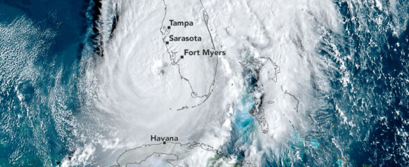
SECOORA Webinar on the Rapid Intensification of Hurricane Ian: Warm Subsurface Water on the Wide Continental Shelf
Join us Thursday, April 24th at 12 PM ET for the April installment of the SECOORA Coastal Observing in Your Community Webinar Series! This month, we will hear from Dr. Yonggang Liu from the University of South Florida. He will discuss his research on the rapid intensification of Hurricane Ian in relation to anomalously warm subsurface water on the wide...