The University of South Florida’s Coastal Ocean Monitoring and Prediction System (USF COMPS), recently installed new high frequency radar (HF radar) in Key West’s Smathers Beach Park.

The new Key West CODAR SeaSonde® HF radar is the second of three CODAR HF radars to be deployed in the lower Florida Keys region to measure surface currents. The three HF radars will help improve the understanding and prediction of the Gulf of Mexico Loop Current.
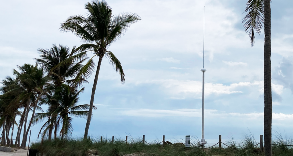
Installation of the Key West site (called WEST), located in Smathers Beach City Park, was completed in late December of 2022 (Figure 1). Data from this site as well as all of the HF radars in the southeast flow to NOAA’s Integrated Ocean Observing System Coastal Observing Research and Development Center (CORDC). USF COMPS plans to install a third HF radar within the Dry Tortugas National Park. Deployment is anticipated before the end of 2023 or early 2024.
HF radars are land-based systems that measure the speed and direction of ocean surface currents in near real-time. Surface currents can move objects in the ocean such as boats, marine debris, and nutrients. HF radar systems transmit radio signals across the ocean. These radio signals bounce off of ocean waves and signals are scattered back to the coast where they are picked up by the radar’s receive antennae. Through thorough analysis of the returned signals, estimations of surface current speed and direction are derived (Figure 3).
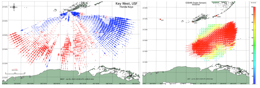
For accurate calculations of surface current speed and direction, it is necessary for the radio signals from one HF radar system to overlap with signals from another independent HF radar system. Currently the data obtained from the HF radar system at WEST is being merged with MARA HF radar data. The MARA HF radar system was installed within Curry Hammock State Park near Marathon, FL in December 2019. The two HF radars work together to provide real-time surface current maps within the complex Straits of Florida.
Applying Innovative and New Technology
A unique feature of the WEST HF radar is the installation of a new CODAR SeaSonde® low frequency 5 MHz Transmit/Receive (TR) antenna design that serves as both the transmit and receive antenna. Unlike traditional HF radar low frequency installations which use two separate antennas, this new and innovative single 5 MHz TR antenna design minimizes environmental disturbance in the sensitive areas of Key West’s Smathers Beach Park, overcomes limited access to communications and electrical infrastructure, and provides data for areas that were previously difficult to monitor because of limited available coastal land frontage or site usage constraints. The new single low frequency 5 MHz TR antenna being used at Smathers Beach Park is the first to go into operational use.
Normally during HF radar installations, one transmit antenna and one receive antenna are installed approximately 100 meters apart to disburse and collect the radio signals. A transmit antenna disburses radio signals oceanward and a receive antenna picks up the back scattered radio signals. This information is analyzed to estimate surface current speed and direction.
Dr. Cliff Merz, lead Principal Investigator from USF COMPS, notes that “consistent data products from each of these HF radars, when combined with other real-time observations, will provide valuable insight and enable a better understanding of the complex and variable surface outflow regions of the Loop Current System through the Straits of Florida.”
Data Made Possible
Funding for this project was provided through an award from the National Academies of Sciences, Engineering, and Medicine Gulf Research Program (NASEM-GRP) as well as support from USF’s College of Marine Science. NASEM-GRP funds long-term research projects to improve the understanding and prediction of the Gulf of Mexico Loop Current System. This project is part of a larger Gulf of Mexico Loop Observing Partnership including Texas A&M University, the University of Southern Mississippi, The University of Miami, Rutgers University, and Gulf of Mexico Ocean Observing System.
The HF radar installation is made possible by many partnerships. Thank you to the City of Key West, Florida Institute of Oceanography’s Keys Marine Laboratory, CODAR Ocean Sensors, Ltd., Perez Engineering and Development, Inc., Arlington Electric South, Inc. and Keys Community Construction, LLC for providing support for the project. To learn more, please contact Dr. Merz at cmerz@usf.edu.
Related news
SECOORA Hosts the Second Surface Elevation Table (SET) Community of Practice Workshop In Person in Charleston
The 2nd SECOORA SET Workshop convened in person on July 16-17, 2026 in Charleston, SC. More than 30 Community of Practice members and stakeholders joined this collaborative workshop to discuss SET monitoring, coastal resilience, and data-driven decision making in the Southeast.

Claire McGrath Joins SECOORA as Program and Development Manager
SECOORA welcomes Claire McGrath as Program and Development Manager, supporting the Southeast & Caribbean Coastal Disaster Resilience Partnership and membership growth.

Spotlight: Mobilizing to Save Florida’s Coral Reefs
Learn how scientists are racing to save Florida's Coral Reef through coral rescue, gene banking, reef restoration, and innovative conservation efforts after disease and marine heatwaves devastated one of America's most important marine ecosystems.