

Rebuilding the Future: USF’s College of Marine Science Recovers from Historic Blaze One Day at a Time

By Zoraida Díaz
The day before a lightning strike ignited a fire that severely damaged the University of South Florida’s (USF) Marine Science Lab (MSL), the dean of the College of Marine Science (CMS), Tom Frazer, was celebrating the end of another spring semester with faculty and students on the peninsula in Bayboro Harbor.
Since then, Dean Frazer has often reflected on that joyous day: “The strength of our community and the memories of our time together have helped me through difficult situations over the past few weeks.”
It took 200 firefighters and 60 fire vehicles to put out the May 2nd blaze that severely damaged the 80,000-square-foot, 87-year-old building. Because firefighters had to use saltwater to combat the fire, many sophisticated instruments were damaged.
The USF Campus Response Team’s crisis management protocols were activated even before the flames were out. Kevin Sullivan, USF’s Emergency and Safety Manager and former U.S. Coast Guard officer, led emergency efforts focused on saving lives. “Number one is nobody gets hurt,” Sullivan said. “Number two is how quickly can we get back to the primary mission, which is teaching and research.”
Once everyone was accounted for, Thomas Smith, USF St. Petersburg’s Interim Regional Chancellor and Vice Provost of Academic Affairs, and other response team members redirected their efforts to securing what could be salvaged.
“Soon, we were pulling freezers out. Samples were viable. We got those servers,” Smith recounted. “Pretty quickly, there was a way to see the path forward, and that was extraordinary.”
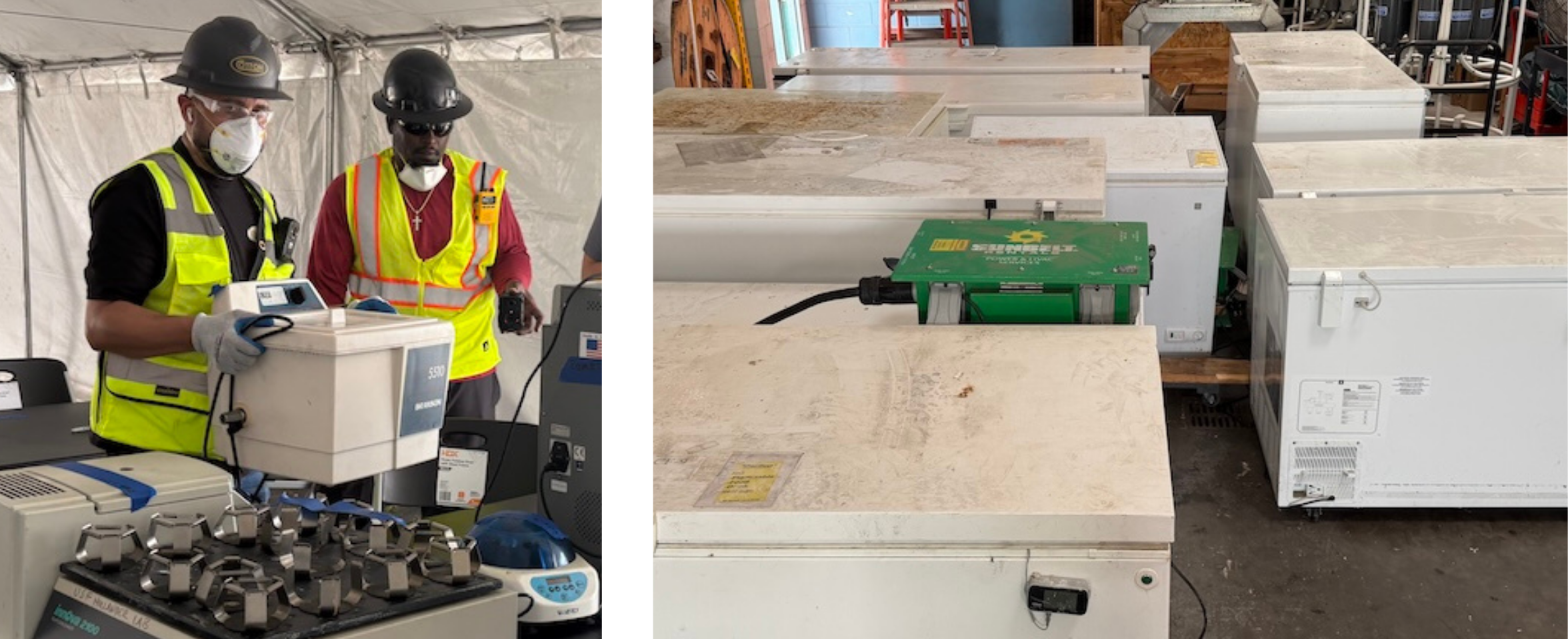
Within a few days, in partnership with the school’s Environmental Health and Safety Department, CMS researchers recovered 11 critical servers, essential technologies such as ocean gliders, and 37 freezers containing vital samples gathered over decades—some from as far away as Antarctica. Although 10 servers were back online almost immediately and 34 freezers were found to be fully operational, the viability of the frozen samples and ocean instruments remains uncertain.
In the aftermath, hundreds of items were recovered from various labs and set out in staging areas in the parking lot behind the MSL building—from personal belongings to decades’ worth of scientific archives.
The Personal Cost
The work and personal lives of scientists like Dr. Chuanmin Hu, Distinguished University Professor and director of the Optical Oceanography Lab, and an expert on Sargassum research, were severely disrupted.
“Literally, it is my second home. Excluding sleeping time, I perhaps spent more time in the MSL than in my own home,” said Dr. Hu, who had studied and worked in the building since 1998.
The viability of Dr. Hu’s Sargassum samples, stored in a rescued freezer, is still in question. What is certain is that Dr. Hu’s fieldwork will be significantly delayed. “My Sargassum remote sensing work is pretty much intact,” noted Dr. Hu, “but my wet lab was in that building, with all the instrumentation in it.”
Chad Lembke, Assistant Research Professor and the Ocean Technology Group’s (OTG) Lead Project Engineer, who was working as recently as this week in salvaging equipment from the wreckage, acknowledges it is a lot to digest: “It’s tough. I’ve worked in that building for 28 years…I’m going to miss it.”
Not everyone was a veteran occupant of the MSL. Luke McEachron, PhD, the new Associate Director of the Visualization Center at the CMS, had only recently moved into an MSL office. He brought with him items of sentimental value, such as books, awards, diplomas, and pictures that had accompanied him throughout his career.
“They were able to find a couple of boxes of my things, but everything was moldy and destroyed,” said Dr. McEachron.
A Hub Undone
The MSL was more than a building; it housed high-tech labs specializing in marine disciplines, such as Environmental Chemistry, Optical Oceanography, Electron Microscopy, and Genomics. As the central hub for physical oceanography at USF, it served as the operations center for the Ocean Circulation Lab (OCL), which manages ocean-monitoring networks and hosts critical servers that process real-time data from buoys and High Frequency (HF) Radar sites.
Dr. Steve Murawski, Research Professor and St. Petersburg Downtown Partnership Endowed Chair of Biological Oceanography and Director of the Center for Ocean Mapping and Innovative Technologies (COMIT), hosted by the CMS, acknowledges that one of the biggest challenges has been maintaining multi-system operations and research continuity for more than 150 researchers and students.
Those challenges are being met with the generous support from the scientific and St. Petersburg communities, which has shored up the long road to recovery.
“NOAA is going to accommodate me, my students, and others, and the St. Petersburg Innovation District has a building called “the Hub” [the Maritime and Defense Technology Hub] that has taken some of our people as well,” Murawski said during an interview with a local television station. “Some of the OTG and COMIT groups will be sharing space at The Hub with researchers from the Ocean Circulation group.”
Recovery efforts have also been complicated by the timing of the fire, which occurred just as the Florida Legislature was finalizing the 2026–2027 state budget. As a result, lawmakers were unable to allocate immediate emergency funds to rebuild.
In a message to the university community, USF President Moez Limayem noted that the university is still assessing the damage and navigating the insurance process: “As we gather more information, we will continue our discussions with legislators going into next year’s session.”
Meanwhile, the scientific and neighboring communities have raised over $400,000, and the USF Foundation has launched the Marine Science Operating Fund to support CMS’s immediate operations.
Saving EMMET
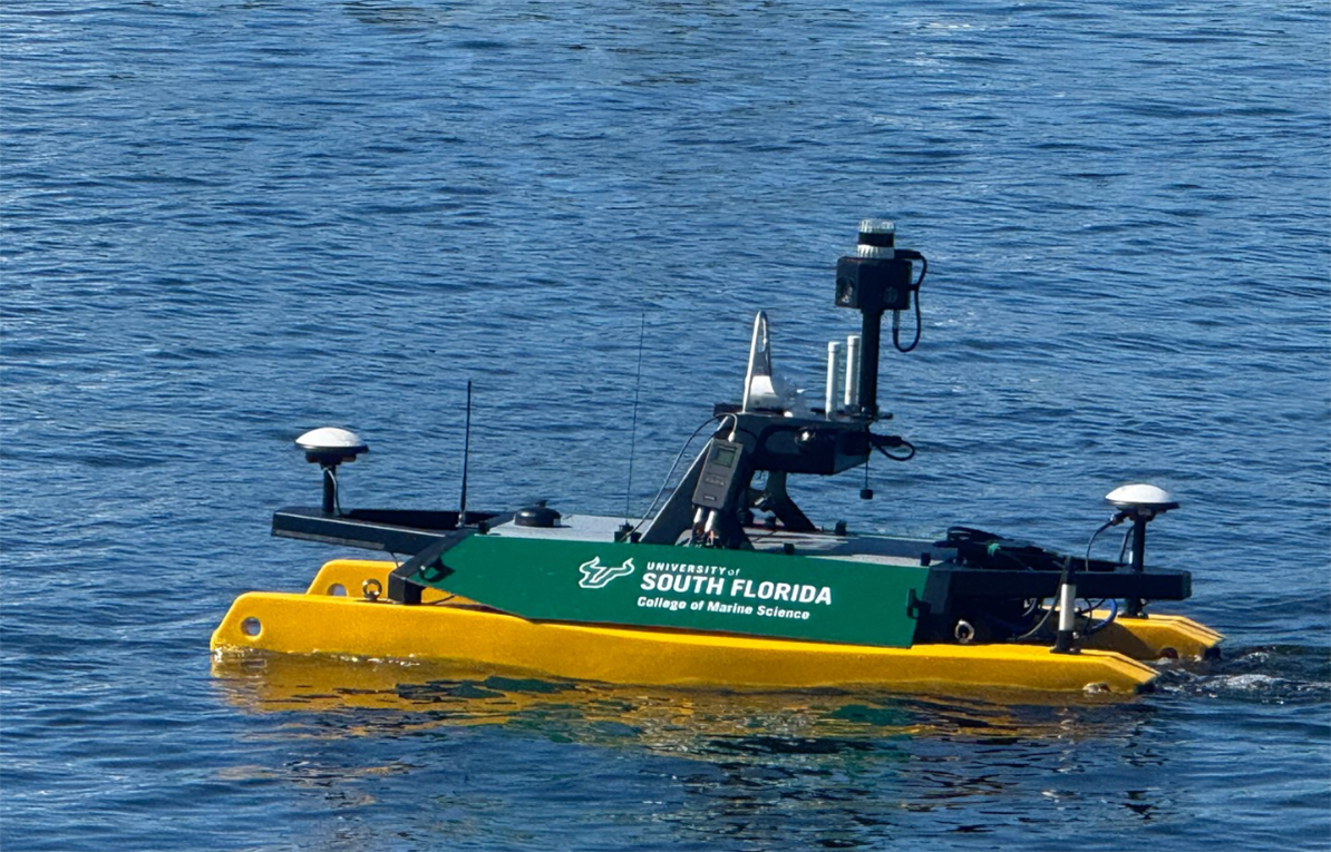
Most recently, additional areas of the college’s Ocean Technology Group (OTG) lab space were cleared for salvage operations. Researchers from OTG, who support collaborative initiatives like COMIT, have been working overtime to extract the Autonomous Surface Vehicles (ASVs) from the ruins of the building—including the Otter-class uncrewed surface vehicle EMMET (Enhanced Mobile Mapping with Emerging Technologies).
Acquiring EMMET was the result of an exciting collaboration between COMIT and the state-funded Florida Flood Hub for Applied Research and Innovation (the Flood Hub).
Measuring over six feet long (2 m) and 3 feet wide (1.1 m), the 1-year-old EMMET was outfitted with state-of-the-art technologies. These included a multibeam swath-mapping sonar, multiple GPS systems, four cameras providing a 360-degree view, and LiDAR, which emits laser pulses to help the ASV avoid collisions. A bare-bones model, manufactured by the Norwegian firm Maritime Robotics, whose technology supports NATO naval defense operations, starts at $30,000 to $50,000, with the cost climbing into the six figures once outfitted.
Dr. Murawski lauded the robotic vehicle’s capabilities in shallow waters when testing it last November: “This sort of technology can allow us to do storm surge modeling and visualize how flooding might impact critical infrastructure.”
As of yet, EMMET’s fate is still unknown.
Of Red Tides and Whales
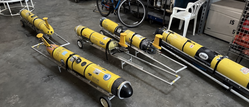
Five of the seven gliders comprising USF’s glider fleet were extracted from the destroyed MSL building.
“One [glider] got thrown off the table it was on, and the other was buried in debris from the roof failure,” said Lembke, referring to the two fully active gliders that were awaiting deployment when the fire happened. Although they are both operational, it is not yet known if they’ve suffered internal damage.
As fortune would have it, two gliders were out at sea in different missions at the time of the fire. One was part of a long-term collaboration with the Florida Fish and Wildlife Research Institute’s Harmful Algal Bloom/Red Tide Task Force. The glider, which transits along the West Florida shelf, collects subsurface water data to help understand and predict red tides.
The second glider was on a Gulf of America Coastal Ocean Observing System (GCOOS)-funded mission, which seeks to strengthen collaborations with the University of Southern Mississippi and Texas A&M University. Mission goals included collecting passive acoustic data within Rice’s Whale habitats while working with the GCOOS data team and the sensor manufacturer (Loggerhead Instruments) on auto-recognition algorithms to provide crucial information on the animal’s migration and movement patterns. The Rice’s Whale is a newly identified, elusive species that inhabits the northeastern Gulf. The rare mammals have been sighted along the continental shelf break at depths of 300 to 1,300 feet (about 100-400m).
Servers, Buoys, and Radars
“Most of the Ocean Circulation Lab (OCL) members’ offices, mooring lab, water quality lab, and computer server room were located in the MSL,” said Associate Professor and Director of the OCL, Dr. Yonggang Liu.
The buoy and mooring equipment, along with the data servers recovered during the initial rescue efforts, are vital to coastal monitoring and circulation modeling. “We are glad to share that our real-time data delivery is up and running,” said Dr. Liu, “and our numerical model nowcast/forecast systems were restored for automated running within several days.”
The Coastal Ocean Monitoring Prediction System (COMPS), housed within OCL and funded by the Southeast Coastal Ocean Observing Regional Association (SECOORA), operates an extensive network of offshore buoys, subsurface moorings, and High Frequency (HF) Radar sites. Shortly after the fire, the COMPS team recovered critical instrumentation from the ruined building.
“We were able to recover our original servers and hook them up in a different location, and when repowered, they came back up and worked as before,” said Dr. Clifford Merz, the COMPS Program and HF Radar Operations Director.
Dr. Merz confirmed that all six HF Radar sites were back up and reporting to HFRNet, the national “super-highway” for radar data managed by NOAA and the Integrated Ocean Observing System (IOOS).
Jay Law, physical oceanographer and mooring technician with the college, coordinated the servicing of the buoys during a crucial pre-hurricane research cruise less than three weeks after the fire. He credited the USF community with uncommon resilience: “The students and staff from the operations team have worked tirelessly to dig out, move, and set up a new lab space, all while working to stay on a busy field schedule.”
The COMPS team has remained on schedule with field work, completing annual pre-hurricane season servicing of real-time buoys C10, C13, and C22, and non-real-time bottom stations C11, C15, and C19 (underwater monitoring instruments anchored to the seafloor that record months of baseline data that have to be manually retrieved).
The COMPS offshore buoys are key oceanographic and meteorological monitoring stations integrated into NOAA’s National Data Buoy Center (NDBC) network.
The buoys serve different functions depending on their location and purpose. For instance, buoy C13 is located on the West Florida Shelf, south of Tampa Bay, at a water depth of 164 feet (50 meters). One of its vital roles is to provide real-time subsurface water-temperature profiles. This metric is used to calculate ocean heat content in the Gulf, which is used to predict whether an approaching hurricane will intensify before making landfall in Florida.
Buoy C22 sits further south and west, at a depth of 230 feet (70 meters), and monitors the Loop Current—the powerful, warm ocean current that flows north into the Gulf and exits through the Florida Straits. At times, the current can spin off massive eddies of warm water that can fuel hurricanes or alter the region’s red tide blooms.
The NDBC historical databases show that C13 has been accumulating data and feeding the models since 2004, while C22 is a fresher newcomer, recording current profiles since 2019.
Hurricane Forecasting
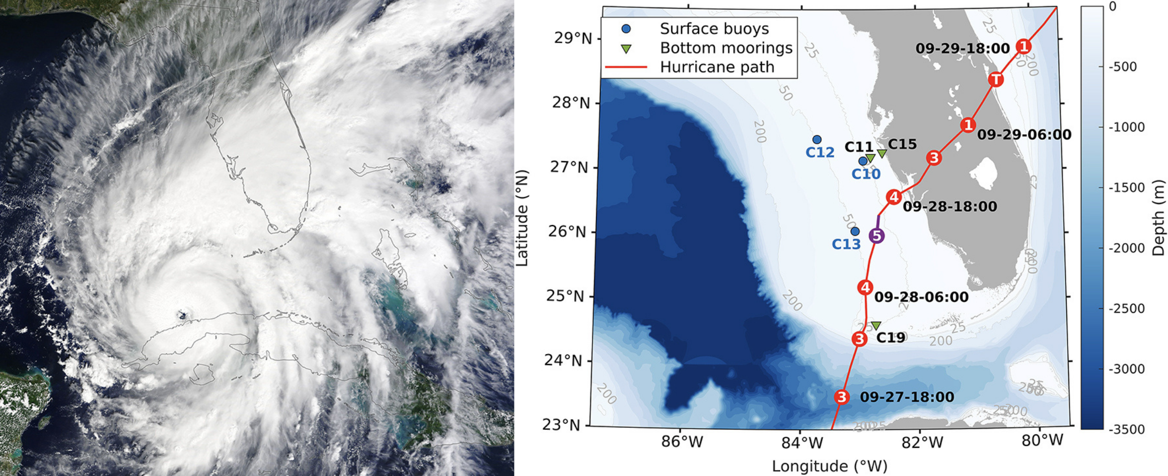
After proving highly accurate over past hurricane seasons, the OCL’s predictive models—and the offshore buoys that feed them—have demonstrated their inordinate value by successfully forecasting major storm surge across Tampa Bay and the Gulf.
“We first predicted water levels three days in advance during Ian, in 2022,” said Dr. Liu. “We did the same for Idalia and Helene.”
In 2022, as Hurricane Ian advanced on the west coast of Florida, Dr. Liu, monitoring the systems from his home in St. Petersburg, saw the models accurately predict that Ian would push water out of Tampa Bay, while farther south there would be a significant storm surge.
In 2025, lead author Dr. Liu published a study identifying a probable cause of Ian’s rapid intensification from a Category 3 storm to a Category 5 over 24 hours. The study found that because the strong Loop Current failed to reach a critical pressure point in the Gulf, it didn’t trigger the typical upswelling of deep, cold water. With subsurface waters along the West Coast of Florida remaining unusually warm, Ian intensified over the usually cooler shallow West Florida Shelf. Data gathered over decades by the COMPS team from buoy arrays and other instruments contributed greatly to the findings.
The 2026 hurricane season is underway, and Dr. Liu and the OCL scientists are already providing response agencies with crucial data, despite the many obstacles in the aftermath of the MSL blaze.
“According to the real-time data from our COMPS buoys, the subsurface temperature on the West Florida Shelf is higher than normal by about 2 degrees Celsius at this time of year,” Dr. Liu says.
“This is not good news for the Gulf Coast.”
Rebuilding Vital Networks
It is difficult to grasp the sheer scale of the groundbreaking research that took place in the MSL building, or the extent of the interdependent networks that sustained the work of hundreds of students, faculty, and staff. The loss is deeply felt, reverberating far beyond the St. Petersburg campus.
“We’re forecasting things like harmful algal blooms. We’re looking at the consequences of environmental change on extracted resources or exploited resources,” Dean Frazer told local media.
“We provide information that’s of value to our ports and our maritime industry. We have a tremendous impact on what we would call the blue economy, and so that’s very, very important to Florida and certainly to the nation as a whole.”
Related news

Dave Wells Joins SECOORA as Ocean Observing Systems Team Lead
SECOORA welcomes Dave Wells as Ocean Observing Systems Team Lead where he will oversee SECOORA's coastal observing system assets and data management.
At the Water’s Edge: Lowcountry Coastlines in a Brave New World
A nor'easter's record storm tide. A stalled tropical storm. Two Lowcountry towns adapting to a new era of flooding, with SECOORA data in hand.

Above the High Tide: Water Level Sensors on the Front Line
SECOORA's Southeast Water Level Network has installed 100+ sensors across the Carolinas, Georgia, and Florida, giving communities real-time flood data.