

Saving the North Atlantic Right Whale: Underwater Gliders Join the Fight to Save a Species
Meet the SECOORA-funded scientists using underwater gliders and acoustic tech to protect critically endangered North Atlantic right whales.
By Zoraida Díaz
Three hundred years ago, 5 million whales may have roamed the oceans. A landmark 2015 study estimated that in the 20th century alone, 2.9 million whales were killed by industrial whaling. Among those, some distinct species—including the North Atlantic right whale (Eubalaena glacialis)—were hunted to the brink of extinction. Scientists believe 100 to 300 specimens were left after commercial whaling was banned in 1935. Now, there are about 380 right whales, with only about 70 breeding females left. In 2020, the species’ status was updated to critically endangered.
“They were named the ‘right whale’ because they were the right whale to hunt,” says Dr. Erin Meyer-Gutbrod, an assistant professor in the School of the Earth, Ocean and Environment at the University of South Carolina. “Right whales live very close to shore, have large amounts of fat, and float when dead; these traits made them highly desirable for whalers.”
Meyer-Gutbrod has been studying right whales since her doctoral studies at Cornell University. “I started with modeling work to understand their demography and their threats, and especially how climate change impacts both their demography and their exposure to risk.” By analyzing right whale sightings from 1990 to 2018 to examine patterns in habitat use, Meyer-Gutbrod found that both human-caused and natural climate change affected the whales’ foraging habitats and migration, and reduced their use of Southeast calving grounds in Winter.
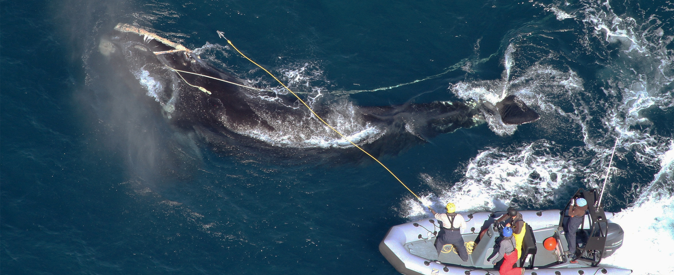
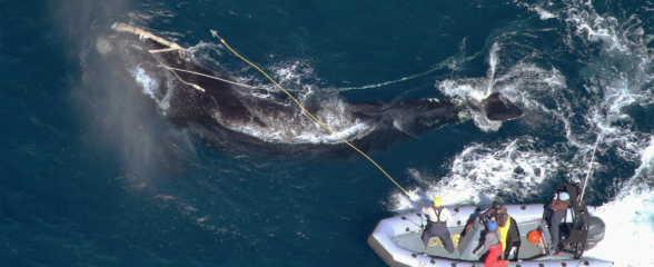
Today, the North Atlantic right whale is vulnerable to changing climate patterns affecting its food supply and birthing rates, and human-inflicted—and often lethal—vessel strikes and entanglements from fishing equipment.
Through research, stronger regulatory frameworks, and innovative uses of new technology, Dr. Meyer-Gutbrod and Dr. Catherine Edwards, Associate Professor of Coastal Physical Oceanography and Marine Robotics at the Skidaway Institute of Oceanography, are fighting to protect the critically endangered right whale.
Feeding the Right Whale
An adult right whale is 52 feet long and can weigh 140,000 lbs. It needs to consume 500 million to 1 billion copepods (Calanus finmarchicus and Calanus hyperboreus) per day, or about 2,500 lbs, or 1 to 2 tons of multicellular organisms that measure 1.5 to 3 millimeters, have a single eye, and use antennae to move through the water column. For pregnant or lactating females, this requirement doubles to over 2 billion.
Right whales feed on immense concentrations of copepods in traditional feeding areas like the Gulf of Maine and Bay of Fundy between April and October. These massive swarms are driven by tidal dynamics, which trap copepods in narrow channels, and upwelling, where deep ocean currents sweep along continental slopes, pushing nutrients and prey toward the surface.
Whales swim through these patches with their mouths open, using the hair-like fringes on their baleen plates to filter millions of copepods from the water. If the copepods descend into deep-water basins, whales make 5- to 15-minute feeding dives to depths up to 574 feet (175 meters).
A primary decline in copepods in traditional feeding areas like the Gulf of Maine and Bay of Fundy is due to shifts in major Atlantic Ocean currents, such as the Gulf Stream, which have moved northward, sending warmer, high-salinity slope water through deep channels like the bottom of the Gulf of Maine. Because C. finmarchicus spends late summer and winter dormant in deep cold-water basins, warm water disrupts this stage, drastically reducing the copepod population in the next generation.
In recent decades, as waters south of Nova Scotia warmed up to 3.6°F (2°C), the copepod population declined. In response, after 2010, almost half of the right whale population shifted their range, moving hundreds of miles north into the colder waters of the Gulf of St. Lawrence in search of food.
The unexpected arrival of the whales in Canada triggered an unforeseen disaster: vessel strikes and fishing gear entanglements decimated the right whale population.
“When the whales moved, there weren’t any protections in place,” says Meyer-Gutbrod. “They’re not as predictable as they used to be.
Right whales using the Gulf of St. Lawrence as a primary foraging ground is a relatively new occurrence. While Canadian authorities use a mix of static rules and dynamic grid closures, key migration corridors like the narrow Cabot Strait (the only way the whales can get into the Gulf) remain vulnerable.
By 2017, when an Unusual Mortality Event (UME) was officially declared for the North Atlantic right whale in the Atlantic Ocean, Canada and the U.S., 12 whales had died in the Gulf of St. Lawrence out of 17 that year. Under the Marine Mammal Protection Act, a UME involves a significant die-off of any marine mammal population that demands “immediate response”. The UME resulted in more than 20% of the total right whale population being sick, injured, or killed. This UME is one of three events still open—the other two are for Minke and Humpback whales—where rope entanglements and vessel strikes are listed as a main cause for the UME designations.
Meyer-Gutbrod advocates urgently implementing and perfecting new technologies to further “dynamic management” strategies so marine protection policies run parallel to shifting habitats. “‘Dynamic’ means ‘We heard or saw a right whale today, so we’re putting protections in place that apply tomorrow’,” added Meyer-Gutbrod.
To aid in this effort, Meyer-Gutbrod and Edwards are deploying SECOORA-funded autonomous underwater gliders, a kind of Autonomous Underwater Vehicle (AUV), in the calving season to monitor right whales in the South Atlantic Bight. Stretching from North Carolina to Northeastern Florida, these shallow coastal waters serve as the species’ only known calving habitat.
Migrating to Warm Birthing Waters


In late Autumn, pregnant females, along with juveniles and some non-breeding adults, depart the feeding grounds on a 1,000- to 1,500-mile journey south along the Atlantic inner continental shelf, often within 1-15 miles of the coastline.
The pregnant females select warm (55-63°F/13-17°), sheltered coastal waters to shield their newborns from rough ocean conditions and offshore predators like killer whales.
Because pregnant females mostly fast during the southward migration, they rely on stored blubber energy for 4-6 months while giving birth and nursing (before they begin the northward migration back to their feeding grounds). This crucial time gives the 13- to 15-foot newborns time to build muscle from their mothers’ lipid-rich milk.
Inadequate nutrition can delay or abort pregnancies and can even compromise successful births, as baby whales have growth spurts of 100 lbs per day. Malnutrition has also increased birthing intervals from a historic 3-4 years to 6-10 years or more.
Dr. Meyer-Gutbrod’s earlier research established a causal link between the decimated northern foraging waters and the dropping birth rates.
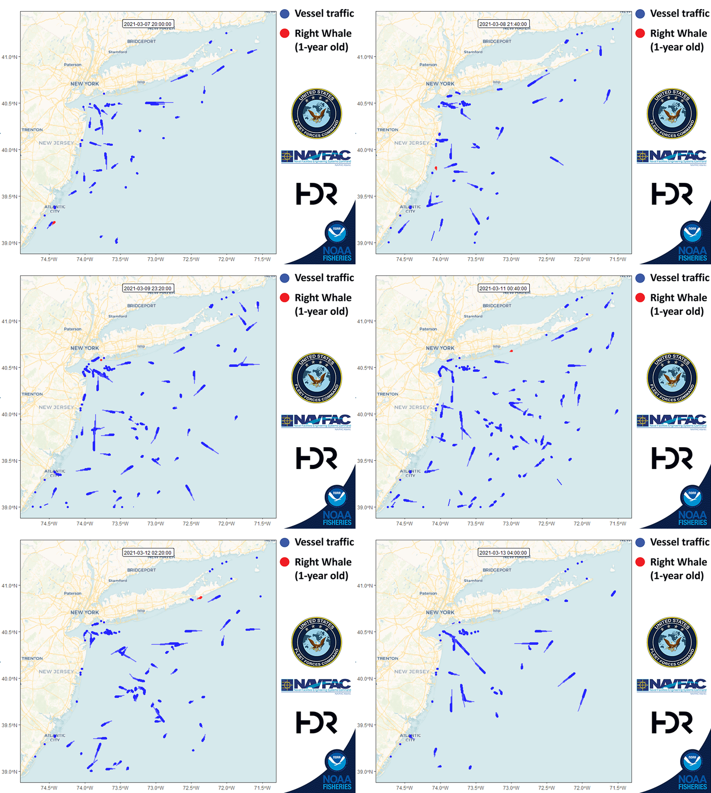
In addition, all westbound and eastbound commercial traffic entering major East Coast ports crisscrosses the whales’ corridor. Within calving waters alone, the ports of Jacksonville, FL, Savannah, GA, and Charleston, SC, receive 8,000 to 10,000 65 ft-plus in-and-out vessel transits per year.
Because of extensive aerial surveillance, researchers have cataloged most existing right whales. Each animal is assigned a four-digit number, and many are eventually named for a unique physical feature. The collaborative data-sharing group, the North Atlantic Right Whale Consortium maintains a list of identified right whales. Researchers familiar with the species can identify a whale the moment it surfaces by the fingerprint-like callosity patterns on its head.
Many known reproductive females returned to the calving grounds this year. Researchers joyfully recognized Mirror (#4617) by her symmetrical callosity patterns, Ghost (#1515) resembling a cartoon ghost with two dark circles for eyes, and Mantis (#1620), Boomerang (#2503), and Cascade (#3157) by their namesake patterns.
Meyer-Gutbrod’s research is geared towards protecting the mothers and their offspring—critical to the species’ survival. “The question was, can we even use these tools—underwater gliders—to improve conservation in the calving grounds?” noted Meyer-Gutbrod.
“I would say at this point, we’ve answered it: Yes. We can use that tool. And that’s been really exciting!”
Innovative Passive Acoustic Technologies and Right Whale Slow Zones
Dr. Edwards founded and leads the regional autonomous glider observatory at Skidaway Institute, located southeast of Savannah, GA. It sits off the South Atlantic Bight, characterized by shallow shelf waters, extreme tidal currents, and the fierce boundary flow of the Gulf Stream. Deploying AUVs in this area requires exacting, minute technical adjustments and mean piloting skills.
Edwards’ background is in the physics of coastal oceans, but through the use of the AUVs, she’s become adept at solving engineering conundrums. “A lot of my work is kind of egg-heady,” says Edwards, describing her work with gliders for over two decades across diverse and crucial applications. Edwards and her group have deployed gliders into the paths of approaching hurricanes to measure ocean heat content and salinity in real time, to feed forecasting models. Following the Deepwater Horizon disaster, Edwards also deployed gliders to map oil dispersion and oxygen levels in the then Gulf of Mexico.
Coincidentally, Skidaway is also in the heart of the right whale’s preferred birthing waters.
“It was an almost supernatural collaboration,” says Edwards. “Here’s the whales expert [Meyer-Gutbrod], and who knows better how to fly gliders in this area than our group.”
Dr. Meyer-Gutbrod’s lab was already collaborating with Woods Hole Oceanographic Institution (WHOI), in the use of hydrophones to detect the right whale’s distinctive “up-calls”. “Those instruments sat at the bottom for 6 months collecting information before someone would pick them up at the end of the season and discover whether or not right whales were making calls,” noted Meyer-Gutbrod. “More important, from a conservation standpoint, are the assets that have real-time capabilities.”
NOAA’s regulatory efforts to protect areas along right whales’ migration routes include management models to slow maritime traffic, such as Seasonal Management Areas (SMAs), Voluntary Dynamic Management Areas (DMAs), and Acoustic “Right Whale Slow Zones.” Other protective policy frameworks include Critical Habitat Designations, Approach Rules, and the Atlantic Large Whale Take Reduction Plan (ALWTRP).
SMAs and DMAs came into effect in 2008. 10 distinct SMAs along the East Coast require 65-plus-foot vessels to adhere to a mandatory 10-knot speed during different seasons. For example, the Great South Channel SMA protects the right whale’s feeding grounds, setting static boundaries with a northern limit east of Cape Cod in the Gulf of Maine from April 1 to July 31. Southeast of Cape Cod and east of Nantucket, intense localized upwelling brings dense agglomerations of C. finmarchicus to this SMA.
The DMAs are more “dynamic” and temporary, with flexible 15-day zones activated in real time only when visual aerial surveys or vessel reports observe three or more right whales outside an SMA. Mariners are asked to reroute or slow down to 10 knots or less voluntarily.
In the Southeast, the Calving & Nursery Grounds SMA, from Brunswick, GA to St. Augustine, FL, is active November 15 to April 15, protecting the mothers that migrate to warmer waters to give birth.
After the catastrophic 2017 UME set the right whale’s population recovery back years, and based on decades of studies by marine researchers such as Meyer-Gutbrod and technological advances by institutions like WHOI, NOAA’s Greater Atlantic Regional Fisheries Office implemented Acoustic “Right Whale Slow Zones” in 2020. These are temporary 15-day voluntary slow zones triggered exclusively by acoustic detections from hydrophone buoys, autonomous underwater vehicles, or gliders that identify whale upcalls.
This monumental breakthrough in real-time passive acoustic monitoring was driven by the pioneering work of WHOI Chief Scientist Dr. Mark Baumgartner, who developed the Low-Frequency Detection and Classification System (LFDCS), which can detect right whale up-calls and transmit compressed audio data via satellite in real time.
Meyer-Gutbrod and Edwards began testing Baumgartner’s system on a Teledyne Slocum Glider in early 2023. Initial deployments south of Savannah, GA, intercepted northbound whales in the spring, and deployments north of Charleston, SC, intercepted southbound whales in the autumn—marking the first formal expansion of real-time glider acoustic monitoring into the calving grounds.
Autonomous Underwater Gliders Identify Whale Up-Calls
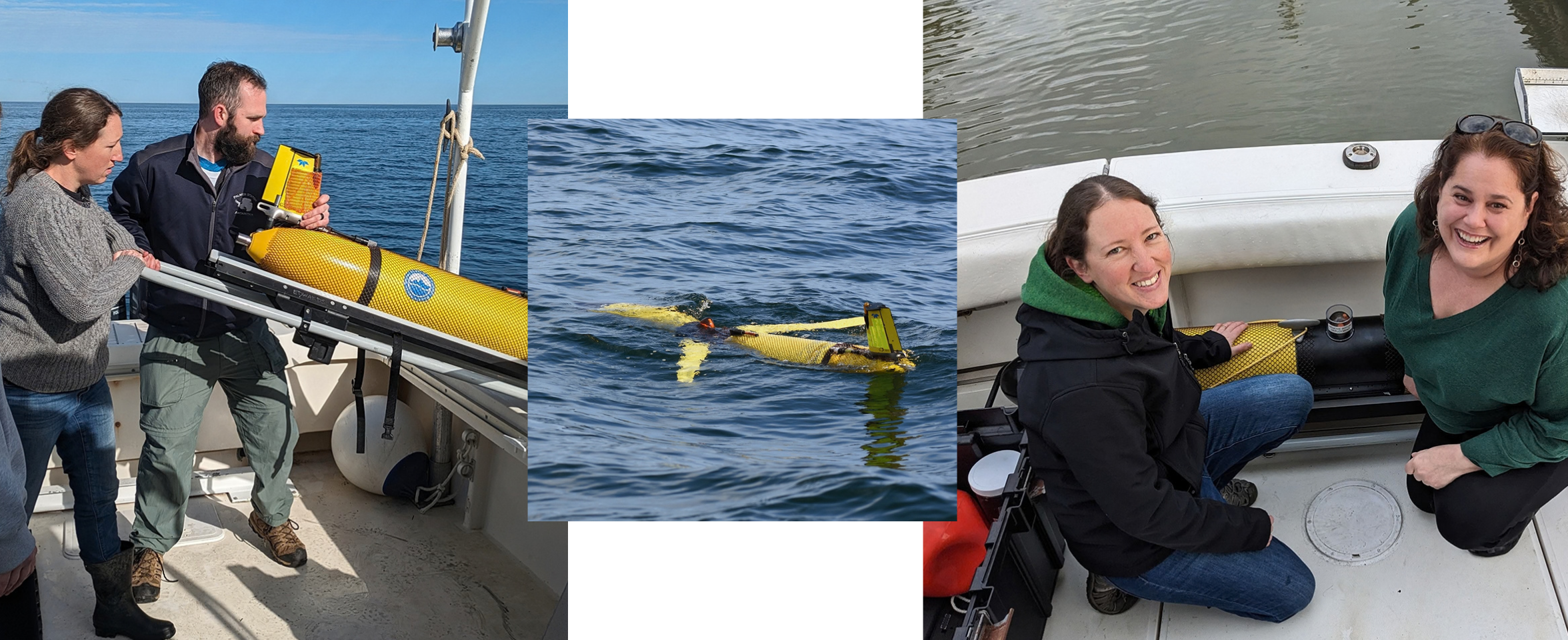
Two SECOORA gliders are funded for the next two years with two 30-day missions per glider per year (a total of between 100-120 days of calving grounds monitoring).
The gliders are energy efficient and quiet, and they are impervious to bad weather and darkness. “I think the best tool in our toolbox are the gliders,” says Meyer-Gutbrod. “We can tell it where to go, and aim it toward places that need surveillance or places where aerial surveys have reported right whales.”
Each glider deployment seeks not only to find the whales through their calls, but also to fine-tune their locations over time.
“One of my big questions is a fundamental one,” says Edwards, “Like how close to a whale do you need to be to hear it?”
At the heart of the Slocum glider is the PAM-processing hardware, the Digital Acoustic Monitoring instrument (DMON), developed by WHOI, and Baumgartner’s LFDCS software.
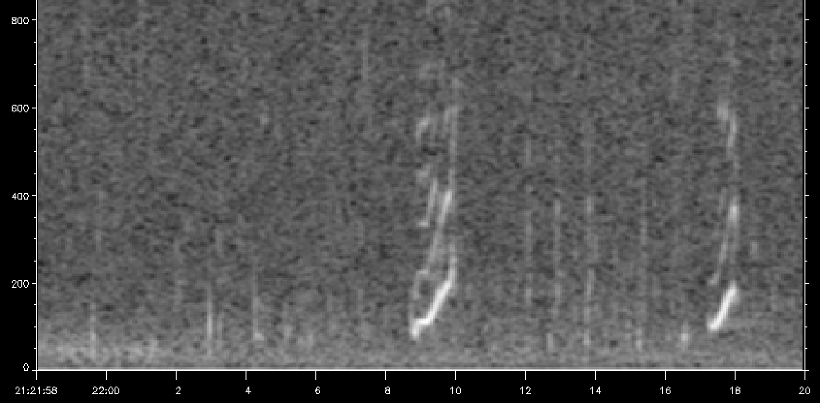
The DMON hydrophone records ambient acoustic signals while the LFDCS software processes the audio, filtering out background noise from ship engines, waves, and rain. The software converts raw audio into a spectrogram (a visual representation of sound frequencies over time), isolates low-frequency sounds, and extracts simplified digital contours called “pitch tracks”.
“As the hydrophone is listening, it is actively comparing the signal it gets to this library of calls so it can automatically make a detection,” says Edwards.
When an underwater glider surfaces, if there’s a match between what it’s heard and what’s in its library, it will send the compressed telemetry via Iridium satellite to servers onshore.
Bioacoustic analysts at WHOI or NOAA review the pitch tracks and verify the right whale’s call. Once confirmed, the detection feeds platforms like WhaleAlert and Whalemap and directly triggers NOAA’s 15-day voluntary Acoustic Right Whale Slow Zone.
WhaleAlert is a free mobile app that provides vessels, mariners, and fishermen a near-real-time display of active restriction zones, dynamic management areas, and verified whale detections (both acoustic and visual sightings) along the U.S. East and West coasts. Whalemap is an open-source web application that synthesizes and visualizes multi-agency right whale monitoring efforts into a single interactive map.
Turning her expertise to whale surveillance imbued Edwards with a new sense of wonder. Whereas her contributions focus on operational physics, including calculating how deep gliders can dive near port approaches (like Savannah and Charleston) without dragging across the seafloor, or minimizing the gliders’ own mechanical noise, she is amazed by people’s emotional response to her right whale monitoring work.
“Never before had anybody started crying because of my work on coastal ocean physics,” she says.
One concern was whether the gliders could improve conservation efforts in the calving grounds, where sound propagates differently in shallow waters and where the whale moms are quieter, possibly to avoid drawing attention to their calves.
“Gliders don’t have propellers—there is no active propulsion,” explains Edwards. “They move by changing their buoyancy and center of gravity.” This turns gliders into stealth monitoring platforms that can fly closer to an animal without causing it additional stress.
She describes how wings attached to the glider hull convert vertical sinking and floating into forward movement. As the vehicle grows denser, gravity pulls it toward the seafloor, and when an internal pump changes its displacement, it becomes buoyant and flies upward toward the surface.
“And all you’ve done is move these two little motors,” says Edwards.
“It was so amazing to hear a right whale below Norfolk, VA, for the first time,” says Meyer-Gutbrod. “We told NOAA, and then NOAA sent out an alert and asked vessels to slow down.”
For scientists and conservationists, the struggle is implementing mandatory protective measures immediately, not years down the road. The 2025-2026 calving season’s 23 new calves—the highest number since 2009, and a 29 percent increase compared to the previous season—offer tangible proof that recovery is possible, and that science-driven collaborations can safeguard future generations of this sentinel species.
Related news
Saving the North Atlantic Right Whale: Underwater Gliders Join the Fight to Save a Species
Meet the SECOORA-funded scientists using underwater gliders and acoustic tech to protect critically endangered North Atlantic right whales.

Dave Wells Joins SECOORA as Ocean Observing Systems Team Lead
SECOORA welcomes Dave Wells as Ocean Observing Systems Team Lead where he will oversee SECOORA's coastal observing system assets and data management.
At the Water’s Edge: Lowcountry Coastlines in a Brave New World
A nor'easter's record storm tide. A stalled tropical storm. Two Lowcountry towns adapting to a new era of flooding, with SECOORA data in hand.