The Southeast Coastal Ocean Observing Regional Association (SECOORA) Data Challenge invites undergraduate students, graduate students, and early career professionals to develop a project that incorporates and analyzes buoy and/or shore station data using archived SECOORA data. There are two $3,500 prizes. Proposals are due Friday March 12, 2021 at 5:00 PM ET and should be submitted through egrants.secoora.org.
Click here for a PDF of the 2021 Data Challenge Request for Proposals.
Overview
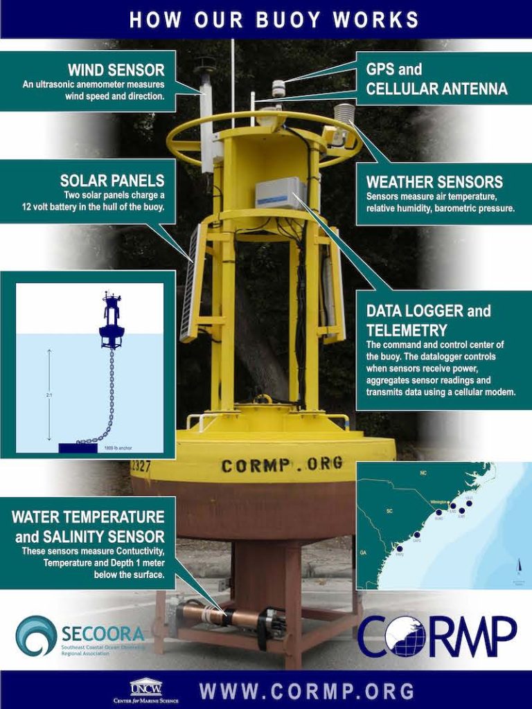
Moorings, often called buoys, are attached to a floating surface structure that is anchored (i.e., moored) to the ocean floor. Buoys can include a number of technologies that might be for a single purpose such as measuring wave heights or include a variety of sensors mounted both above and below the water surface to measure different variables. Most buoys relay data back to shore in real-time. Profiling buoys include sensor packages that regularly move up and down the mooring line and provide a comprehensive view of the water column. Buoys can be outfitted with sensors for measuring wind, waves, currents, salinity, chlorophyll a, and other physical, chemical, or biological parameters. See the image to the right for an example of a buoy with its science sensors and communications equipment.
Shore stations are installed on coastal beaches, islands, and piers where they are more easily accessible than ocean-based buoys. Shore stations can measure a range of parameters including wind speed, gust and direction, air temperature, relative humidity, barometric pressure, solar radiation, rainfall, water level, water temperature, water quality data, and more. These basic measurements provide important real-time, near shore information that helps track storm impacts and monitors water levels and local water quality. When measurements are collected over a long-time period, they can also help predict climate change impacts.
The SECOORA is one of the 11 Integrated Ocean Observing System (IOOS®) regional partners. IOOS supports buoy and shore station operations in all US coastal regions. SECOORA supports 13 buoys off of North Carolina, South Carolina, and Florida and 6 shore stations in South Carolina and Florida. These stations augment the federal and state deployed stations throughout the region.
About the Dataset
SECOORA supports 13 buoys off of North Carolina, South Carolina, and Florida and 6 shore stations in South Carolina and Florida. The buoys collect a range of atmospheric and water quality data for nearshore environments. A full list of active SECOORA buoys and shore stations, along with the parameters they collect, is found in the table below. This webpage provides the data available for each active and historic SECOORA funded station and their parameters.
| | Wind Spd, Gust, Dir. | Air Temp | Baro. Pressure | Rel. Humidity | SW / LW Radiation | Water Temp | Currents | Waves | Cond/ Salinity | Water Level | Fish Acoustic Sensors | Chlorphyll, Dissolved Oxygen, Turbidty, pH, Water level |
| Active UNCW Moorings: | ||||||||||||
| LEJ3 – Outer Onslow Bay | X | X | X | X | | X | | | X | | X | |
| LEJ3Wave | | | | X | | X | | | | |||
| ILM3 – Outer Onslow Bay | X | X | X | X | | X | | | X | | X | |
| ILM2 – Inshore Onslow Bay | X | X | X | X | | X | | | X | | X | |
| ILM2Wave | | | | X | | X | | | | |||
| SUN2 – Northern Long Bay | X | X | X | X | | X | | | X | | X | |
| SUN2Wave | | | | | | X | | | | |||
| CAP2 – Inshore Capers Island | X | X | X | X | | X | | | X | | | |
| FRP2 – Inshore Fripp Island | X | X | X | X | | X | | | X | | | |
| OB27 – Onslow Bay (non-real time under Data Tab) | X | X | X | X | | X | ||||||
| Active USF Moorings | | | | | | | | | | | | |
| C10 – WFS Central nearshore | X | X | X | | X | X | | | | | | |
| C12 – WFS Central offshore | X | X | X | | X | X | | | | | | |
| C13 – WFS South | X | X | X | | X | X | | | | | | |
| C21 – Tower | X | X | X | X | | X | X | X | | | | |
| Active USF Shore Stations | | | | | | | | | | | | |
| Shell Point | X | X | X | | | | | | | X | | |
| Aripeka | X | X | X | | | | | | | X | | |
| Fred Howard State Park | X | X | X | | | | | | | X | | |
| Clam Bayou | X | X | X | | | X | | | X | X | | X (data) |
| Big Carlos Pass | X | X | X | | | | | | | X | X | |
| Active SCDNR Shore Station | | | | | | | | | | | | |
| Fort Johnson | X | X | X |
Data from these stations are used to:
- improve marine weather forecasts and models
- increase accuracy for storm track and storm surge inundation
- support scientific research
- issue marine warnings
Data challenge contestants are required to use at least one of the SECOORA buoy or shore station datasets in their project. Other datasets (such as National Data Buoy Center (NDBC) and Coastal Data Information Program (CDIP) buoys, National Estuary Research Reserve System (NERRS) data, Center for Operational Oceanographic Products and Services (CO-OPS) water level stations, High Frequency Radar, and glider data) can also be used in the project. All of the data are available on the SECOORA Data Portal and in the SECOORA Data Catalog.
Ideas
There are many uses of buoy and shore station data. Below are some example project ideas to get you started. You do not have to propose something on this list; these are just examples:
- Develop climatology visualizations for water level, waves, or other data sets
- Analyze multi-year hurricane data based on observations near the storm path
- Conduct a multi-year water quality data analysis and provide information on trends
- Create lesson plans for students using mooring and shore station data
- Characterize the available Marine Hydrokinetic Energy from mooring data
Prizes and Eligibility
SECOORA is offering two prizes in two different categories. Applicants can work as an individual or in teams. If working as a team, all members must meet the eligibility requirements.
Category 1: Undergraduate
Prize: $3,500
Eligibility
Applicants must 1) reside in and attend an academic institution in the United States, 2) be an undergraduate student, 3) have an advisor/mentor from the institution they attend, 4) be enrolled as an undergraduate student during the Spring 2021 semester, and 5) propose a project that incorporates at least one dataset from the buoys and/or coastal stations funded by SECOORA (see table above): http://stage-secoora-maps.srv.axds.co/stations/
Category 2: Other
Prize: $3,500
Eligibility
Applicants must 1) reside in the United States, 2) be a graduate student OR an early career professional (working less than five years from your most recent graduation date), 3) have an advisor/mentor, and 4) propose a project that incorporates at least one dataset from the buoys and/or coastal stations funded by SECOORA (see table above: http://stage-secoora-maps.srv.axds.co/stations/
SECOORA is committed to building inclusive research, extension, communication, and education programs that serve people with unique backgrounds, circumstances, needs, perspectives, and ways of thinking. We encourage applicants from all backgrounds to apply for this competitive opportunity.
Proposal Format
All proposals must follow the required format below. Proposals that do not follow the required format will not be evaluated.
Maximum page length is five pages (does not include appendices). Text should be 12-point font, margins 1-inch and must include the following components:
- Title Page (Proposal Cover Sheet) is limited to one page and must include:
- Proposal title
- Category under which you are applying: Category 1: Undergraduate or Category 2: Other
- Lead applicant’s name and complete contact information
- Team members, if any, and complete contact information
- Advisor name and contact information (i.e. professor supervising work)
- Project summary (one paragraph)
- Project Description is limited to four pages and must include:
- Statement of the issue to be addressed
- Description of the product or tool that will be developed
- Statement of how the project will directly benefit specific users or stakeholders (please list all partners if there are any)
- Goals, objectives and anticipated results
- Methodology or approach, including:
- Explanation of the technical approach
- Data analysis and/or visualization techniques that will be employed
- Describe project deliverables and how results will be shared with users/stakeholders. Upon completion of the project, you will need to:
- Provide a brief report on how the data was used for the project.
- Produce a short video on the project, and its value to you and potential users.
- Products, algorithms, curriculum, etc. should allow for unrestricted distribution or integration on the SECOORA website.
The following appendices are required; however, they do not count towards the page limit.
- Appendix 1: Project timeline that lists the project objectives and when you plan to complete each objective and submit your final results to SECOORA (note the project must be completed by January 31, 2021). (1-page maximum)
- Appendix 2: For undergraduate and graduate students, a signed letter of support from their major professor is required stating you are a student in good standing.
- Appendix 3: One or two-page resume or curriculum vitae (CV). If working in a team, please provide a one-page resume or CV of all team members.
Proposal Submission
Please submit the entire application package electronically in PDF format through egrants.secoora.org. The submission deadline is 5:00 PM ET on March 12, 2021. You must complete the registration process in order to upload a proposal to egrants.secoora.org. This is a two-part verification system (phone and email confirmations are required). Once you have registered, please select the Request for Proposals to which you are applying, complete the required fields, and upload your proposal as a complete PDF. Proposals can only be submitted in one category.
Evaluation Criteria
All proposals will be evaluated based on the following criteria:
- Creativity and Innovation – 25%
- Demonstrated Value to a Stakeholder – 25%
- Technology/Scientific Merit – 20%
- Methodology – 20%
- Follows Proposal Guidelines – 10%
Projects that produce multiple deliverables will be ranked higher.
Timeline
March 12, 2021: All proposals are due via egrants.secoora.org at 5:00 PM ET.
March – April 2021: Proposal review period. Applicants may be contacted and asked to discuss their project with judges on a webinar.
April 2021: Winners are notified.
January 31, 2022: Full projects are completed. Final product deliverables are submitted to SECOORA and include the product/application and all appropriate documentation. The use of open-source software is encouraged, and all final products should allow for unrestricted distribution on the SECOORA website.
Questions
Questions regarding proposal submission may be submitted to abbey@secooraorgpact.wpengine.com. Good-faith efforts will be made to answer as many questions as possible, but an answer is not guaranteed for every question.
Award Distribution Information
Winners will receive half of the award ($1,750) by May 2021. Upon completion of the project, winners will need to provide a brief report and video on the project and the value/impact of the work. Once deliverables are approved, winners will receive the remaining portion ($1,750) of the award. Award winners will be responsible for all tax liabilities associated with the winnings and a 1099 will be disbursed by SECOORA by February 1, 2022.
This is an open and competitive process. SECOORA reserves the right to reject any and all applications/proposals received as a result of this process. SECOORA reserves the right to request that applicants make modifications to proposals at any time before an award is made.
Related news

Abbey Wakely Joins SECOORA as Director of Communications and External Affairs
SECOORA welcomes Abbey Wakely as their new Director of Communications and External Affairs, where she will lead strategic engagement, communications, and external relations to strengthen the organization’s regional impact.

SECOORA Request for Proposals for a Data System Development, Operations, and Maintenance Service Provider
SECOORA seeks a Data System Development, Operations, and Maintenance (DMAC) service provider to act as a strategic partner while maintaining the current SECOORA Data System. Proposals are due to SECOORA by 5:00 PM ET, March 31, 2026.

Plankton Perfect: Using Imagery to Document Microscopic Marine Life
Dr. Enrique Montes is working to understand how plankton respond to changes in the ocean by capturing high resolution imagery with advanced technology. This work is funded by the Marine Biodiversity Observation Network (MBON) to use novel techniques like the Continuous Particle Imaging and Classification System (CPICS).

