

Reimagining the Deep: BioTrack’s Quest to Map Marine Biodiversity Hotspots
By Zoraida Díaz
On June 8th, we celebrated UN World Oceans Day under the theme “REIMAGINE: Beyond the World We Know, A New Relationship with our Ocean.”
BioTrack, a multi-year collaborative initiative that aims to identify, monitor, and predict marine biodiversity hotspots through satellite and acoustic animal tracking, is doing just that.
Supported by the US Marine Biodiversity Observation Network (MBON) and the Animal Telemetry Network (ATN), BioTrack leverages established academic and government partnerships to map how and where marine species interact. By connecting networks along the Atlantic Coast—from Maine to the Florida Keys and into the Gulf of America and the Caribbean—the initiative aims to share data, exchange insights, and fill critical blind spots in our understanding of behavioral ecology.
The project invites researchers to contribute animal-tracking data from across the marine ecosystem—from river herring to terns, leatherback turtles, crocodiles, bull sharks, and blue whales. These shared data will help identify critical migration pathways and multi-species hotspots (geographical areas with high concentrations of diverse species), as well as enhance our ability to predict and manage where threatened marine wildlife intersects with expanding human ocean-use.
Dr. Neil Hammerschlag, the Executive Director of the Shark Research Foundation and lead researcher of BioTrack, explains: “Where does each species spend the most time? Where are their hotspots? And where do they overlap?”
“Imagine a Venn diagram,” says Dr. Hammerschlag, “You have three circles representing individual hotspots for eagle rays, hammerheads, and sea turtles. But where do they all intersect?”
“The goal ultimately is to evaluate how ocean warming, and other impacts and changes to the environment, alter the overlap of these key biodiversity hotspots, especially within regions that are either marine protected areas or highly vulnerable to exploitation.”
The stakeholder-driven project aims to deliver data and information products to end users. “This project is unique because, from the onset, we asked wildlife managers, including Florida Fish and Wildlife, National Marine Sanctuary directors and staff, policy makers, biologists, and others what specific data on multi-species hotspots and human overlap they actually needed,” adds Dr. Hammerschlag, “And exactly how they wanted that data formatted.”
What the Ocean has to Say
BioTrack “listens” to the ocean through a network of over 3,500 underwater acoustic receivers—devices that detect tagged marine animals. The receivers log any tagged fish when it swims near the receiver. Tag data recorded by the receiver is downloaded every 4-6 months. One of the Animal Telemetry Networks along the US Atlantic coast is the Florida Atlantic Coast Telemetry (FACT) Network. FACT alone includes partners from the Bahamas to the Carolinas and has more than 2,600 acoustic receiver stations.

BioTrack also “watches” the ocean from space through satellite tracking. These tags rely on the Argos satellite system, which tracks animals via polar-orbiting satellites. The use of acoustic or satellite tags depends on how often the animal surfaces and whether the species migrates long distances. Satellite tags, whether SPOT tags (Smart Position and Temperature) or PSATs (Pop-up Satellite Archival Tags), require a clean line of sight to the sky to transmit data, as radio signals cannot travel effectively through water. Whales, sharks, sea turtles, birds, and large surface-swimming fish such as sailfish, Atlantic marlin, and ocean sunfish are ideal candidates for satellite tracking.
The BioTrack initiative then combines acoustic and satellite telemetry data with satellite-derived environmental data to map biodiversity hotspots. Satellite sensors track environmental Essential Ocean Variables (EOVs)—key indicators of ocean health—including Sea Surface Temperature (SST), Chlorophyll-a Concentrations (Ocean Color, which indicates phytoplankton levels), Sea Surface Height (Altimetry), and Salinity. For instance, when the movements of tagged whales, sharks, sea turtles, and other animals are plotted over months, satellite indicators from those exact dates can be superimposed onto the track lines. Instantly, the maps reveal where different species slowed down and congregated during oceanographic events like a cold, nutrient-rich upwelling. By merging these datasets, the BioTrack team can predict where multi-species hotspots will form as ocean conditions change.
Woody Turner, Program Scientist for Biological Diversity and Assistant Program Manager for Ecological Conservation at NASA, calls BioTrack “a powerful biodiversity observation initiative.”
“BioTrack dynamically tracks changes in location over time,” says Turner. “This dynamism allows for increased understanding of animal behavior.”
NASA’s own Internet of Animals (IoA) project is designed to integrate NASA satellite data with animal telemetry (the process of collecting and transmitting data on animals’ movements and behaviors using remote devices) for all animals, while also improving technologies for conducting animal tracking from space.
Turner says IoA and BioTrack are mutually supporting activities because NASA is working on both reducing the size of animal tags and developing satellite-deployable receivers so that other satellites can capture signals from tagged animals with satellite transmitters.
“Integration of information across satellites is a needed technology not only for animal telemetry, but for most Earth system science work,” Turner says. “The challenge of multi-modality—bringing together data from multiple satellite sensors as well as integrating data between satellite and in situ sensors—is key to future monitoring of the Earth system.” Common examples of in situ, or on-site, devices include weather stations, ocean buoys and floats, and acoustic receiver stations, such as those of the FACT Network.
Tagging Pelagic Sea-Dwellers

The BioTrack project already includes historical and newly generated data from more than 3,000 tagged animals, representing over 60 species across the Northwest Atlantic and the Gulf.
“BioTrack is looking to see which marine animals are in our inventory, where the gaps are, what species are missing, what areas are missing,” said Dr. Hammerschlag. “For instance, in the thousands of tags that BioTrack has access to, we didn’t have a blue whale!”
Based on that assessment, BioTrack is providing 208 acoustic and satellite tags to researchers working with underrepresented species for deployment this year. Of those, over 30 tags have been deployed on species including blue whales, whitespotted eagle rays, loggerhead turtles, Atlantic cod, and the ocean sunfish (Mola mola).
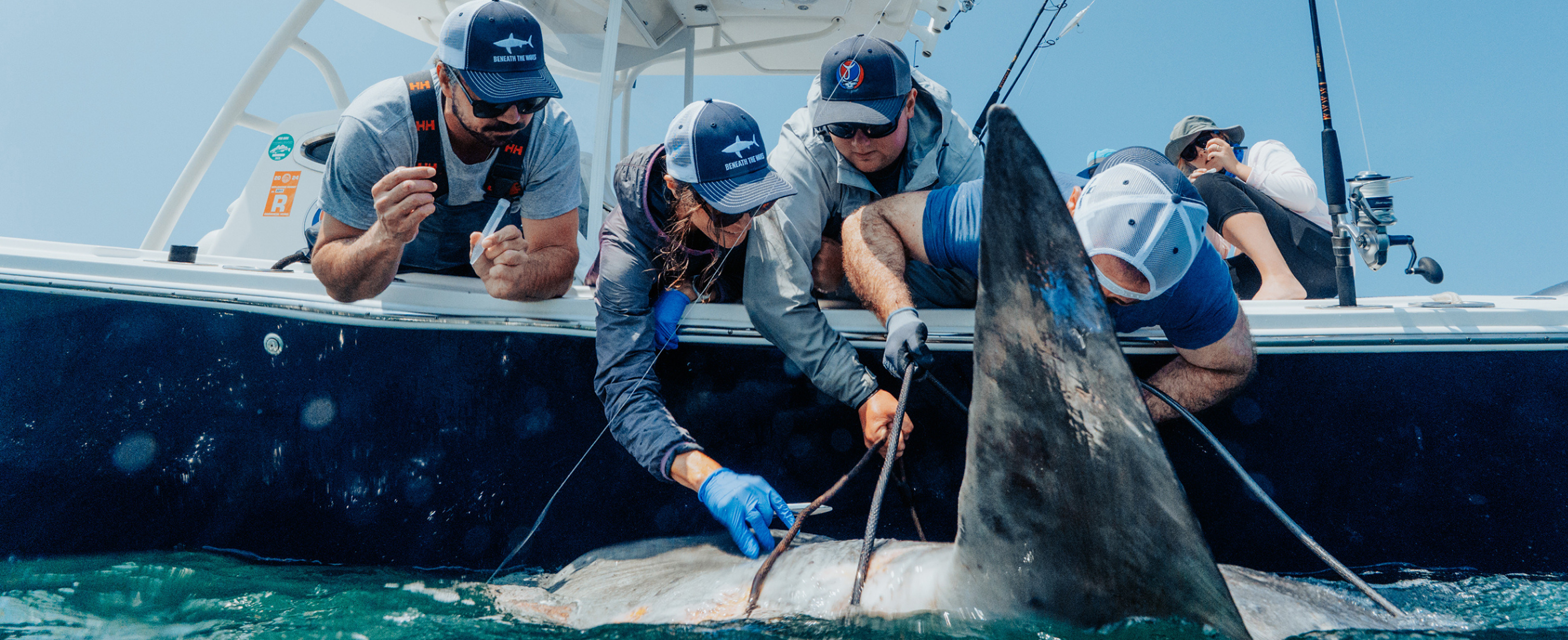
Dr. Hammerschlag is a pioneer in non-invasive shark tagging; traditionally, sharks are hooked and restrained alongside vessels, and satellite tags fitted on their dorsal fins. To avoid the stress of capture, he adapted a remote tagging system originally designed for whales and dolphins: titanium darts fired from a veterinary-grade CO₂-powered rifle attach the SPOT tag to the shark’s dorsal fin. His first success was tagging a 14-foot free-swimming great white shark named “Salvager” off the southwest tip of Nova Scotia last year.
His excitement is palpable when the talk turns to tags, and he pulls up a satellite-tracking map on the computer screen to share the trajectory of a Mola mola tagged by the nonprofit marine research organization Beneath the Waves.
Dr. Brendan Shea, Associate Director of Science Programs at Beneath the Waves explained the reach of the Mola mola study in a recent webinar: “We’re also taking genomic approaches, looking at the microbial organisms living on the skin of the Mola mola to start making some inferences about how these ocean giants really serve as vectors of connectivity, making our ocean a little more resilient to disturbance.”
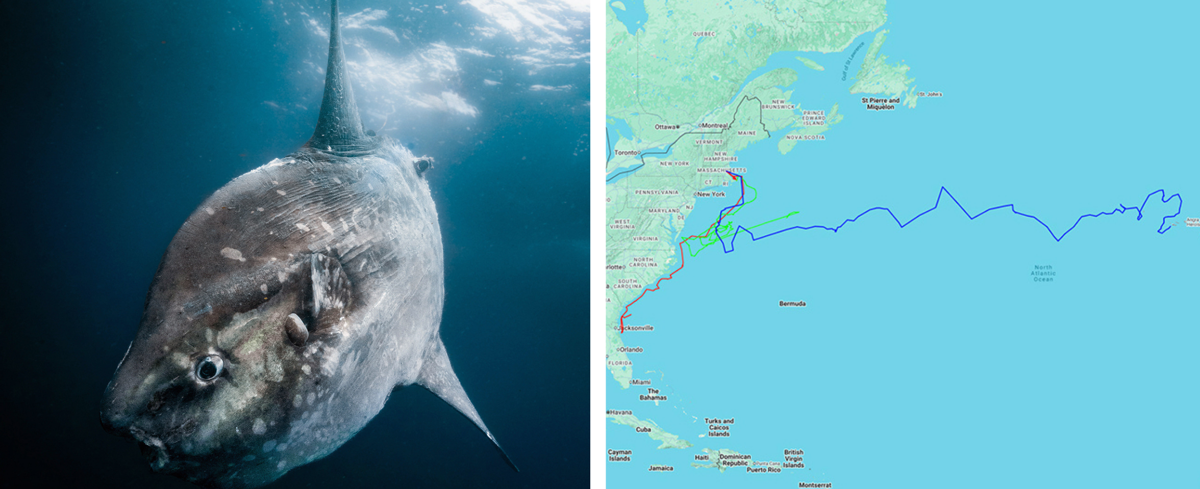
A Mola mola can measure 10 feet across from fin to fin and can weigh over 1,000 lbs (454 kg). It sunbathes for hours on the surface of the ocean, but can dive down to 2,500 feet (762 meters) to hunt. “It looks like a cratered moon with fins. It’s floppy-looking and has an alienish eye that swivels as it looks at you,” says Dr. Hammerschlag, “It doesn’t look at all hydrodynamic like a dolphin or a shark.”
And yet, the Mola mola on the map, PPT decimal tag no. 40199—or Mola Superstar, as Dr. Hammerschlag calls it—was tagged in the New England/Mid-Atlantic shelf waters on September 18, 2025. The PPT (Platform Terminal Transmitter) is a unique electronic ID tag that transmits radio signals up to passing satellites to determine the animal’s location and relay sensor data. By May 31, 2026, this fish had traveled in zig-zag and up and down the water column, some 4,163 miles (6,700 kms) to within 12.4 miles (20 kms) from Horta, a port city on Faial Island in the Azores.
The Mola mola’s astounding feat spearheads BioTrack’s mission to study biodiversity hotspots and confirms migration along transatlantic ocean currents while gathering incisive data about open-ocean ecosystems, jellyfish populations (which are the Mola’s favorite food), and changing sea surface temperatures.
“Let’s network the networks,” says Dr. Hammerschlag, “let’s see where everyone’s animals went, everywhere, all together, all at once.”
It is with the same excitement that researchers of diverse species are tagging animals, contributing data to MBON, and reimagining new collaborative efforts to combat the rapid decimation of our Oceans.
Atlantic cod (Gadus morhua) and the western Gulf of Maine

Recent BioTrack taggings include Atlantic cod in both coastal New Hampshire near the Isles of Shoals and in an area known as “West Cod Ledge” in Casco Bay, Maine. Both sites have underwater rocky ledges and a hard-bottom seafloor, creating ideal cold-water habitats for kelp forests and groundfish such as haddock, pollock, mackerel, and Atlantic cod.
Acoustic receiver arrays in both strategic areas detect sharks, seals, whales, and fish as they travel seasonally up and down the Gulf.
Led by Nathan Furey, Associate Professor at the University of New Hampshire and head of the Fish and Movement Ecology Lab, the project focuses on Movement Ecology, which treats movement as a fundamental biological process driving evolution, biodiversity, and ecosystem health. It uses several methods to monitor life in the area, including collecting eDNA, using sound to detect animals (acoustics), and tracking individual animals (telemetry). The research aims to show how warmer water affects cod’s survival, what they eat, and when and where they travel in the Gulf of Maine. The project receives support from both the BioTrack project and the Coastal New England group within the Marine Biodiversity Network (MBON).
The use of BioTrack acoustic tags is extending the reach of Atlantic cod movement studies in coastal New England. “These tags give us another year of insight into the movements of these fish,” said Dr. Furey, “and it’s exciting to know that while we learn more about cod, our efforts will also help to quantify the multi-species use of the Atlantic coastline.”
The surgically implanted tag emits signals, or “pings,” for as long as the tag’s battery lasts, which ranges from one to five years. These pings are picked up by receivers along the coast and integrated into a larger detection database. Over time, each individual cod’s movement patterns can be determined based on when the fish swam by a specific receiver. These tag detections help build an understanding of the species’ preferred seasonal habitats. On average, Dr. Furey’s tagged cod are 15.7 in long (400 mm) and just under 2.2 lbs (1 kg). But the range is from 7.9 in (200 mm) to 23.6 in (600 mm).
A Troubled History

The Atlantic cod fishery is tightly regulated to rebuild stocks after the collapse of the Northwest Atlantic groundfish in the first decade of the 21st century.
Fishermen’s logbooks from the late 1800s show Georges Bank annual catches of 80,000 metric tons using handlines. Cod once lived for 20-30 years, grew to 6 feet (1.8m) long, and weighed up to 200 pounds (91 kg). Now, even a 40-pound fish is rare, and a 15-pound catch is cause for celebration.
Over the last two decades, the bountiful cod population has not recovered, and annual landings have dropped well below 500 metric tons. Emergency conservation restrictions reduced the annual catch limit for Georges Bank cod to 194 metric tons, while total cross-stock limits for the wider New England area were set at 382.9 metric tons.
“Why western Gulf of Maine cod haven’t recovered even with reduced fishing effort is complex, with many interacting and competing hypotheses like warming waters, predation, and changes in food availability,” says Dr. Furey, “I certainly wouldn’t pretend to have the answers, and nor will our project provide the ‘silver bullet.’”
One reason cod now stay small, grow slowly, and lay fewer eggs may be a change in diet. Traditionally, juvenile cod ate high-energy forage fish like herring, which is no longer as available. Instead, cod have turned to other, less calorie-rich options like cunner and crabs. “We are interested in the impacts of cod eating crustaceans versus fish on its potential growth via bioenergetics models,” explains Dr. Furey. Bioenergetic models function as environmental calorie trackers that map how changes in water temperature, prey availability, and pollution impact an animal’s daily energy balance.
“Because Atlantic cod generally move little when not migrating, their diet samples local biodiversity, allowing us to compare the fish and invertebrate communities between our NH and ME study sites,” says Dr. Furey.
The data collected can reveal when fish move between management areas and help managers understand cod connectivity among protected zones during times when fishing is banned. By mapping these movements, Dr. Furey and his team can determine whether protected areas align with fish migration patterns and identify the exact locations and weeks when fish face the highest risk from targeted fishing or accidental bycatch.
Kemp’s ridley sea turtle (Lepidochelys kempii ) in Crystal River, Florida

Of the seven species of sea turtles swimming the world’s oceans, the Kemp’s ridley is the rarest and most endangered.
Dr. Mariana Fuentes, head of the Marine Turtle Research, Ecology, and Conservation Group at Florida State University, is using biologging packages and acoustic telemetry data to expand the scope of her research on the spatial ecology of juvenile Kemp’s ridley sea turtles, with access to MBON’s broader datasets and interdisciplinary collaborations.
As with all marine organisms, understanding how species move through time and space is key to determining conservation strategies. Although 95% of worldwide Kemp’s ridley births occur on three beaches in Tamaulipas, Mexico, the juvenile Kemp’s ridleys are highly migratory. They use the Gulf Stream to travel up the eastern seaboard and feast on crabs, as far north as Cape Cod and the Gulf of Maine.
“This partnership with MBON and BioTrack has strengthened both the scale and impact of our work,” said Dr. Fuentes, “and has allowed me to contribute to cross-taxa research initiatives, integrating sea turtle ecology within larger marine biodiversity and ecosystem studies to better understand species interactions and responses to anthropogenic stressors like commercial fishing, shipping lanes, pollution, warming waters, or habitat degradation.”
Seven Wonders of the Sea

Dr. Fuentes’s research encompasses the seven species of sea turtles, including targeted fieldwork on Kemp’s ridleys (Lepidochelys kempii), loggerheads (Caretta caretta), and green sea turtles (Chelonia mydas) along the US Atlantic and Gulf coasts. Her work aligns perfectly with BioTrack’s mission to identify, monitor, and predict sea turtles’ changing biodiversity hotspots and migration corridors. Mapping how these vital areas intersect with human activities is crucial to designing dynamic marine protected areas to keep sea turtles from disappearing.
She explains how different sea turtle species play distinct and critical roles in maintaining healthy ecosystems: “For example, green turtles help maintain healthy seagrass beds by grazing, which promotes productivity and biodiversity. Hawksbill turtles help regulate sponge populations on coral reefs, allowing corals to thrive. And Leatherbacks help control jellyfish populations.”
“Losing sea turtles would have cascading effects throughout marine ecosystems.”
Because they interact with many habitats during their lifetimes, they are considered indicator species, meaning their health reflects that of the broader ocean environment.
“Sea turtles also transport nutrients between marine and coastal ecosystems through nesting activities,” says Dr. Fuentes, referring to one of nature’s most astounding occurrences.
Only two species of sea turtles, Kemp’s ridleys and Olive ridleys, take part in a synchronized mass nesting event called an “arribada” (arrival) where hundreds or even thousands of female ridleys come onto a beach, all at once, to lay their eggs in the sand. This evolutionary strategy may be a defense against predators, ensuring that when the nests all hatch at once and the hatchlings all race to the water, they are more likely to survive. There is safety in numbers.
“What captivated me most about sea turtles is their extraordinary evolutionary resilience coupled with their vulnerability to countless stressors,” says Dr. Fuentes. “This is what initially drew me to sea turtle research and continues to motivate my work toward understanding the challenges they face.”
In our upcoming second installment on BioTrack, we dive deeper into the groundbreaking work at Florida Atlantic University’s Harbor Branch Oceanographic Institute in Fort Pierce, Florida. Here, scientists and tech innovators are deploying acoustic and satellite telemetry to protect both the whitespotted eagle ray and the vital Indian River Lagoon estuary.
This work was supported by the U.S. Marine Biodiversity Observation Network (MBON) co-organized by NOAA, NASA, BOEM, and ONR through the National Oceanographic Partnership Program (NOPP).
Related news
From a Whale’s Song to an Ocean’s Symphony: How AI Decodes Underwater Sound
Explore how SECOORA-funded research is using AI and machine learning to decode ocean soundscapes, detect boat noise, and support coral reef restoration efforts.
Rebuilding the Future: USF’s College of Marine Science Recovers from Historic Blaze One Day at a Time
Following a devastating fire at USF’s Marine Science Lab, researchers rally to salvage decades of critical data and maintain vital ocean monitoring.

Reimagining the Deep: BioTrack and the Whitespotted Eagle Rays of Florida’s Indian River Lagoon
Join FAU researchers as they track endangered whitespotted eagle rays in Florida’s Indian River Lagoon using advanced BioTrack acoustic and video tags.