A Voyage of the R/V W.T. Hogarth

By Zoraida Díaz
At 8:10 A.M., the Research Vessel or R/V W.T. Hogarth slipped from its dock at the Florida Institute of Oceanography in Bayboro Harbor. Captain Hayden Wiley steered the 78-foot marine laboratory into the Tampa Bay Channel and toward the blinding glare of a new sun. Within minutes, the 139-ton vessel disappeared beyond sight.
The seven-day research expedition echoes the many journeys of past explorers and naturalists. Yet, it is the revolutionary work of the Prussian polymath and adventurer Alexander von Humboldt (1769-1859) that most closely aligns with the Marine Biodiversity Observation Network’s (MBON) core mission.
Humboldt’s grasp of the mutual dependency of all living things, of the ocean’s role in maintaining the planet’s equilibrium, and of the need to connect existing and future knowledge has permeated through the centuries, inspiring ten generations of scientists
MBON, a national and global community of practice, disseminates knowledge, protocols, and data on marine biodiversity, to inform policy and the public. Biodiversity—the variety and abundance of life—is a vital indicator of ecosystem health. By providing a framework to track how and why our oceans are changing, MBON helps safeguard the resources that feed billions, support livelihoods, and regulate the global climate.
The Hogarth’s research cruise, HG26081, is one of at least six cruises this year departing from either St Petersburg or Miami (on the Hogarth or R/V F.G. Walton Smith). Powered by the Southeast US MBON—one of more than 20 biodiversity observation hubs worldwide—the collaborative monitoring and sampling effort gathers data on processes driving water quality, ocean chemistry, Harmful Algal Blooms (HABs), and other impacts on marine life.
The expedition is led by NOAA’s Atlantic Oceanographic and Meteorological Laboratory (AOML), with participants from the Cooperative Institute of Marine and Atmospheric Science (CIMAS), the Florida Fish and Wildlife Conservation Commission (FWC), Mote Marine Lab, and the University of South Florida’s (USF) College of Marine Science.
The Explorers

Humboldt is best known for his intrepid 1799-1804 six-thousand-mile expedition, during which he navigated the Caribbean Sea, explored the Orinoco River and crisscrossed the Andes from Bogotá to Peru. Along the way, he discovered new plant and animal species. He identified the magnetic equator, linked volcanic chains to geological fault lines, and systematically measured the temperature and speed of a major ocean current off the coast of Peru, which now bears his name.
“Biogeography was basically invented by Humboldt,“ explains USF Distinguished University Professor Frank Muller-Karger, co-lead of the national US MBON, “his Naturgemälde, or painting of nature, is a spectacular drawing of the Chimborazo volcano with different levels of organisms, according to altitude and other geographical features.”
Humboldt scaled the Ecuadorean volcano and took copious and detailed notes as to how the flora, fauna, weather and geology changed as he went up the mountain. This pioneering data visualization conveys the interconnectedness of biology and the environment instantly.
Humboldt’s interdisciplinary approach, exacting field measurements, and rigorous data collection practices inform many of the methodologies used by the scientists onboard the Hogarth.

USF alumnus and staff researcher Sebastian DiGeronimo and USF Marine Science graduate student Lilly Verrill, loaded the Hogarth days earlier with cartfuls of scientific equipment: stands and flasks, distilled water and filters, and a 100lb-high-capacity liquid nitrogen dewar to flash-freeze marine life and eDNA for later analysis. A few NOAA scientists flew in, while others drove from Miami with additional equipment. Finally, the Florida Institute of Oceanography’s Captain Wiley assembled the rest of the crew: a chief mate, a chief and assistant engineers, a science technician, and a cook.
On the day of the launch, the scientists arrived at the docks before sunup, bleary-eyed and carrying cans of Starbucks’ Doubleshot espresso. They reviewed supplies and itemized lists one last time. Despite the more mundane last-minute logistics—one of the researchers had forgotten his rubber boots and was on the lookout for a last-minute delivery—there was a shared complicity that spoke of a well-practiced routine. More striking, however, was the palpable excitement in the air—the same thrill of adventure that any traveler feels before setting out into the unknown.
“I sensed an ever-growing impulsion towards the sea and extensive journeys…All that which is far off and only indistinctly discernible captivates the imagination,” wrote Humboldt to describe curiosity unbound, a poetic trait of the scientific spirit, as he embarked on his voyage to South America on the Spanish frigate Pizarro.
Phytoplankton

Humboldt’s realization that all living things shared a “chain of connection” reflected observations made during years-long voyages. He was drawn to the ocean’s impenetrable nature through the beauty of the light-emitting microscopic organisms that stirred up bioluminescence, speculating extensively over their makeup.
Other naturalists of his time categorized the water’s microscopic organisms as Infusoria or animalcule. In 1887, German marine biologist Victor Hensen coined the term “plankton,” from the Greek for “wanderer.” A decade later, the word “phytoplankton” described organisms in the plankton community that carried out plant-like photosynthesis. These used the sun’s energy to split water into hydrogen and oxygen. At the turn of the century, German biologist Ernst Haeckel captured the shapes of plankton in Art Forms in Nature (Kunstformen der Natur). His exquisite drawings influenced the Art Nouveau Movement.
It wasn’t until the mid-20th century that a fantastic idea emerged: the phytoplankton are among the photosynthetic organisms that created Earth’s oxygen-rich atmosphere! Today, we know these tiny organisms are a fundamental part of the aquatic food chain, produce half of the world’s oxygen, and absorb up to 40% of global human carbon emissions.
Aboard the Hogarth, the USF team focuses on characterizing phytoplankton and zooplankton communities in the surrounding ocean.
DiGeronimo, an experienced researcher, based his thesis on the dynamics of phytoplankton communities within the Florida Keys National Marine Sanctuary (FKNMS). His research draws from data collected during numerous cruises.
“I have been on some 38 research cruises and have spent more than 270 days at sea since 2018,” he says proudly. He continues to gather data to support trends of significant seasonal variability in phytoplankton biomass. His research also highlights differences in community types between coastal areas of the Keys and offshore oceanic locations in the Atlantic. This knowledge helps us understand changes in population and migration patterns of other animals, such as fish, turtles, birds, and marine mammals, to better manage how we use ocean areas.
DiGeronimo and Verrill filter water samples from specific depths through delicate filters, which are then flash-frozen in liquid nitrogen. Back on land, researchers will use High-Performance Liquid Chromatography (HPLC), a chemical technique for separating and quantifying pigments—such as chlorophyll a— to determine phytoplankton community composition.
“We’re trying to find out what types of plankton are interacting with and being carried by the ocean currents that flow past Florida and into the Gulf Stream. The Florida Current can meander closer to shore or far offshore,” explains Verrill, an aspiring oceanographer. The team uses satellite altimetry to measure sea-surface height, direction, and speed to identify the position of the Florida Current and its distance from the Keys.
After collecting samples from stations near Ten Thousand Islands—a chain of mangrove shoals off Southwest Florida—and from shallower waters north of the Keys in Florida Bay, Captain Wiley pilots the Hogarth under the Seven Mile Bridge towards three offshore reef stations on the Atlantic side of the FKNMS.

Wiley, an expert navigator of the shallow waters, breathes easier once he clears the bridge. “At times we have only 1 to 1.5ft under the keel,” he explains, “until we go under the Seven Mile Bridge and out to the Atlantic.”
At the protected coral reef systems of Looe Key, Molasses, and Western Sambo, USF student Lilly Verrill collects zooplankton samples with fine-meshed tow nets, a sophisticated version of the piece of cloth that Humboldt used to trap some of the light-emitting organisms that so enthralled him.
Verrill, whose research focuses on zooplankton (which feed on phytoplankton and other microorganisms), runs the PlanktoScope. This compact digital microscope captures images of organisms and catalogs them as “objects.” Once imported into the Ecotaxa software, species are identified, and taxonomy is automatically assigned. The platform exports data and metadata in formats compliant with MBON’s international standards, making information easily discoverable and retrievable by researchers in the US and around the world.
Data
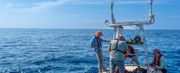
The workhorse of the research vessel is the Conductivity, Temperature, and Depth (CTD) sonde, or probe, attached to the rosette. The rosette is a frame that holds 12 Niskin bottles, which can be closed automatically to collect seawater at different depths. When full, the CTD and rosette assembly can weigh over 1000 lbs. A winch lowered the CTD into the water 75 times during the Hogarth’s seven days at sea. Each time it was brought back on deck, the scientists crowded around the rosette to collect the water samples. “Sometimes there are as many as five of us trying to get water all at once,” laughed Verrill.
In addition to the hundreds of samples taken by NOAA and FWC, the USF team created 270 samples from water collected at 62 stations during this particular research cruise. The number of stations visited and samples taken varies depending on the type of research and weather conditions. Samples were stored for HPLC analysis and other tests, including chlorophyll maximum, Colored Dissolved Organic Matter (CDOM), nutrient concentrations, dissolved oxygen, and trace metals. In addition, NOAA researchers operated the CPICS underwater microscope, which captures high-resolution images of organisms as small as 10 micrometers (10 µm)—a human hair is 50-100 µm.

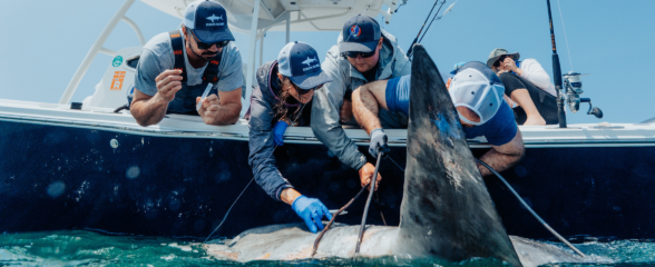
These HPLC pigment data and careful measurements of light reflected from the ocean’s uppermost few feet (collected with light probes from the ship) help NASA’s Ocean Biology Processing Group (OBPG) to calibrate and validate satellite imagery of phytoplankton concentrations across the oceans. Together with zooplankton tow net findings, environmental DNA (eDNA), temperature, salinity, and telemetry from tagged animals, including sharks and marine mammals, these “optical” measurements help the MBON teams interpret the color of the water and map the changing biogeography of marine life.
Although the technology has evolved—Humboldt used thermometers for water temperature, hydrometers for salinity, and calculated current speed from the ship’s drift—many of Humboldt’s measurements remain today’s Essential Ocean Variables (EOVs). These parameters include sea surface and subsurface temperatures, salinity, currents, and biological variables, which are measured with precision by the CTD. MBON has worked to identify and standardize EOVs, ensuring that marine protocols enable data sharing and reuse. Because these variables are relevant over time, the collected EOVs can always be used, even when technology and capability evolve. In the same way, MBON also works towards the adoption of Essential Biodiversity Variables (EBVs), which map changing genetic and community composition, species populations and traits, and ecosystem structure and function over time.
“We need to enhance ocean observation tools to really understand what’s going on,” says NOAA’s Ecosystem Assessment and Modeling scientist, Dr. Enrique Montes, “How corals and fishes and plankton and all the different components change with climate; what happens in an El Niño year versus La Niña year…”
“The only way of tackling those questions,” adds Montes, “is to be out in the ocean as frequently as possible, collecting data to refine our models.” Scientists are looking for minute changes that can be used to forecast trends in marine biodiversity, such as detecting seasonal movements of species.
A powerful addition to the scientists’ toolkit is eDNA sampling, which involves collecting genetic material—such as skin cells, tissues, and waste—shed by organisms into their surroundings.
This method enables researchers to identify diverse marine life, from microscopic plankton to large mammals, using water samples without capturing the organisms. The extraction and data analysis are handled by NOAA’s AOML lab.
“Since MBON’s inception in 2014, the sampling and the processing of the data have advanced,” observes Muller-Karger, “what hasn’t advanced at the same pace is the interpretation of that data.”
Because of sporadic funding, Dr. Montes and his team have only recently begun processing thousands of samples stored in a freezer, some for as long as 10 years. “There’s so much data out there,” Montes explains, “but it’s either inaccessible because it’s sitting in a fridge, on people’s computers, or it’s in the cloud in some obscure place.”
“Through MBON, we’ve been promoting the idea of publishing taxonomic data on the Ocean Biodiversity Information System (OBIS),” he adds. OBIS is an international, open database operated by the Intergovernmental Oceanographic Commission (IOC).
OBIS uses the Darwin Core (DwC) format as its primary data standard. DwC, a standardized set of terms that unifies fieldwork language, follows the logic of the museum specimen card, which, before the digital age, displayed a specimen’s description and geographic information. Similarly, DwC translates this “card logic” into a digital format, where What, Where, and When are recorded under specific English headers. For example, while a scientist in the Cariaco Basin files data might enter descriptive content in Spanish, the data itself is filed under universal terms like scientificName, decimalLatitude, and eventDate.
Once the data is “clean” (validated) and complies with Darwin Core standards, it can be uploaded to both OBIS and the Global Biodiversity Information Facility (GBIF), a global intergovernmental initiative with 69 country participants. This standardization effort simplifies the publication of biodiversity datasets and makes it easier for users to search and compare datasets globally.
Shareable, retrievable data is invaluable. “Scientists have an obligation to ensure that the data they collected for a particular study becomes of value for someone else, and that it can be found and reused,” affirms Montes, “because the studies are the interpretation of the data collected, but that interpretation may change over time.”
“The data they collect is the true value of their studies,” he adds.
Humboldt’s efforts to safeguard and share his data through his 30-volume work, Voyage aux régions équinoxiales du Nouveau Continent, highlight the importance of standardization.
Processing more than 7,000 pages of handwritten logs and narratives from his Americas expedition took him nearly 30 years.
Satellite Imaging

In February 2024, NASA launched its Earth-observing PACE (Plankton, Aerosol, Cloud, Ocean Ecosystem) satellite into orbit. PACE’s primary sensor, the Ocean Color Instrument (OCI), can detect over 200 wavelengths of light, compared to the 5-6 bands of the sensors on previous satellites. Scientists use PACE to measure the level of absorption of different colors by the water.
Based on decades of measurements worldwide, researchers can map the biomass of phytoplankton and other substances, such as dissolved organic matter (fulvic acid and tannins) and sediments, in the water. PACE can now distinguish between beneficial phytoplankton and algae that feed the food web and toxic “red tides” or cyanobacteria. Other satellites are used simultaneously to measure sea surface temperature, and the maps are used to track “heat waves” and cold currents that affect fish and whale migrations.
Scientist Maria Kavanaugh, at Oregon State University, leads the Northern California Current Marine Biodiversity Observation Network (NCC MBON). She has been working on satellite-derived biogeographic composites she calls “Seascapes”, an allusion to Humboldt’s “painting of nature”.
Professor Muller-Karger likens Seascapes to Humboldt’s infographic, but with movement and showing the passage of time. Each “dynamic seascape” leverages near-daily measurements from space: it superimposes images from different satellites that capture distinct properties, such as temperature, chlorophyll levels, wind, and sea level, to study plankton and ecosystem function at different times.
The data collected during research cruises, such as the Hogarth’s, are used to validate the Seascape images, to show that changes observed from a boat accurately reflect satellite data gathered from space.
“A Seascape is a biogeographic region that combines physical and biological categories, and allows us to compare them,” says Muller-Karger. “How do they relate to a particular marine life within the Seascape or moving from one Seascape to another?”
“There is a relation—we’ve seen that at certain temperatures and salinity, certain types of pigments represent certain phytoplankton, and that there is a seasonal change in the composition of the phytoplankton.” Muller-Karger acknowledges that changes are also occurring faster, not only seasonally: “Our goal is to explain what causes these changes in marine life.”
Those shifts in plankton and other community structures directly affect ecosystem resilience and the fishing and tourism industries. Being able to predict these changes is essential to food security, to predicting harmful algal blooms, and to developing options for industries such as fishing, mining, and coastal development.

Two centuries ago, a Renaissance man like Humboldt could do it all—explorer, naturalist, geographer, and philosopher. He recognized that understanding the natural world required integrating quantitative data and qualitative observation across diverse disciplines, as pieces to a grand puzzle.
As science grew increasingly specialized, his holistic approach was set aside: “For the longest time, ecologists, biologists, and geographers worked individually,” explains Professor Muller-Karger. “We learned to operate in networks that were discipline-specific.”
Today, MBON is reversing this trend by fostering collaboration and integration to deepen understanding of the critical relationships between marine life and their environment. By uniting experts across diverse fields, MBON is bridging the gap between long-term ecological research, eDNA analysis, remote sensing, and management strategies.
In an era of rapid changes to the nature of our world, Professor Muller-Karger reflects on the mission: “To forecast life, we need to be working together as one.”
USF’s Sebastian DiGeronimo wrote from the Hogarth overnight, as the vessel motored back to shore, skipping the last stations to beat the rough seas created by a strong front in the Atlantic beyond the Keys: “We saw a pod of 12 to 15 Atlantic spotted dolphins! How cool is that?”
How cool, indeed.
This work was supported by the U.S. Marine Biodiversity Observation Network (MBON) co-organized by NOAA, NASA, BOEM, and ONR through the National Oceanographic Partnership Program (NOPP).
Related news
Rebuilding the Future: USF’s College of Marine Science Recovers from Historic Blaze One Day at a Time
Following a devastating fire at USF’s Marine Science Lab, researchers rally to salvage decades of critical data and maintain vital ocean monitoring.

Reimagining the Deep: BioTrack and the Whitespotted Eagle Rays of Florida’s Indian River Lagoon
Join FAU researchers as they track endangered whitespotted eagle rays in Florida’s Indian River Lagoon using advanced BioTrack acoustic and video tags.
Reimagining the Deep: BioTrack’s Quest to Map Marine Biodiversity Hotspots
Discover how the BioTrack initiative uses advanced satellite and acoustic animal tracking to map marine biodiversity hotspots and protect endangered wildlife.